Difference between revisions of "2013-08-03 51 -0"
imported>PaintedJaguar (Add plans) |
imported>FippeBot m (Location) |
||
| (2 intermediate revisions by one other user not shown) | |||
| Line 7: | Line 7: | ||
__NOTOC__ | __NOTOC__ | ||
== Location == | == Location == | ||
| − | + | On Birchwood Way, near How Wood station just south of St. Albans | |
== Participants == | == Participants == | ||
| Line 20: | Line 20: | ||
== Expedition == | == Expedition == | ||
| − | + | This was a very easy expedition. The journey to How Wood was completed without a hitch, and from the station it was only a few minutes walk to the hashpoint. | |
| + | |||
| + | Google Maps satellite images had suggested the hashpoint was in somebody's front garden, whilst StreetView suggested it was on the grass verge outside their house. My GPS eventually showed it to be on the pavement between those two possible points, and although I did once manage to get it to say I was exactly at the hashpoint, it had drifted to 3 metres away by the time I'd got the camera out to take a photo, even though I wasn't actually moving! | ||
| + | |||
| + | I left a chalk marker on the pavement, and then returned to the station. I have to say possibly the nicest part of this expedition was the access road to the station, which was more of a narrow track than a road, and vehicles were in fact prohibited from using it. The tree branches alongside this lane had all joined together into a continuous canopy, giving a very nice "tunnel" to walk through. | ||
| + | |||
| + | I did manage to return to Cambridge in time to join Benjw on the later expeditions, making this: | ||
| + | * the first hash of two today, making a double hash with [[2013-08-03 52 0]] | ||
| + | * the first day of three days of consecutive geohashing, continuing with [[2013-08-04 52 0]] and [[2013-08-05 52 0]] | ||
== Tracklog == | == Tracklog == | ||
| − | + | http://www.wikiloc.com/wikiloc/view.do?id=4964354 shows the route from How Wood station to the hashpoint. | |
== Photos == | == Photos == | ||
| Line 30: | Line 38: | ||
--> | --> | ||
<gallery perrow="5"> | <gallery perrow="5"> | ||
| + | Image:2013-08-03_51_-0_how_wood_station.JPG | How Wood station access road. | ||
| + | Image:2013-08-03_51_-0_road_sign.JPG | Road sign for Birchwood Road. Fortunately I was on foot, so was allowed to enter. | ||
| + | Image:2013-08-03_51_-0_hashpoint.JPG | Approaching the hashpoint, which was outside the row of houses | ||
| + | Image:2013-08-03_51_-0_gps.JPG | At the hashpoint | ||
| + | Image:2013-08-03_51_-0_marker.JPG | Chalk marker left on pavement | ||
| + | Image:2013-08-03_51_-0_grin.JPG | Silly grin | ||
| + | Image:2013-08-03_51_-0_hashpoint_closeup.JPG | Closeup view of the hedge and house adjacent to the hashpoint | ||
| + | Image:2013-08-03_51_-0_view_from_hashpoint.JPG | View from the hashpoint | ||
| + | Image:2013-08-03_51_-0_train_tickets.JPG | Proof of public transport geohash. | ||
</gallery> | </gallery> | ||
== Achievements == | == Achievements == | ||
{{#vardefine:ribbonwidth|800px}} | {{#vardefine:ribbonwidth|800px}} | ||
| − | + | {{land geohash | |
| − | + | | latitude = 51 | |
| + | | longitude = -0 | ||
| + | | date = 2013-08-03 | ||
| + | | name = PaintedJaguar | ||
| + | }} | ||
| − | + | {{Public transport geohash | |
| − | + | | latitude = 51 | |
| − | + | | longitude = -0 | |
| + | | date = 2013-08-03 | ||
| + | | busline = the train | ||
| + | | name = PaintedJaguar | ||
| + | | image = 2013-08-03_51_-0_train_tickets.JPG | ||
| + | }} | ||
| − | |||
| − | |||
| − | |||
| − | |||
| − | |||
| − | |||
[[Category:Expeditions]] | [[Category:Expeditions]] | ||
| − | + | [[Category:Expeditions with photos]] | |
| − | [[Category:Expeditions with photos]] | ||
| − | |||
| − | |||
| − | |||
| − | |||
| − | |||
[[Category:Coordinates reached]] | [[Category:Coordinates reached]] | ||
| − | + | {{location|GB|ENG|HRT}} | |
| − | |||
| − | |||
| − | |||
| − | |||
| − | |||
| − | |||
| − | |||
| − | |||
| − | |||
| − | |||
| − | |||
| − | |||
| − | |||
| − | |||
| − | |||
| − | |||
| − | |||
Latest revision as of 03:27, 14 August 2019
| Sat 3 Aug 2013 in 51,-0: 51.7169253, -0.3540812 geohashing.info google osm bing/os kml crox |
Location
On Birchwood Way, near How Wood station just south of St. Albans
Participants
Plans
PaintedJaguar already has plans to travel from Cambridge to West London on Saturday, and leaving Cambridge a bit earlier than necessary will give him time to make a detour to this hashpoint.
He's aiming to head to Watford Junction, and then get the 11:14 train to How Wood, arriving at 11:24. This leaves him approximately 1 hour to get to the hashpoint and return to the train station for the 12:22 train back towards London.
If everything goes to plan in the afternoon, and he gets back to Cambridge in time, he may attempt to complete a double hash by joining Benjw for a midnight expedition to 2013-08-03 52 0 (and then also 2013-08-04 52 0).
Expedition
This was a very easy expedition. The journey to How Wood was completed without a hitch, and from the station it was only a few minutes walk to the hashpoint.
Google Maps satellite images had suggested the hashpoint was in somebody's front garden, whilst StreetView suggested it was on the grass verge outside their house. My GPS eventually showed it to be on the pavement between those two possible points, and although I did once manage to get it to say I was exactly at the hashpoint, it had drifted to 3 metres away by the time I'd got the camera out to take a photo, even though I wasn't actually moving!
I left a chalk marker on the pavement, and then returned to the station. I have to say possibly the nicest part of this expedition was the access road to the station, which was more of a narrow track than a road, and vehicles were in fact prohibited from using it. The tree branches alongside this lane had all joined together into a continuous canopy, giving a very nice "tunnel" to walk through.
I did manage to return to Cambridge in time to join Benjw on the later expeditions, making this:
- the first hash of two today, making a double hash with 2013-08-03 52 0
- the first day of three days of consecutive geohashing, continuing with 2013-08-04 52 0 and 2013-08-05 52 0
Tracklog
http://www.wikiloc.com/wikiloc/view.do?id=4964354 shows the route from How Wood station to the hashpoint.
Photos
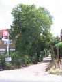
How Wood station access road.
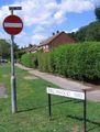
Road sign for Birchwood Road. Fortunately I was on foot, so was allowed to enter.
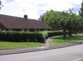
Approaching the hashpoint, which was outside the row of houses
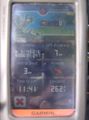
At the hashpoint
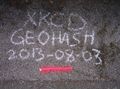
Chalk marker left on pavement

Silly grin
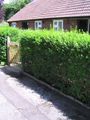
Closeup view of the hedge and house adjacent to the hashpoint
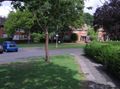
View from the hashpoint
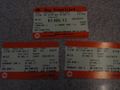
Proof of public transport geohash.


Achievements
PaintedJaguar earned the Land geohash achievement
|
PaintedJaguar earned the Public transport geohash achievement
|