Difference between revisions of "2013-08-05 45 -110"
imported>Michael5000 (→Participants) |
m (per Renaming Proposal) |
||
| (13 intermediate revisions by 3 users not shown) | |||
| Line 1: | Line 1: | ||
| − | |||
| − | |||
| − | |||
| − | |||
| − | |||
| − | |||
| − | |||
| − | |||
{{meetup graticule | {{meetup graticule | ||
| lat=45 | | lat=45 | ||
| Line 15: | Line 7: | ||
}} | }} | ||
| − | + | ||
__NOTOC__ | __NOTOC__ | ||
== Location == | == Location == | ||
| − | + | ||
| + | By Rocky Creek, in a field near the railroad a few miles east of Bozeman. | ||
== Participants == | == Participants == | ||
| Line 24: | Line 17: | ||
* [[User:Michael5000|Michael5000]] | * [[User:Michael5000|Michael5000]] | ||
| − | == | + | == Expedition == |
| − | |||
| − | + | I drove north from [[2013-08-05 44 -110]], and after getting some supplies in Bozeman found the general site area without any problem. My first walk in through the field got me confused -- the vegetation is over eye-high in places -- so I waded in along the creek (shown, apparently inaccurately, as the "East Gallatin River" on Google Maps) and got to the site without too much difficulty. | |
| − | + | ||
| + | Now here's the thing: I could have SWORN I was at least the second person at the hashpoint today. There was broken vegetation leading up to the hashpoint, and a little area right at the point that looked good and trampled. So, I was a little amazed to see that not only has nobody written up the expedition yet, but nobody has EVER written up an expedition in the Livingston graticule. I'm claiming the cherry for now, but if someone else claims they were at 2013-08-05 before me today, I'd believe 'em. Or, maybe a cow just happened to take a nap at the hashpoint a few days ago. | ||
| − | + | The day continued at [[2013-08-05 47 -111]]. | |
| − | |||
== Photos == | == Photos == | ||
| − | + | ||
| − | |||
| − | |||
<gallery perrow="5"> | <gallery perrow="5"> | ||
| + | File:2013-08-05 45 -110 sign.JPG|The hashpoint was in the brush just to the right of the sign. | ||
| + | File:2013-08-05 45 -110 view.JPG|View from the hashpoint. | ||
| + | File:2013-08-05 45 -110 me.JPG|Not an especially good hair day. | ||
</gallery> | </gallery> | ||
== Achievements == | == Achievements == | ||
{{#vardefine:ribbonwidth|800px}} | {{#vardefine:ribbonwidth|800px}} | ||
| − | |||
| + | *Michael5000's first Expedition to Montana. | ||
| − | + | {{Multihash2 | |
| − | + | | date = 2013-08-05 | |
| − | [[ | + | | count = 2 |
| + | | name = [[User:Michael5000|Michael5000]] | ||
| + | }} | ||
| − | + | {{consecutive geohash 2 | |
| − | |||
| − | |||
| − | |||
| − | + | | count = 3 | |
| − | + | | latitude = 45 | |
| − | + | | longitude = -121 | |
| − | + | | date = 2013-08-03 | |
| − | + | | name = [[User:Michael5000|Michael5000]] | |
| − | |||
| − | |||
| − | |||
| − | |||
| − | [[ | ||
| + | }} | ||
| − | + | {{Graticule unlocked | |
| − | |||
| − | |||
| − | |||
| − | |||
| − | |||
| − | |||
| − | |||
| − | + | | latitude = 45 | |
| − | + | | longitude = -110 | |
| − | + | | date = 2013-08-05 | |
| − | + | | name = [[User:Michael5000|Michael5000]] | |
| − | [[ | + | }} |
| − | + | [[Category:Expeditions]] | |
| + | [[Category:Expeditions with photos]] | ||
| + | [[Category:Coordinates reached]] | ||
| + | {{location|US|MT|GL}} | ||
Latest revision as of 05:22, 20 March 2024
| Mon 5 Aug 2013 in 45,-110: 45.6693250, -110.9701443 geohashing.info google osm bing/os kml crox |
Location
By Rocky Creek, in a field near the railroad a few miles east of Bozeman.
Participants
Expedition
I drove north from 2013-08-05 44 -110, and after getting some supplies in Bozeman found the general site area without any problem. My first walk in through the field got me confused -- the vegetation is over eye-high in places -- so I waded in along the creek (shown, apparently inaccurately, as the "East Gallatin River" on Google Maps) and got to the site without too much difficulty.
Now here's the thing: I could have SWORN I was at least the second person at the hashpoint today. There was broken vegetation leading up to the hashpoint, and a little area right at the point that looked good and trampled. So, I was a little amazed to see that not only has nobody written up the expedition yet, but nobody has EVER written up an expedition in the Livingston graticule. I'm claiming the cherry for now, but if someone else claims they were at 2013-08-05 before me today, I'd believe 'em. Or, maybe a cow just happened to take a nap at the hashpoint a few days ago.
The day continued at 2013-08-05 47 -111.
Photos
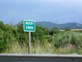
The hashpoint was in the brush just to the right of the sign.
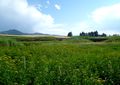
View from the hashpoint.

Not an especially good hair day.


Achievements
- Michael5000's first Expedition to Montana.
Michael5000 earned the Multihash Achievement
|
Michael5000 earned the Consecutive geohash achievement
|
Michael5000 earned the Graticule Unlocked Achievement
|