Difference between revisions of "2013-09-02 51 9"
imported>GeorgDerReisende (new expedition to Asche) |
imported>FippeBot m (Location) |
||
| (3 intermediate revisions by 2 users not shown) | |||
| Line 1: | Line 1: | ||
| − | |||
| − | |||
| − | |||
| − | |||
| − | |||
| − | |||
| − | |||
| − | |||
| − | |||
| − | |||
{{meetup graticule | {{meetup graticule | ||
| lat=51 | | lat=51 | ||
| Line 15: | Line 5: | ||
}} | }} | ||
| − | + | ||
__NOTOC__ | __NOTOC__ | ||
== Location == | == Location == | ||
| − | + | ||
| + | The hash lies in the fields between Asche and Erbsen. | ||
== Participants == | == Participants == | ||
| − | + | ||
| − | + | * [[User:GeorgDerReisende|GeorgDerReisende]] | |
== Plans == | == Plans == | ||
| − | + | ||
| + | To hitchhike to the place, to walk through the fields, to hitchhike home. | ||
== Expedition == | == Expedition == | ||
| − | |||
| − | + | First remark: I didn't realize that the sundown is so early these days. | |
| − | + | ||
| + | I hitchhiked from Kassel via Göttingen to Hardegsen, from there I walked to Ellierode, then I walked onto the road to Fehrlingsen. | ||
| + | After one kilometer I got a lift into my direction and I waited for a village with the name ''Fehrlingsen'' to drop off. But after passing the village ''Asche'' no other village ''Fehrlingsen'' appeared. | ||
| + | |||
| + | So I stayed off and walked back. Then I walked along the street and through the fields. Then I have found the place of the hash and have had the usual fun. | ||
| + | |||
| + | Then I walked to Erbsen. From there I tried to hitchhike to Göttingen, but it was now dark. Nobody stopped. Then I walked to Emmenhausen, where I have waited another long time for a car, but none of the cars stopped. So I took the bus. | ||
| + | |||
| + | I arrived at the junction Göttingen of the A7 at 23:50. After 15 minutes I got a lift to the petrol station at Heiligenrode, from there I walked home, where I arrived at 2 o'clock in the morning. | ||
== Photos == | == Photos == | ||
| − | + | ||
| − | |||
| − | |||
<gallery perrow="5"> | <gallery perrow="5"> | ||
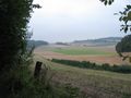
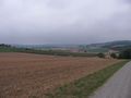
| + | Image:2013-09-02 51 9 GeorgDerReisende 9307.jpg | the view to the hash area | ||
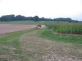
| + | Image:2013-09-02 51 9 GeorgDerReisende 9331.jpg | nearer to the hash | ||
| + | Image:2013-09-02 51 9 GeorgDerReisende 9337.jpg | proof1 | ||
| + | Image:2013-09-02 51 9 GeorgDerReisende 9334.jpg | proof2 | ||
| + | Image:2013-09-02 51 9 GeorgDerReisende 9338.jpg | view to the northeast | ||
| + | Image:2013-09-02 51 9 GeorgDerReisende 9339.jpg | view to the north | ||
| + | Image:2013-09-02 51 9 GeorgDerReisende 9340.jpg | view to the northwest | ||
| + | Image:2013-09-02 51 9 GeorgDerReisende 9341.jpg | view to the southwest | ||
| + | Image:2013-09-02 51 9 GeorgDerReisende 9342.jpg | view to the south | ||
| + | Image:2013-09-02 51 9 GeorgDerReisende 9343.jpg | view to the southeast | ||
| + | Image:2013-09-02 51 9 GeorgDerReisende 9348.jpg | grin | ||
| + | Image:2013-09-02 51 9 GeorgDerReisende 9349.jpg | the internet was here! | ||
| + | Image:2013-09-02 51 9 GeorgDerReisende 9351.jpg | view to the hash from above, in the background the village ''Asche'' | ||
| + | Image:2013-09-02 51 9 GeorgDerReisende 9355.jpg | the way to Erbsen | ||
</gallery> | </gallery> | ||
== Achievements == | == Achievements == | ||
{{#vardefine:ribbonwidth|800px}} | {{#vardefine:ribbonwidth|800px}} | ||
| − | |||
| − | + | {{Thumbs Up | latitude = 51 | longitude = 9 | date = 2013-09-02 | name = GeorgDerReisende }} | |
| − | + | ||
| − | + | {{Regional geohashing | name = GeorgDerReisende | region = Landkreis Northeim | count = 2 }} | |
| + | |||
| − | |||
| − | |||
| − | |||
| − | |||
| − | |||
[[Category:Expeditions]] | [[Category:Expeditions]] | ||
| − | |||
[[Category:Expeditions with photos]] | [[Category:Expeditions with photos]] | ||
| − | |||
| − | |||
| − | |||
| − | |||
| − | |||
[[Category:Coordinates reached]] | [[Category:Coordinates reached]] | ||
| − | + | {{location|DE|NI|NOM}} | |
| − | |||
| − | |||
| − | |||
| − | |||
| − | |||
| − | |||
| − | |||
| − | |||
| − | |||
| − | |||
| − | |||
| − | |||
| − | |||
| − | |||
| − | |||
| − | |||
| − | |||
Latest revision as of 03:50, 14 August 2019
| Mon 2 Sep 2013 in 51,9: 51.6028551, 9.8134778 geohashing.info google osm bing/os kml crox |
Location
The hash lies in the fields between Asche and Erbsen.
Participants
Plans
To hitchhike to the place, to walk through the fields, to hitchhike home.
Expedition
First remark: I didn't realize that the sundown is so early these days.
I hitchhiked from Kassel via Göttingen to Hardegsen, from there I walked to Ellierode, then I walked onto the road to Fehrlingsen. After one kilometer I got a lift into my direction and I waited for a village with the name Fehrlingsen to drop off. But after passing the village Asche no other village Fehrlingsen appeared.
So I stayed off and walked back. Then I walked along the street and through the fields. Then I have found the place of the hash and have had the usual fun.
Then I walked to Erbsen. From there I tried to hitchhike to Göttingen, but it was now dark. Nobody stopped. Then I walked to Emmenhausen, where I have waited another long time for a car, but none of the cars stopped. So I took the bus.
I arrived at the junction Göttingen of the A7 at 23:50. After 15 minutes I got a lift to the petrol station at Heiligenrode, from there I walked home, where I arrived at 2 o'clock in the morning.
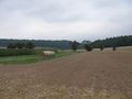
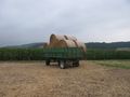
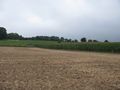
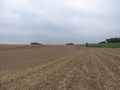
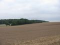
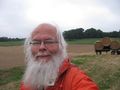
Photos
the view to the hash area
nearer to the hash
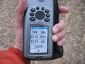
proof1
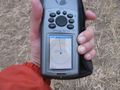
proof2
view to the northeast
view to the north
view to the northwest
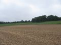
view to the southwest
view to the south
view to the southeast
grin
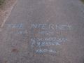
the internet was here!
view to the hash from above, in the background the village Asche
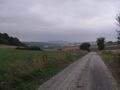
the way to Erbsen


Achievements
GeorgDerReisende earned the Thumbs Up Geohash Achievement
|
GeorgDerReisende earned the Regional geohashing achievement
|