Difference between revisions of "2013-09-13 45 -122"
imported>Frogman (→Participants) |
imported>FippeBot m (Location) |
||
| (7 intermediate revisions by 2 users not shown) | |||
| Line 15: | Line 15: | ||
}} | }} | ||
| − | + | ||
__NOTOC__ | __NOTOC__ | ||
== Location == | == Location == | ||
| − | + | ||
Hazeldale Park in Aloha, OR. | Hazeldale Park in Aloha, OR. | ||
== Participants == | == Participants == | ||
| − | + | ||
| − | + | * [[User:Frogman|Frogman]] and | |
| − | [[User:Frogman|Frogman]] | + | * Alison |
| + | |||
| + | * [[User:Jiml|Jim]] | ||
== Plans == | == Plans == | ||
| − | + | ||
| + | === Expedition One === | ||
| + | |||
| + | Excited from getting his driver's license, my friend Dmitriy asked me if I wanted to go geohashing after I got off of work. Unfortunately, he had to cancel our plans, but that didn't stop Alison and I from going. | ||
| + | |||
| + | === Expedition Two === | ||
| + | |||
| + | In the morning on the way off to work, Jim noticed that the hashpoint was very accessible, and figured he'd go by after work. | ||
== Expedition == | == Expedition == | ||
| − | |||
| − | == | + | === Expedition One === |
| − | + | ||
| + | The hashpoint was in a very nice park west of Beaverton, near some athletic fields. After reaching the hashpoint, we decided to use the playground equipment! Slides are not as fun as I had remembered, but Alison enjoyed herself. | ||
| + | |||
| + | The hardest part of the trip was rush-hour traffic on a Friday on our way back. Even at 3 the traffic on state highway 8 was horribly congested. After we got onto I-405 it was fun because I enjoy looking at interchanges. | ||
| + | |||
| + | |||
| + | === Expedition Two === | ||
| + | |||
| + | Well, Jim drove by the hashpoint on his way to meet the train to work, and then drove by on his way back in the evening, but | ||
| + | was in a rush to an appointment, and so didn't get a chance to go by then. | ||
| + | |||
| + | Finally, around 8ish, I managed to swing by the park. It was pretty easy to find my way there, though a flashlight was | ||
| + | needed to avoid toppling over into the nearby stream on the way into the park in the pitch black. | ||
| + | |||
| + | The hashpoint appeared to be right in the middle of the walkway near the (only?) baseball diamond, but I didn't see any | ||
| + | markings. I also couldn't take any photos since the camera ended up doing an unplanned stay at home today. | ||
== Photos == | == Photos == | ||
| − | + | ||
| − | |||
| − | |||
<gallery perrow="5"> | <gallery perrow="5"> | ||
| + | Image:2013-09-13 45 -122 proof.png | Proof! | ||
| + | Image:2013-09-13 45 -122 thehashpoint.jpg | A bit to the left of the drinking fountain and right off the path. | ||
| + | Image:2013-09-13 45 -122 goofygrins.jpg | Us at the hashpoint | ||
| + | Image:2013-09-13 45 -122 sliding.jpg | Us having fun near the hashpoint | ||
</gallery> | </gallery> | ||
== Achievements == | == Achievements == | ||
{{#vardefine:ribbonwidth|800px}} | {{#vardefine:ribbonwidth|800px}} | ||
| − | |||
| − | |||
| − | + | * Land Geohash | |
| − | |||
| − | |||
| − | |||
| − | |||
| − | |||
| − | |||
| − | |||
[[Category:Expeditions]] | [[Category:Expeditions]] | ||
| − | |||
[[Category:Expeditions with photos]] | [[Category:Expeditions with photos]] | ||
| − | + | ||
| − | |||
| − | |||
| − | |||
| − | |||
[[Category:Coordinates reached]] | [[Category:Coordinates reached]] | ||
| − | + | {{location|US|OR|WI}} | |
| − | |||
| − | |||
| − | |||
| − | |||
| − | |||
| − | |||
| − | |||
| − | |||
| − | |||
| − | |||
| − | |||
| − | |||
| − | |||
| − | |||
| − | |||
| − | |||
| − | |||
Latest revision as of 03:58, 14 August 2019
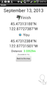
| Fri 13 Sep 2013 in 45,-122: 45.4731319, -122.8772739 geohashing.info google osm bing/os kml crox |
Location
Hazeldale Park in Aloha, OR.
Participants
- Frogman and
- Alison
Plans
Expedition One
Excited from getting his driver's license, my friend Dmitriy asked me if I wanted to go geohashing after I got off of work. Unfortunately, he had to cancel our plans, but that didn't stop Alison and I from going.
Expedition Two
In the morning on the way off to work, Jim noticed that the hashpoint was very accessible, and figured he'd go by after work.
Expedition
Expedition One
The hashpoint was in a very nice park west of Beaverton, near some athletic fields. After reaching the hashpoint, we decided to use the playground equipment! Slides are not as fun as I had remembered, but Alison enjoyed herself.
The hardest part of the trip was rush-hour traffic on a Friday on our way back. Even at 3 the traffic on state highway 8 was horribly congested. After we got onto I-405 it was fun because I enjoy looking at interchanges.
Expedition Two
Well, Jim drove by the hashpoint on his way to meet the train to work, and then drove by on his way back in the evening, but was in a rush to an appointment, and so didn't get a chance to go by then.
Finally, around 8ish, I managed to swing by the park. It was pretty easy to find my way there, though a flashlight was needed to avoid toppling over into the nearby stream on the way into the park in the pitch black.
The hashpoint appeared to be right in the middle of the walkway near the (only?) baseball diamond, but I didn't see any markings. I also couldn't take any photos since the camera ended up doing an unplanned stay at home today.
Photos
Proof!
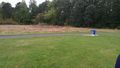
A bit to the left of the drinking fountain and right off the path.

Us at the hashpoint
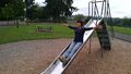
Us having fun near the hashpoint


Achievements
- Land Geohash