Difference between revisions of "2013-09-14 47 11"
imported>LeslieHapablap (→Plans) |
imported>FippeBot m (Location) |
||
| (13 intermediate revisions by one other user not shown) | |||
| Line 8: | Line 8: | ||
And DON'T FORGET to add your expedition and the best photo you took to the gallery on the Main Page! We'd love to read your report, but that means we first have to discover it! :) | And DON'T FORGET to add your expedition and the best photo you took to the gallery on the Main Page! We'd love to read your report, but that means we first have to discover it! :) | ||
--> | --> | ||
| − | [[Image:20130914 panorama.jpg|900px]] | + | [[Image:20130914 panorama.jpg|left|900px]] |
{{meetup graticule | {{meetup graticule | ||
| lat=47 | | lat=47 | ||
| Line 14: | Line 14: | ||
| date=2013-09-14 | | date=2013-09-14 | ||
}} | }} | ||
| − | + | {{ClearLeft}} | |
<!-- edit as necessary --> | <!-- edit as necessary --> | ||
__NOTOC__ | __NOTOC__ | ||
| Line 25: | Line 25: | ||
--> | --> | ||
* [[User:EleanorAbernathy|EleanorAbernathy]] | * [[User:EleanorAbernathy|EleanorAbernathy]] | ||
| − | * [[User:LeslieHapablap|LeslieHapablap]], ([[2013-09-10 48 11|previous]]) | + | * [[User:LeslieHapablap|LeslieHapablap]], ([[2013-09-10 48 11|previous]]|[[2013-09-23 47 7|next]]) |
| − | * Waltraud the hashkiwi | + | * [[User:LeslieHapablap/Waltraud|Waltraud]] the hashkiwi |
== Plans == | == Plans == | ||
| Line 34: | Line 34: | ||
== Expedition == | == Expedition == | ||
<!-- how it all turned out. your narrative goes here. --> | <!-- how it all turned out. your narrative goes here. --> | ||
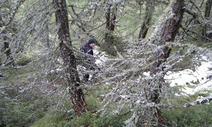
| + | [[File:2013-09-14 47 11 14-29-32-984.jpg|300px|thumb|left|Scenic vew.]] | ||
After a beautiful summer it seems like autumn has hit Innsbruck with chilly temperatures and rain on the last couple of days. This turns into snow above 1500 m altitude and the mountaintops are white again. When the weather forecast predicted relatively friendly weather on Saturday we really wanted to go geohashing again as there are probably not so many chances anymore to go on an expedition in the mountains before winter arrives. Luckily the Dow Jones approved of our plan and sent us to the Navis valley not too far from Innsbruck. | After a beautiful summer it seems like autumn has hit Innsbruck with chilly temperatures and rain on the last couple of days. This turns into snow above 1500 m altitude and the mountaintops are white again. When the weather forecast predicted relatively friendly weather on Saturday we really wanted to go geohashing again as there are probably not so many chances anymore to go on an expedition in the mountains before winter arrives. Luckily the Dow Jones approved of our plan and sent us to the Navis valley not too far from Innsbruck. | ||
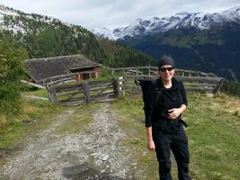
| + | [[File:2013-09-14 47 11 14-12-43-629.jpg|300px|thumb|right|[[User:EleanorAbernathy|EleanorAbernathy]].]] | ||
Even though the distance was similar to our expedition in the [[2013-08-24 47 11|Stubai valley]], this one was not as exhausting with a walking time of only about 4.5 hours in total and only 500 m altitude to climb. After driving by car for about 45 minutes we started to walk at 10.15am on relatively broad forest roads which allowed us to advance quickly. On our way we saw a cute cat and stopped to pet it (yay for the hashcat achievement). Later we left the forest road and walked on a trail which took us to the Miesl-Alm, an alpine cabin. The cabin was located at 2000 a.s.l. and closed at this time of the year. Here we rested and had our lunch which we packed. It really payed out now that we were considerate enough to bring along warm clothing. | Even though the distance was similar to our expedition in the [[2013-08-24 47 11|Stubai valley]], this one was not as exhausting with a walking time of only about 4.5 hours in total and only 500 m altitude to climb. After driving by car for about 45 minutes we started to walk at 10.15am on relatively broad forest roads which allowed us to advance quickly. On our way we saw a cute cat and stopped to pet it (yay for the hashcat achievement). Later we left the forest road and walked on a trail which took us to the Miesl-Alm, an alpine cabin. The cabin was located at 2000 a.s.l. and closed at this time of the year. Here we rested and had our lunch which we packed. It really payed out now that we were considerate enough to bring along warm clothing. | ||
| Line 44: | Line 46: | ||
== Tracklog == | == Tracklog == | ||
<!-- if your GPS device keeps a log, you may post a link here --> | <!-- if your GPS device keeps a log, you may post a link here --> | ||
| + | Our [http://goo.gl/maps/dZG0b tracklog]. | ||
== Photos == | == Photos == | ||
| Line 87: | Line 90: | ||
Image:2013-09-14_47_11_14-07-30-270.jpg | Blueberries! | Image:2013-09-14_47_11_14-07-30-270.jpg | Blueberries! | ||
| − | Image:2013-09-14_47_11_14-31-38-662.jpg | LeslieHapablap performing the usual GPS dance to get the best reading. | + | Image:2013-09-14_47_11_14-31-38-662.jpg | [[User:LeslieHapablap|LeslieHapablap]] performing the usual GPS dance to get the best reading. |
Image:20130914 panorama.jpg | Panorama view of the hashpoint. | Image:20130914 panorama.jpg | Panorama view of the hashpoint. | ||
| − | Image:2013-09-14_47_11_14-08-49-695.jpg | Obligatory silly grin, with Waltraud the | + | Image:2013-09-14_47_11_14-08-49-695.jpg | Obligatory silly grin, with [[User:LeslieHapablap/Waltraud|Waltraud]] the hashkiwi. |
Image:2013-09-14_47_11_14-16-17-896.jpg | Obligatory proof. | Image:2013-09-14_47_11_14-16-17-896.jpg | Obligatory proof. | ||
| Line 109: | Line 112: | ||
<!-- Add any achievement ribbons you earned below, or remove this section --> | <!-- Add any achievement ribbons you earned below, or remove this section --> | ||
| + | {{land geohash | ||
| + | |||
| + | | latitude = 47 | ||
| + | | longitude = 11 | ||
| + | | date = 2013-09-14 | ||
| + | | name = [[User:EleanorAbernathy|EleanorAbernathy]] and [[User:LeslieHapablap|LeslieHapablap]] | ||
| + | |||
| + | }} | ||
| + | {{Hashcat | ||
| + | | latitude = 47 | ||
| + | | longitude = 11 | ||
| + | | date = 2013-09-14 | ||
| + | | name = [[User:EleanorAbernathy|EleanorAbernathy]] and [[User:LeslieHapablap|LeslieHapablap]] | ||
| + | |||
| + | }} | ||
<!-- =============== USEFUL CATEGORIES FOLLOW ================ | <!-- =============== USEFUL CATEGORIES FOLLOW ================ | ||
Delete the next line ONLY if you have chosen the appropriate categories below. If you are unsure, don't worry. People will read your report and help you with the classification. --> | Delete the next line ONLY if you have chosen the appropriate categories below. If you are unsure, don't worry. People will read your report and help you with the classification. --> | ||
| Line 124: | Line 142: | ||
[[Category:Expedition without GPS]] | [[Category:Expedition without GPS]] | ||
--> | --> | ||
| + | [[Category:Expeditions]] | ||
[[Category:Coordinates reached]] | [[Category:Coordinates reached]] | ||
| + | [[Category:Expeditions with photos]] | ||
<!-- if you reached your coords: | <!-- if you reached your coords: | ||
[[Category:Coordinates reached]] | [[Category:Coordinates reached]] | ||
| Line 145: | Line 165: | ||
(Don't forget to delete this final close comment marker) --> | (Don't forget to delete this final close comment marker) --> | ||
| + | {{location|AT|T|IL}} | ||
Latest revision as of 03:59, 14 August 2019

| Sat 14 Sep 2013 in 47,11: 47.1454788, 11.5319066 geohashing.info google osm bing/os kml crox |
Location
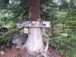
Navis valley, near Mislalm.
Participants
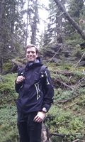
- EleanorAbernathy
- LeslieHapablap, (previous|next)
- Waltraud the hashkiwi
Plans
We plan to walk up from Kerschbaumsiedlung, Oberweg, and hope to arrive at the hashpoint at 1pm. This time it is not quite clear if the coordinates are accessible. It has snowed at that altitude the last few days and satellite images show some rocks which could indicate a cliff. On the other hand the weather forecast is quite pleasant tomorrow and it might be one of the last chances to geohash in the mountains before winter arrives. We will see how it turns out.
Expedition

After a beautiful summer it seems like autumn has hit Innsbruck with chilly temperatures and rain on the last couple of days. This turns into snow above 1500 m altitude and the mountaintops are white again. When the weather forecast predicted relatively friendly weather on Saturday we really wanted to go geohashing again as there are probably not so many chances anymore to go on an expedition in the mountains before winter arrives. Luckily the Dow Jones approved of our plan and sent us to the Navis valley not too far from Innsbruck.

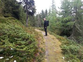
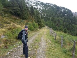
Even though the distance was similar to our expedition in the Stubai valley, this one was not as exhausting with a walking time of only about 4.5 hours in total and only 500 m altitude to climb. After driving by car for about 45 minutes we started to walk at 10.15am on relatively broad forest roads which allowed us to advance quickly. On our way we saw a cute cat and stopped to pet it (yay for the hashcat achievement). Later we left the forest road and walked on a trail which took us to the Miesl-Alm, an alpine cabin. The cabin was located at 2000 a.s.l. and closed at this time of the year. Here we rested and had our lunch which we packed. It really payed out now that we were considerate enough to bring along warm clothing.
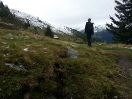
With renewed strength we set off for the last few kilometers to the hashpoint. Soon the trail was only hardly recognizable, and the last few hundred meters were completely cross-country. Even though the terrain was quite steep and wet we didn't have too much trouble reaching the coordinates. We were right on time for the Saturday meetup at 1pm and took the usual pictures. We even left a marker made of sticks and snow at the hashpoint this time.
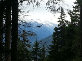
The way back to our car was quite uneventful. We found back to our trail without problems and descended to the valley even accompanied by the sun at some moments. Altogether it was a nice walk for a Saturday morning, with beautiful scenic views as always in the alps.
Tracklog
Our tracklog.
Photos

We have new neighbors at home these days!
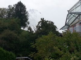
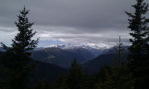
The misty mountain.
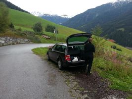
Our parking spot at Kerschbaumsiedlung.
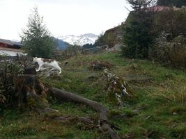
A hashcat!
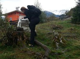
Purrrrrrrrrrrrrrrr.
Miesl-Alm was along our route.
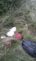
A fly agaric along our way.
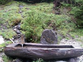
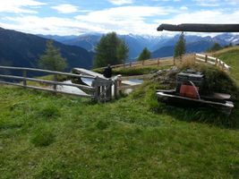
Miesl-Alm.
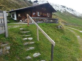
Miesl-Alm.

A water wheel at the Alm.
Not so far from the coordinates.
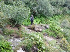
Cross-country again.
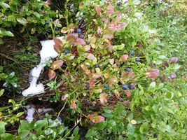
Blueberries!
LeslieHapablap performing the usual GPS dance to get the best reading.

Panorama view of the hashpoint.
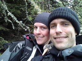
Obligatory silly grin, with Waltraud the hashkiwi.
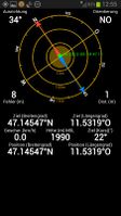
Obligatory proof.
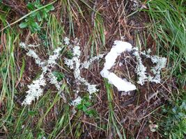
We left a marker made of sticks and snow.
Even the sun came out for a while.
Sheep at the horizon.


Achievements
EleanorAbernathy and LeslieHapablap earned the Land geohash achievement
|
EleanorAbernathy and LeslieHapablap earned the Hashcat achievement
|