Difference between revisions of "2013-09-17 -43 171"
imported>Quaternary (→Plans) |
m (per Renaming Proposal) |
||
| (5 intermediate revisions by 2 users not shown) | |||
| Line 1: | Line 1: | ||
| − | |||
| − | |||
| − | + | [[Image:{{{image|2013_09_17_-43_171_Onsite.jpg}}}|thumb|left]] | |
| − | |||
| + | <!-- If you did not specify these parameters in the template, please substitute appropriate values for IMAGE, LAT, LON, and DATE (YYYY-MM-DD format) | ||
And DON'T FORGET to add your expedition and the best photo you took to the gallery on the Main Page! We'd love to read your report, but that means we first have to discover it! :) | And DON'T FORGET to add your expedition and the best photo you took to the gallery on the Main Page! We'd love to read your report, but that means we first have to discover it! :) | ||
--> | --> | ||
| Line 34: | Line 32: | ||
== Photos == | == Photos == | ||
| − | < | + | |
| − | Image: | + | <gallery perrow="4"> |
| − | - | + | Image:2013_09_17_-43_171_Onsite.jpg | Onsite - holding the marker |
| − | + | Image:2013_09_17_-43_171_The Marker.jpg | The marker | |
| + | Image:2013_09_17_-43_171_Arrived.jpg | Arrived! | ||
| + | Image:2013_09_17_-43_171_Date and Time.png | Screenshot of GPS device! | ||
</gallery> | </gallery> | ||
| Line 43: | Line 43: | ||
{{#vardefine:ribbonwidth|800px}} | {{#vardefine:ribbonwidth|800px}} | ||
<!-- Add any achievement ribbons you earned below, or remove this section --> | <!-- Add any achievement ribbons you earned below, or remove this section --> | ||
| + | |||
| + | {{Graticule unlocked | ||
| + | |||
| + | | latitude = -43 | ||
| + | | longitude = 171 | ||
| + | | date = 2013-09-17 | ||
| + | | name = Quaternary | ||
| + | |||
| + | }} | ||
| Line 54: | Line 63: | ||
[[Category:Coordinates reached]] | [[Category:Coordinates reached]] | ||
<!-- YIPPEE --> | <!-- YIPPEE --> | ||
| + | {{location|NZ|CAN}} | ||
Latest revision as of 05:20, 20 March 2024

| Tue 17 Sep 2013 in -43,171: -43.7514902, 171.9974819 geohashing.info google osm bing/os kml crox |
Location
Rakaia, New Zealand
Participants
Plans
A happy convergence of fate! Looking at the Geohashing Coordinate Calculator it was apparent that in the neighbouring graticule to where I live, there was a publically accessible geohash location PLUS we had to go and pick up a Trademe (online auction) purchase about one kilometre away from it. This calls for some geohashing! (Son, you'd better take the day off school - otherwise there would be no-one to be in the photo).
Expedition
With the Trademe item successfully picked up (a beehive) it was off to find the geohash. It was found without too much of a problem. One of the neighbours came out and shared a yarn with us - he thought it was pretty cool concept and was a little sad that it wasn't on his property :)
Tracklog
Photos
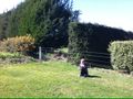
Onsite - holding the marker
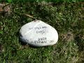
The marker
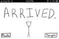
Arrived!
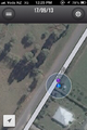
Screenshot of GPS device!


Achievements
Quaternary earned the Graticule Unlocked Achievement
|