Difference between revisions of "2013-09-19 66 25"
From Geohashing
imported>Isopekka |
imported>FippeBot m (Location) |
||
| (One intermediate revision by one other user not shown) | |||
| Line 42: | Line 42: | ||
Image: Gh19092013.jpg| The Proof. | Image: Gh19092013.jpg| The Proof. | ||
Image: 2013-09-19 16.49.36 (1024x768).jpg| The Hash. | Image: 2013-09-19 16.49.36 (1024x768).jpg| The Hash. | ||
| − | Image: 2013-09-19 16.49.59 (1024x768).jpg | View from the hash. | + | Image: 2013-09-19 16.49.59 (1024x768).jpg | View to the North from the hash. |
| − | Image: 2013-09-19 16.52.29 (1024x768).jpg | View from the hash. | + | Image: 2013-09-19 16.52.29 (1024x768).jpg | View to the South from the hash. |
| Line 56: | Line 56: | ||
| latitude = 66 | | latitude = 66 | ||
| longitude = 25 | | longitude = 25 | ||
| − | |date = 2013- | + | |date = 2013-09-19 |
| name = isopekka | | name = isopekka | ||
| Line 73: | Line 73: | ||
[[Category:Expeditions with photos]] | [[Category:Expeditions with photos]] | ||
[[Category:Coordinates reached]] | [[Category:Coordinates reached]] | ||
| + | {{location|FI|10}} | ||
Latest revision as of 04:03, 14 August 2019
.jpg)
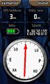
| Thu 19 Sep 2013 in 66,25: 66.5359765, 25.8002534 geohashing.info google osm bing/os kml crox |
Contents
Location
In Syväsenvaara, in forest.
Participants
Expedition
- Driving total 16 km
- Walking total 0.4 km
- Expedition took 0.5 h
- Physical effort (1-5): 1
Expedition started about at 4:30 p.m. The Hashpoint situated in the forest.
Photos
The Proof.
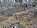
The Hash.
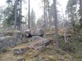
View to the North from the hash.
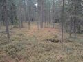
View to the South from the hash.

.jpg)
.jpg)
Achievements
isopekka earned the Land geohash achievement
|
Geohashing Expeditions and Plans on This Day
Expeditions and Plans
| 2013-09-19 | ||
|---|---|---|
| Beersheba, Israel | LinaK | In a field at the Lachish region, close to Highway 6 and The Israel Trail, ... |
| Hannover, Germany | GeorgDerReisende | The hash lies in a small forest south of the interchange between the motorw... |
| Rovaniemi, Finland | isopekka | In Syväsenvaara, in forest. |