Difference between revisions of "2013-10-03 49 8"
imported>RecentlyChanged (Created page with "{{subst:Expedition |lat = 49 | lon = 8 | date = 2013-10-03}}") |
m |
||
| (13 intermediate revisions by 3 users not shown) | |||
| Line 1: | Line 1: | ||
| − | |||
| − | |||
| − | |||
| − | |||
| − | |||
| − | |||
| − | |||
| − | |||
| − | |||
| − | |||
{{meetup graticule | {{meetup graticule | ||
| lat=49 | | lat=49 | ||
| Line 17: | Line 7: | ||
<!-- edit as necessary --> | <!-- edit as necessary --> | ||
__NOTOC__ | __NOTOC__ | ||
| − | |||
| − | |||
| − | |||
== Participants == | == Participants == | ||
| − | + | Svenja, teamtec and [[User:RecentlyChanged|RecentlyChanged]] | |
| − | |||
| − | |||
| − | |||
| − | |||
== Expedition == | == Expedition == | ||
| − | + | We took the tram from the University to the station next to the Hash. We had to walk one station back just once because we were in the wrong tram but that's ok, that's less bad than usual. | |
| + | It was about twenty minutes to walk from the station and not even very deep in the forest, so it was a pretty easy hash. It was great for introducing [[User:Svenja|Svenja]] into hashing. I don't know until now whether she liked it or not. | ||
| + | But it was a great idea to go hashing because the weather was fine and we were learning for two weeks at that point because the next day we had a test, we had even to write it a second time because we did not pass in the first try. While Geohashing we were relaxing a little bit, it was great. | ||
== Tracklog == | == Tracklog == | ||
| − | + | http://www.everytrail.com/view_trip.php?trip_id=2358159 | |
== Photos == | == Photos == | ||
| − | |||
| − | |||
| − | |||
<gallery perrow="5"> | <gallery perrow="5"> | ||
| + | Image:IMG_20131003_180118_888.geaendert.jpg| RecentlyChanged and teamtec | ||
| + | Image:2013-10-03 49 8 Svenja.jpg|Svenja | ||
</gallery> | </gallery> | ||
== Achievements == | == Achievements == | ||
{{#vardefine:ribbonwidth|800px}} | {{#vardefine:ribbonwidth|800px}} | ||
| − | + | {{land geohash | latitude = 49 | longitude = 8 | date = 2013-10-03 | name = Svenja, teamtec and RecentlyChanged}} | |
| + | {{Public transport geohash | latitude = 49 | longitude = 8 | date = 2013-10-03 | busline = KVV | name = Svenja, teamtec and RecentlyChanged }} | ||
| + | {{drag-along | latitude = 49 | longitude = 8 | date = 2013-10-03 | name = teamtec and [[User:RecentlyChanged|RecentlyChanged]] | partner = Svenja}} | ||
| + | {{Minesweeper geohash | ||
| + | | graticule = Pforzheim, Germany | ||
| + | | ranknumber = 1 | ||
| + | | n = true | ||
| + | | name = teamtec | ||
| + | }} | ||
| + | {{Two to the N achievement | ||
| + | | count = 0 | ||
| + | | date = 2013-10-03 | ||
| + | | latitude = 49 | ||
| + | | longitude = 8 | ||
| + | | name = Svenja | ||
| + | | reached = true | ||
| + | }} | ||
| − | |||
| − | |||
| − | |||
| − | |||
| − | |||
| − | |||
| − | |||
| − | |||
| − | |||
| − | |||
| − | |||
[[Category:Expeditions]] | [[Category:Expeditions]] | ||
| − | + | [[Category:Expeditions with photos]] | |
| − | [[Category:Expeditions with photos]] | ||
| − | |||
| − | |||
| − | |||
| − | |||
| − | |||
[[Category:Coordinates reached]] | [[Category:Coordinates reached]] | ||
| − | + | {{location|DE|BW|KA|city=true}} | |
| − | |||
| − | |||
| − | |||
| − | |||
| − | |||
| − | |||
| − | |||
| − | |||
| − | |||
| − | |||
| − | |||
| − | |||
| − | |||
| − | |||
| − | |||
| − | |||
| − | |||
Latest revision as of 16:44, 26 March 2020
| Thu 3 Oct 2013 in 49,8: 49.0328436, 8.4761851 geohashing.info google osm bing/os kml crox |
Participants
Svenja, teamtec and RecentlyChanged
Expedition
We took the tram from the University to the station next to the Hash. We had to walk one station back just once because we were in the wrong tram but that's ok, that's less bad than usual. It was about twenty minutes to walk from the station and not even very deep in the forest, so it was a pretty easy hash. It was great for introducing Svenja into hashing. I don't know until now whether she liked it or not. But it was a great idea to go hashing because the weather was fine and we were learning for two weeks at that point because the next day we had a test, we had even to write it a second time because we did not pass in the first try. While Geohashing we were relaxing a little bit, it was great.
Tracklog
http://www.everytrail.com/view_trip.php?trip_id=2358159
Photos
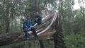
RecentlyChanged and teamtec
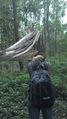
Svenja


Achievements
Svenja, teamtec and RecentlyChanged earned the Land geohash achievement
|
Svenja, teamtec and RecentlyChanged earned the Public transport geohash achievement
|
teamtec and RecentlyChanged earned the Drag-along achievement
|
teamtec achieved level 1 of the Minesweeper Geohash achievement
|
