Difference between revisions of "2013-10-06 44 -123"
imported>Frogman (→Participants) |
imported>FippeBot m (Location) |
||
| (8 intermediate revisions by 2 users not shown) | |||
| Line 24: | Line 24: | ||
== Plans == | == Plans == | ||
| − | + | Perhaps a bit geohash-starved in this rather difficult graticule, I was pleasantly surprised to find a hashpoint not in the middle of a field, but instead rather close to the edge of a field! I asked my friends to drive me, but they thought it would be pretty silly to drive over half an hour to take a picture of a field and turn around again. | |
== Expedition == | == Expedition == | ||
| − | + | I can geohash if I want to; I can leave my friends behind. I decided to take my bike! It was only a 44-mile round-trip from Corvallis. | |
| + | |||
| + | The Willamette Valley in early fall is absolutely gorgeous. I headed down US Numbered Highway 99W and was greeted with a pretty strong headwind, which made the southbound journey difficult and my return journey a ''breeze''. The sun was still high in the sky and the farmland was framed by mountains was very picturesque. I took a picture! | ||
| + | |||
| + | After 11 miles on 99W I turned onto Old River Road. There weren't many cars around, which was amazing. I saw pumpkins! | ||
| + | |||
| + | The hashpoint itself was just off of a road on the alluvial Ingram Island in a corn field. As luck would have it, right as I arrived a man was just beginning to harvest the field. He probably has a pretty weird story to tell his coworkers: "I saw this kid ride up on a bike, take a picture of me, and leave." I watched the corn fly through the air and into his trailer for a few minutes and rode home. | ||
| + | |||
| + | At home Alison was waiting for me with a chai latte! It was decaf, because it was around 7 at night when I got back, sore and feeling accomplished at visiting yet another arbitrary location. | ||
== Tracklog == | == Tracklog == | ||
| Line 37: | Line 45: | ||
--> | --> | ||
<gallery perrow="5"> | <gallery perrow="5"> | ||
| + | Image:2013-10-06 44 -123 nice view.jpg | It was a very nice day out. | ||
| + | Image:2013-10-06 44 -123 nice view2.jpg | Very very nice. | ||
| + | Image:2013-10-06 44 -123 sign.jpg | The road to turn off of from 99W! | ||
| + | Image:2013-10-06 44 -123 old river road.jpg | This is the road. | ||
| + | Image:2013-10-06 44 -123 sign post.jpg | The sign posts out here have lots of signs on them. This is actually one of the less-populated ones. | ||
| + | Image:2013-10-06_44_-123_pumpkins.jpg | Look! Pumpkin is sleeping. | ||
| + | Image:2013-10-06 44 -123 y.jpg | What I was thinking about then. Biking is tiring. | ||
| + | Image:2013-10-06 44 -123 llama.jpg | My new best friend. It is either a llama or an alpaca; I am not very well-versed in these things. | ||
| + | Image:2013-10-06 44 -123 combine.jpg | What people do at hashpoints: harvest corn. | ||
| + | Image:2013-10-06_44_-123_ingram_slough.jpg | The Ingram Slough! This is what makes Ingram Island an island. | ||
| + | Image:2013-10-06_44_-123_sunset.jpg | The sun was setting as I rode back on 99W. | ||
| + | Image:2013-10-06 44 -123 bike mirror.jpg | My goofy non-grin, through a bike mirror. | ||
</gallery> | </gallery> | ||
| Line 42: | Line 62: | ||
{{#vardefine:ribbonwidth|800px}} | {{#vardefine:ribbonwidth|800px}} | ||
<!-- Add any achievement ribbons you earned below, or remove this section --> | <!-- Add any achievement ribbons you earned below, or remove this section --> | ||
| + | {{bicycle geohash | ||
| + | | latitude = 44 | ||
| + | | longitude = -123 | ||
| + | | date = 2013-10-06 | ||
| + | | name = [[User:Frogman|Frogman]] ([[User talk:Frogman|talk]]) | ||
| + | | distance = 44.0 miles | ||
| + | | bothways = true | ||
| + | | image = 2013-10-06_44_-123_bike_mirror.jpg | ||
| + | }} | ||
| + | {{Regional geohashing | ||
| + | | name = [[User:Frogman|Frogman]] ([[User talk:Frogman|talk]]) | ||
| + | | region = Benton County, Oregon | ||
| + | | count = 1 | ||
| + | }} | ||
| − | |||
| − | |||
| − | |||
| − | + | [[Category:Expeditions]] | |
| − | |||
| − | [[Category: | ||
| − | |||
| − | |||
| − | |||
| − | |||
[[Category:Expeditions with photos]] | [[Category:Expeditions with photos]] | ||
| − | + | ||
| − | |||
| − | |||
| − | |||
| − | |||
[[Category:Coordinates reached]] | [[Category:Coordinates reached]] | ||
| − | + | {{location|US|OR|BE}} | |
| − | |||
| − | |||
| − | |||
| − | |||
| − | |||
| − | |||
| − | |||
| − | |||
| − | |||
| − | |||
| − | |||
| − | |||
| − | |||
| − | |||
| − | |||
| − | |||
| − | |||
Latest revision as of 04:14, 14 August 2019
| Sun 6 Oct 2013 in 44,-123: 44.3090708, -123.2243903 geohashing.info google osm bing/os kml crox |
Location
A corn farm in rural Benton County, Oregon.
Participants
Plans
Perhaps a bit geohash-starved in this rather difficult graticule, I was pleasantly surprised to find a hashpoint not in the middle of a field, but instead rather close to the edge of a field! I asked my friends to drive me, but they thought it would be pretty silly to drive over half an hour to take a picture of a field and turn around again.
Expedition
I can geohash if I want to; I can leave my friends behind. I decided to take my bike! It was only a 44-mile round-trip from Corvallis.
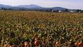
The Willamette Valley in early fall is absolutely gorgeous. I headed down US Numbered Highway 99W and was greeted with a pretty strong headwind, which made the southbound journey difficult and my return journey a breeze. The sun was still high in the sky and the farmland was framed by mountains was very picturesque. I took a picture!
After 11 miles on 99W I turned onto Old River Road. There weren't many cars around, which was amazing. I saw pumpkins!
The hashpoint itself was just off of a road on the alluvial Ingram Island in a corn field. As luck would have it, right as I arrived a man was just beginning to harvest the field. He probably has a pretty weird story to tell his coworkers: "I saw this kid ride up on a bike, take a picture of me, and leave." I watched the corn fly through the air and into his trailer for a few minutes and rode home.
At home Alison was waiting for me with a chai latte! It was decaf, because it was around 7 at night when I got back, sore and feeling accomplished at visiting yet another arbitrary location.
Tracklog
Photos
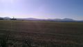
It was a very nice day out.
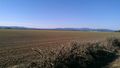
Very very nice.
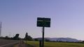
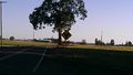
The road to turn off of from 99W!
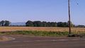
This is the road.
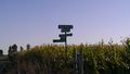
The sign posts out here have lots of signs on them. This is actually one of the less-populated ones.
Look! Pumpkin is sleeping.
What I was thinking about then. Biking is tiring.
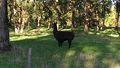
My new best friend. It is either a llama or an alpaca; I am not very well-versed in these things.
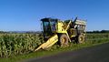
What people do at hashpoints: harvest corn.
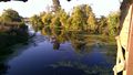
The Ingram Slough! This is what makes Ingram Island an island.
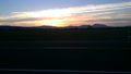
The sun was setting as I rode back on 99W.
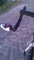
My goofy non-grin, through a bike mirror.


Achievements
Frogman (talk) earned the Bicycle geohash achievement
|
Frogman (talk) earned the Regional geohashing achievement
|