Difference between revisions of "2013-10-12 46 7"
imported>TheOneRing (Created page with "{{meetup graticule | lat=46 | lon=7 | date=2013-10-12 }} == Location == The geohash is on field or meadow near Mühlenthurnen. == Who Went == *TheOneRing...") |
m (per Renaming Proposal) |
||
| (6 intermediate revisions by 2 users not shown) | |||
| Line 6: | Line 6: | ||
== Location == | == Location == | ||
| − | The geohash is on | + | The geohash is on a meadow near Mühlenthurnen. |
== Who Went == | == Who Went == | ||
*[[User:TheOneRing|TheOneRing]] - by public transport. | *[[User:TheOneRing|TheOneRing]] - by public transport. | ||
| − | == The | + | == The Expedition == |
| − | I | + | === TheOneRing === |
| + | I decided quite late to go and took that train which brought me to the geohash right in time. From the train station, it was a walk of approx. 1km parallel to the rivulet Gürbe. | ||
| + | |||
| + | As I had to practice Alphorn anyway today, I had it with me. I found the geohash on a meadow and though it rained the last couple of days, the ground was good and not very muddy. | ||
| + | |||
| + | As a special photograph I took a 360° panoramic view around the geohash. Remarkably, the Alps are already covered with snow down to an altitude of about 1200m. I took the regular photos, too. | ||
| + | |||
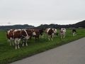
| + | Thereafter: practising time. I started, and beside normal people a herd of cows came to me. They were interested, though not very enthusiastic. | ||
| + | |||
| + | I waited until 4pm but when nobody else came I walked back to the train station. | ||
| + | |||
| + | == Photos == | ||
| + | <gallery perrow="5"> | ||
| + | Image:20131012_46_7GPS.jpg|Coordinates reached | ||
| + | Image:20131012_46_7Me.jpg|The happy hasher | ||
| + | Image:20131012_46_7Panorama.jpg|A 360° panoramic view | ||
| + | Image:20131012_46_7Alphorn.jpg|Me and my alphorn | ||
| + | Image:20131012_46_7Publikum.jpg|The stunned audience | ||
| + | </gallery> | ||
| + | |||
| + | == Achievements == | ||
| + | {{land geohash | latitude = 46 | longitude = 7 | date = 2013-10-12 | name = TheOneRing}} | ||
| + | {{Public transport geohash | latitude = 46 | longitude = 7 | date = 2013-10-12 | name = TheOneRing}} | ||
| + | {{gratuitous ribbon | color = lightsteelblue | latitude = 46 | longitude = 7 | date = 2013-10-12 | achievement = Heimatfilm Hero Achievement | description = playing his alphorn on a Switzerland meadow: the | name = TheOneRing | icon = OWN Ribbon.jpg }} | ||
| + | {{xkcd centurion | count = 7 | name = TheOneRing}} | ||
| + | |||
| + | [[Category:Expeditions]] | ||
| + | [[Category:Expeditions with photos]] | ||
| + | [[Category:Coordinates reached]] | ||
| + | {{location|CH|BE}} | ||
Latest revision as of 13:49, 2 April 2024
| Sat 12 Oct 2013 in 46,7: 46.8059799, 7.5191998 geohashing.info google osm bing/os kml crox |
Location
The geohash is on a meadow near Mühlenthurnen.
Who Went
- TheOneRing - by public transport.
The Expedition
TheOneRing
I decided quite late to go and took that train which brought me to the geohash right in time. From the train station, it was a walk of approx. 1km parallel to the rivulet Gürbe.
As I had to practice Alphorn anyway today, I had it with me. I found the geohash on a meadow and though it rained the last couple of days, the ground was good and not very muddy.
As a special photograph I took a 360° panoramic view around the geohash. Remarkably, the Alps are already covered with snow down to an altitude of about 1200m. I took the regular photos, too.
Thereafter: practising time. I started, and beside normal people a herd of cows came to me. They were interested, though not very enthusiastic.
I waited until 4pm but when nobody else came I walked back to the train station.
Photos
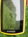
Coordinates reached
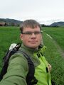
The happy hasher
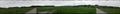
A 360° panoramic view
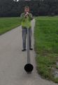
Me and my alphorn
The stunned audience


Achievements
TheOneRing earned the Land geohash achievement
|
TheOneRing earned the Public transport geohash achievement
|
TheOneRing earned the Heimatfilm Hero Achievement
|
TheOneRing earned the xkcd Nullaturion achievement
|