Difference between revisions of "2013-10-25 42 -90"
imported>Michael5000 (→Photos) |
Michael5000 (talk | contribs) (→Tracklog) |
||
| (3 intermediate revisions by 2 users not shown) | |||
| Line 23: | Line 23: | ||
== Participants == | == Participants == | ||
| − | [[User:Michael5000|Michael5000]] | + | [[User:Michael5000|Michael5000]] -- Expedition #148 |
== Plans == | == Plans == | ||
| Line 32: | Line 32: | ||
The hashpoint was on a gravel road in rolling hills a mile or two from the little village of St. Donatus. If you were at liberty to drive a hundred miles to get to it, it presented no other particular challenges on site. The area where Illinois, Iowa, and Wisconsin meet is hilly and charming, and Dubuque looked pretty quaint on a bright fall day. It was a nice little drive. | The hashpoint was on a gravel road in rolling hills a mile or two from the little village of St. Donatus. If you were at liberty to drive a hundred miles to get to it, it presented no other particular challenges on site. The area where Illinois, Iowa, and Wisconsin meet is hilly and charming, and Dubuque looked pretty quaint on a bright fall day. It was a nice little drive. | ||
| − | |||
| − | |||
| − | |||
== Photos == | == Photos == | ||
| Line 50: | Line 47: | ||
<!-- Add any achievement ribbons you earned below, or remove this section --> | <!-- Add any achievement ribbons you earned below, or remove this section --> | ||
| + | *Michael5000's 7th state attempted and 6th state with a successful expedition. | ||
| − | |||
| − | |||
| − | |||
| − | |||
| − | |||
| − | |||
| − | |||
| − | |||
| − | |||
| − | |||
[[Category:Expeditions]] | [[Category:Expeditions]] | ||
| − | |||
[[Category:Expeditions with photos]] | [[Category:Expeditions with photos]] | ||
| − | |||
| − | |||
| − | |||
| − | |||
| − | |||
[[Category:Coordinates reached]] | [[Category:Coordinates reached]] | ||
| − | + | {{location|US|IA|JC}} | |
| − | |||
| − | |||
| − | |||
| − | |||
| − | |||
| − | |||
| − | |||
| − | |||
| − | |||
| − | |||
| − | |||
| − | |||
| − | |||
| − | |||
| − | |||
| − | |||
| − | |||
Latest revision as of 20:11, 16 April 2022
| Fri 25 Oct 2013 in 42,-90: 42.3768374, -90.5588657 geohashing.info google osm bing/os kml crox |
Location
Off of Highway 52, southeast of Dubuque, Iowa.
Participants
Michael5000 -- Expedition #148
Plans
I flew into Chicago at 5 a.m. Friday, and don't need to be anywhere until Sunday afternoon. I got my rental car and headed west; once the hashpoints were out I stopped at a coffeeshop in Winnebago and looked for a likely expedition.
Expedition
The hashpoint was on a gravel road in rolling hills a mile or two from the little village of St. Donatus. If you were at liberty to drive a hundred miles to get to it, it presented no other particular challenges on site. The area where Illinois, Iowa, and Wisconsin meet is hilly and charming, and Dubuque looked pretty quaint on a bright fall day. It was a nice little drive.
Photos
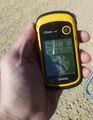
Was I really there? Yes, I was really there.

Goofy grin; rental Expedition Vehicle in background.
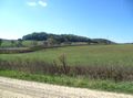
"You were wandering out on the hills of Iowa and you were not thinking of me."
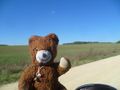
Greetings from Iowa!
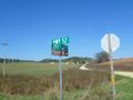
This way to the hashpoint.
.JPG)
.JPG)
.JPG)
.JPG)
.JPG)
Achievements
- Michael5000's 7th state attempted and 6th state with a successful expedition.