Difference between revisions of "2013-10-27 47 12"
imported>B2c (→Expedition) |
imported>B2c |
||
| Line 1: | Line 1: | ||
| − | |||
| − | |||
| − | |||
| − | |||
| − | |||
| − | |||
| − | |||
| − | |||
| − | |||
| − | |||
{{meetup graticule | {{meetup graticule | ||
| lat=47 | | lat=47 | ||
| Line 15: | Line 5: | ||
}} | }} | ||
| − | + | == Expedition Report: DST Timetravel Pt.2 == | |
| − | + | This is part two of a two part series describing an attempt to perform the DST Timetravel multihash achievement. For part one please [[2013-10-27 47 13| take a look over here]]. | |
| + | |||
| + | |||
== Location == | == Location == | ||
| − | + | [[Image:GeohashTimetravellerAttempt 33.jpg| thumb | left | The Rosenheim hashpoint: Behind the fence in the middle of the two white buildings.]]The hashpoint was located in in the suburb Raubling some clicks outside of Rosenheim. While the area isn't densely populated the hashpoint of course had to fall into someone's garden. Oh my. | |
| + | <br><br><br><br><br><br><br><br> | ||
| + | |||
== Participants == | == Participants == | ||
| − | * [[User:Patrizius|Patrizius]] | + | * [[User:Patrizius|Patrizius]] && C. |
* [[User:B2c|B2c]] | * [[User:B2c|B2c]] | ||
| − | + | ||
| − | |||
== Plans == | == Plans == | ||
| − | + | Well, the plan was to ''get there as fast as possible'', as they only had one hour to make it from the outskirts of Salzburg to this hashpoint. (For extensive planning details please check part one of the expedition report.) | |
| + | |||
== Expedition == | == Expedition == | ||
| − | + | [[Image:GeohashTimetravellerAttempt 11.jpg| thumb| left | | On the fast lane.]](continued from [[2013-10-27 47 13]] - remember, our merry buch of geohashers is still in Salzburg at this time!) They drove down the hill as fast as the poor road condition and all the wet foliage would allow, slowly working their way through the Salzburg suburbs towards the A1 motorway, which would eventually merge into the A8 at the german border. As the minutes were ticking away and everbody was clenching their teeth, the Salzburg suburbs slowly crawled by in front of their windshield. When they finally passed the Salzburg city limits and hit the motorway they held their breath: the stopwatch showed that they were about a minute faster than while doing the dry-run a couple hours ago. Now the fat BMW could finally be at its best: going fast on a straight line. Even though the night was clear and the good weather held up, one could go only so fast on the A1, as the speed limit in Austria was lower and there were some construction sites which could only be passd slowly. That said the ride went pretty smooth for them at that point. | |
| + | |||
| + | As they finally crossed the german border at [http://goo.gl/Y2sRrR Walserberg] and entered the A8 the stopwatch still was below 20mins. Their hopes were slowly growing - they might really make it at this point! After that moment everything seemed like a blur for them, minutes and waypoint flying by as they raced through the pitch black night towards an imaginary goal that some algorithm had spat out a couple of days ago. But the time for such considerations had long gone by. Now they were determined to reach Rosenheim and get to the hashpoint in time. C. was double-checking their timing all the way and Patrizius was recalculating the remaining distance to get an estimates on their ETA while B2c tried to stop blinking. At this point they had already travelled over 600km in 7 hours and although they were hyped at this point it had been a long and straining night... | ||
| + | |||
| + | As they took the motorway exit and finally approached the Rosenheim outskirts, the clock turned over. 10minutes to go. Frantically checking the stopwatch and trying not to miss any turns they drove through the Raubling suburbs. 6 minutes to the deadline they came to a halt at the back of the buildings they had scouted out some hours before, jumped out of the car and made their way through an old, overgrown access road towards the hashpoint. | ||
| + | Here is Patrizius' original post from the Geohash Droid app, '''originally creating this page as he was lying in wait with B2c in an overgrown access road just behind the garden shed. The geohash was only a couple of meters away!''' | ||
*Gg -- [[User:Patrizius|Patrizius]] ([[User talk:Patrizius|talk]]) [http://www.openstreetmap.org/?lat=47.78832614&lon=12.09788415&zoom=16&layers=B000FTF @47.7883,12.0979] 21:06, 26 October 2013 (EDT) | *Gg -- [[User:Patrizius|Patrizius]] ([[User talk:Patrizius|talk]]) [http://www.openstreetmap.org/?lat=47.78832614&lon=12.09788415&zoom=16&layers=B000FTF @47.7883,12.0979] 21:06, 26 October 2013 (EDT) | ||
| + | |||
| + | At that point they were truly relieved for the first time - they had made it! Now they only had to wait two more minutes, jump the fence, run over to the hashpoint, take some pics and get the h*** out of dodge. At that point Patrizius noticed that the GPS didn't show the correct time - for some reason | ||
| + | it had ignored DST and showed them being one hour late! (Of course the damned thing would show the correct time exactly one hour later. WTF, Garmin?) Well at that point there wasn't much they could do about that. The clock hit 2:09h. They jumped the fence. The motion sensors turned on the exterior lighting. No turning back now. | ||
| + | |||
| + | |||
| + | == Aftermath == | ||
| + | After having taken some pictures they quickly made their way back to the car and then, out of town. They still couldn't believe that they had pulled it off as they drove all the way back to Vienna. It had been a log day. An even longer night. After over 11 hours and more than 1100km of driving, waiting, running around in woods and on other people's property, they arrived in Vienna. Tired but happy the saw each other off and went for a good day's sleep. | ||
| + | |||
== Tracklog == | == Tracklog == | ||
| − | < | + | [[Image:Tracklog gpsvisualizer dst tt.png|1024px| thumb| left |Tracklog of the operation. The wiki doesn't allow upload of .kml files so i tried to visualize it as good as it gets with gpsvisualizer. File is available on request.]] |
| + | <br><br><<br><br><br><br><br><br><br><br><br><br><br><br><br><br><br><br><br><br><br><br><br><br><br><br><br><br><br><br> | ||
| + | |||
| + | |||
| + | |||
| + | == Thx go out to... == | ||
| + | * Big shoutout to Patrizius and C. for their support and willingness to join in on this thing. Without them this wouldn't have been possible. I mean, who in his right mind wants to be locked up for 10 hours strait in a car with some crazy guy racing from point A to B? | ||
| + | * Whoever is in charge of the german autobahn: thanks for lifting that speed limit. | ||
| + | * All those fellow techies out there who keep those servers running, satellites flying and phones working. Without you this probably would have been a pretty boring, forgotten 2 page memo that got shelfed in a filing cabinet a long time ago. | ||
| + | * ...and Randall Munroe / xkcd of course ;) | ||
| − | |||
| − | |||
| − | |||
| − | |||
| − | |||
| − | |||
== Achievements == | == Achievements == | ||
| − | {{ | + | * Combined achievements for both of the [[2013-10-27 47 13]] and [[2013-10-27 47 12]] hashes: |
| − | + | {{land geohash | |
| + | | latitude = 47 | ||
| + | | longitude = 12 | ||
| + | | date = 2013-10-27 | ||
| + | }} | ||
| + | {{Multihash2 | ||
| + | | count = 2 | ||
| + | | date = 2013-10-27 | ||
| + | }} | ||
| + | {{Border geohash achievement | ||
| + | | latitude = 47 | ||
| + | | longitude = 12 | ||
| + | | date = 2013-10-27 | ||
| + | | country1 = Austria | ||
| + | | country2 = Germany | ||
| + | | name = B2c | ||
| + | }} | ||
| + | {{drag-along | ||
| + | | latitude = 47 | ||
| + | | longitude = 12 | ||
| + | | date = 2013-10-27 | ||
| + | | partner = C. | ||
| + | | name = B2c | ||
| + | | image = GeohashTimetravellerAttempt 2.jpg | ||
| + | }} | ||
| + | {{Earliest geohasher | ||
| + | | latitude = 47 | ||
| + | | longitude = 12 | ||
| + | | date = 2013-10-27 | ||
| + | | name = B2c | ||
| + | }} | ||
| + | {{Ribbon | ||
| + | | color = silver | ||
| + | | icon = TimeTravel.PNG | ||
| + | | user = {{{name| B2c}}} | ||
| + | | achievement = [[Time-Traveller Geohash]] Achievement | ||
| + | | action = reaching both the [http://irc.peeron.com/xkcd/map/map.html?lat=47&long=13&date=2013-10-27 (47, 13)] and [http://irc.peeron.com/xkcd/map/map.html?lat=47&long=12&date=2013-10-27 (47, 12) geohashes] exactly on 2013-10-27, at 02:09 AM | ||
| + | | category = Time-traveller achievement | ||
| + | }} | ||
| + | == Photos == | ||
| + | <gallery caption="Photo Gallery" widths="320px" heights="213px" perrow="3"> | ||
| + | Image:GeohashTimetravellerAttempt 13.jpg | Going probably way too fast on the autobahn. | ||
| + | Image:GeohashTimetravellerAttempt 31.jpg | Closing in on Rosenheim. Only 19mins to go... | ||
| + | Image:Google maps rosenheim2.png | A zoomed in satellite view of the hash spot. | ||
| + | Image:GeohashTimetravellerAttempt 33.jpg | The hashpoint in real life(tm): in the middle of the two buildings on the patio. | ||
| + | Image:GeohashTimetravellerAttempt 32.jpg | Our hiding place in the shrubbery behind the shed. | ||
| + | Image:Min-IMG 20131027 020522 1.jpg | Woot! We made it in time! (Disregard the misbehaving GPS clock display, plz.) | ||
| + | Image:Min-IMG 20131027 020941.jpg | Mission accomplished! | ||
| + | Image:Min-IMG 20131027 021104.jpg | GPS fix on the position. | ||
| + | Image:Min-IMG 20131027 021108.jpg | 02:11h - time to go before we wake the neighborhood. | ||
| + | Image:GeohashTimetravellerAttempt 34.jpg | Another view on the hashpoint. | ||
| + | Image:GeohashTimetravellerAttempt 5.jpg | One happy geohasher. | ||
| + | Image:Min-IMG 20131027 055544.jpg | Arriving in Vienna at 05:54h (for the record). | ||
| + | </gallery> | ||
| − | |||
| − | |||
[[Category:New report]] | [[Category:New report]] | ||
| − | |||
| − | |||
| − | |||
[[Category:Expedition planning]] | [[Category:Expedition planning]] | ||
| − | |||
| − | |||
| − | |||
[[Category:Expeditions]] | [[Category:Expeditions]] | ||
| − | |||
[[Category:Expeditions with photos]] | [[Category:Expeditions with photos]] | ||
| − | |||
| − | |||
| − | |||
| − | |||
| − | |||
[[Category:Coordinates reached]] | [[Category:Coordinates reached]] | ||
| − | + | [[Category: Meetup on 2013-10-27]] | |
| − | + | [[Category: Meetup in 47 12]] | |
| − | |||
| − | |||
| − | |||
| − | |||
| − | |||
| − | |||
| − | |||
| − | [[Category: | ||
| − | |||
| − | |||
| − | |||
| − | |||
| − | |||
| − | [[Category: | ||
| − | |||
| − | |||
Revision as of 13:43, 1 November 2013
| Sun 27 Oct 2013 in 47,12: 47.7883884, 12.0978016 geohashing.info google osm bing/os kml crox |
Contents
Expedition Report: DST Timetravel Pt.2
This is part two of a two part series describing an attempt to perform the DST Timetravel multihash achievement. For part one please take a look over here.
Location

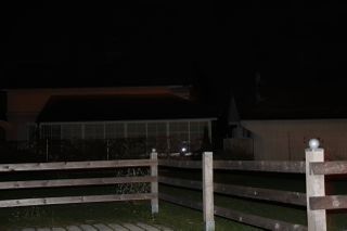
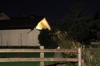
The hashpoint was located in in the suburb Raubling some clicks outside of Rosenheim. While the area isn't densely populated the hashpoint of course had to fall into someone's garden. Oh my.
Participants
Plans
Well, the plan was to get there as fast as possible, as they only had one hour to make it from the outskirts of Salzburg to this hashpoint. (For extensive planning details please check part one of the expedition report.)
Expedition

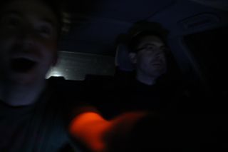
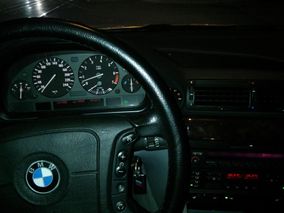
(continued from 2013-10-27 47 13 - remember, our merry buch of geohashers is still in Salzburg at this time!) They drove down the hill as fast as the poor road condition and all the wet foliage would allow, slowly working their way through the Salzburg suburbs towards the A1 motorway, which would eventually merge into the A8 at the german border. As the minutes were ticking away and everbody was clenching their teeth, the Salzburg suburbs slowly crawled by in front of their windshield. When they finally passed the Salzburg city limits and hit the motorway they held their breath: the stopwatch showed that they were about a minute faster than while doing the dry-run a couple hours ago. Now the fat BMW could finally be at its best: going fast on a straight line. Even though the night was clear and the good weather held up, one could go only so fast on the A1, as the speed limit in Austria was lower and there were some construction sites which could only be passd slowly. That said the ride went pretty smooth for them at that point.
As they finally crossed the german border at Walserberg and entered the A8 the stopwatch still was below 20mins. Their hopes were slowly growing - they might really make it at this point! After that moment everything seemed like a blur for them, minutes and waypoint flying by as they raced through the pitch black night towards an imaginary goal that some algorithm had spat out a couple of days ago. But the time for such considerations had long gone by. Now they were determined to reach Rosenheim and get to the hashpoint in time. C. was double-checking their timing all the way and Patrizius was recalculating the remaining distance to get an estimates on their ETA while B2c tried to stop blinking. At this point they had already travelled over 600km in 7 hours and although they were hyped at this point it had been a long and straining night...
As they took the motorway exit and finally approached the Rosenheim outskirts, the clock turned over. 10minutes to go. Frantically checking the stopwatch and trying not to miss any turns they drove through the Raubling suburbs. 6 minutes to the deadline they came to a halt at the back of the buildings they had scouted out some hours before, jumped out of the car and made their way through an old, overgrown access road towards the hashpoint.
Here is Patrizius' original post from the Geohash Droid app, originally creating this page as he was lying in wait with B2c in an overgrown access road just behind the garden shed. The geohash was only a couple of meters away!
- Gg -- Patrizius (talk) @47.7883,12.0979 21:06, 26 October 2013 (EDT)
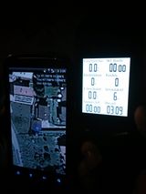
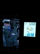
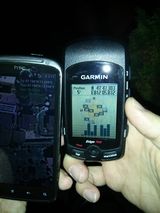
At that point they were truly relieved for the first time - they had made it! Now they only had to wait two more minutes, jump the fence, run over to the hashpoint, take some pics and get the h*** out of dodge. At that point Patrizius noticed that the GPS didn't show the correct time - for some reason it had ignored DST and showed them being one hour late! (Of course the damned thing would show the correct time exactly one hour later. WTF, Garmin?) Well at that point there wasn't much they could do about that. The clock hit 2:09h. They jumped the fence. The motion sensors turned on the exterior lighting. No turning back now.
Aftermath
After having taken some pictures they quickly made their way back to the car and then, out of town. They still couldn't believe that they had pulled it off as they drove all the way back to Vienna. It had been a log day. An even longer night. After over 11 hours and more than 1100km of driving, waiting, running around in woods and on other people's property, they arrived in Vienna. Tired but happy the saw each other off and went for a good day's sleep.
Tracklog

<
Thx go out to...
- Big shoutout to Patrizius and C. for their support and willingness to join in on this thing. Without them this wouldn't have been possible. I mean, who in his right mind wants to be locked up for 10 hours strait in a car with some crazy guy racing from point A to B?
- Whoever is in charge of the german autobahn: thanks for lifting that speed limit.
- All those fellow techies out there who keep those servers running, satellites flying and phones working. Without you this probably would have been a pretty boring, forgotten 2 page memo that got shelfed in a filing cabinet a long time ago.
- ...and Randall Munroe / xkcd of course ;)
Achievements
- Combined achievements for both of the 2013-10-27 47 13 and 2013-10-27 47 12 hashes:
This user earned the Land geohash achievement
|
This user earned the Multihash Achievement
|
B2c earned the Border geohash achievement
|
B2c earned the Drag-along achievement
|
B2c earned the Earliest geohasher achievement
|
B2c earned the Time-Traveller Geohash Achievement
|
Photos
- Photo Gallery
Going probably way too fast on the autobahn.

Closing in on Rosenheim. Only 19mins to go...

A zoomed in satellite view of the hash spot.
The hashpoint in real life(tm): in the middle of the two buildings on the patio.
Our hiding place in the shrubbery behind the shed.

Woot! We made it in time! (Disregard the misbehaving GPS clock display, plz.)
Mission accomplished!
GPS fix on the position.
02:11h - time to go before we wake the neighborhood.

Another view on the hashpoint.

One happy geohasher.
Arriving in Vienna at 05:54h (for the record).


