Difference between revisions of "2013-10-28 49 -123"
imported>Rex Wolf m (Added expedition report) |
m (More specific location) |
||
| (9 intermediate revisions by 4 users not shown) | |||
| Line 14: | Line 14: | ||
| lon=-123 | | lon=-123 | ||
| date=2013-10-28 | | date=2013-10-28 | ||
| − | }} | + | | graticule_name=Vancouver |
| + | | graticule_link=Vancouver, British Columbia}} | ||
<!-- edit as necessary --> | <!-- edit as necessary --> | ||
__NOTOC__ | __NOTOC__ | ||
== Location == | == Location == | ||
| − | + | [http://en.wikipedia.org/wiki/Pacific_Spirit_Regional_Park Pacific Spirit Regional Park], just east of Hemlock Trail. | |
<!-- where you've surveyed the hash to be --> | <!-- where you've surveyed the hash to be --> | ||
| Line 51: | Line 52: | ||
I tack up my sign, mug a Stupid Grin™ for the camera, and then start thinking about how to exit back to the trail. I don't particularly want to go blundering back along the path I took in here, and I notice a wonderful, mostly clear path under the trees, heading back in the direction of the trail. I get this sinking feeling that this is the "longer" path that I passed up earlier. Sure enough, it is. I feel remarkably silly. | I tack up my sign, mug a Stupid Grin™ for the camera, and then start thinking about how to exit back to the trail. I don't particularly want to go blundering back along the path I took in here, and I notice a wonderful, mostly clear path under the trees, heading back in the direction of the trail. I get this sinking feeling that this is the "longer" path that I passed up earlier. Sure enough, it is. I feel remarkably silly. | ||
| + | And then I remember that I forgot to take a screenshot of my GPS showing valid coordinates. Stuff and bother! | ||
| + | |||
| + | ===Wijnland=== | ||
| + | |||
| + | Went to the hash after work ~ 17.30, it was an easy find with rexs marker already there. When I came out I met Rhonda and went for another quick trip into the woods. We hiked out together and went our ways. | ||
| + | |||
| + | ===Rhonda=== | ||
| + | |||
| + | Transit all the way across town took a while, and then I ended up on the wrong trail and going past the point, looping around, and approaching from the south, slightly after 5:30. Though, if I hadn't taken the wrong trail, I probably would have been there slightly before 5:30 as I had planned. The trail passed within about 50m of the point, and at the closest approach there was a bike just behind a bush, out of sight of the trail. Not just any bike, but a bike that hadn't been there for very long! That must be how Wijnland got here! | ||
| + | |||
| + | I started pushing through the thick underbrush, but had only got about 10m when Wijnland showed up, at the trail. As usual, there was an easier way out, so I backed out of the thick underbrush and followed Wijnland a little ways down the trail and into a remarkably open section of forest that went all the way to a laminated hashpoint marker. By the time we were on the marked trail system heading for the road it was starting to get dark, which is completely expected for after 5:30 in late October. | ||
== Tracklog == | == Tracklog == | ||
<!-- if your GPS device keeps a log, you may post a link here --> | <!-- if your GPS device keeps a log, you may post a link here --> | ||
| + | [[:Image:Rex-Vancouver-2013-10-28-tracklog.png|Rex's tracklog as PNG.]] | ||
== Photos == | == Photos == | ||
| Line 60: | Line 73: | ||
--> | --> | ||
<gallery perrow="5"> | <gallery perrow="5"> | ||
| + | Image:Rex-Vancouver-2013-10-28-1.JPG | The info board at the trailhead. | ||
| + | Image:Rex-Vancouver-2013-10-28-2.JPG | Stream creatures! | ||
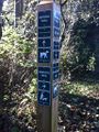
| + | Image:Rex-Vancouver-2013-10-28-3.JPG | That fence could get in my way. | ||
| + | Image:Rex-Vancouver-2013-10-28-4.JPG | Leaving Imperial for Hemlock. | ||
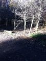
| + | Image:Rex-Vancouver-2013-10-28-5.JPG | I decide to leave the trail here... | ||
| + | Image:Rex-Vancouver-2013-10-28-6.JPG | The sign is posted! | ||
| + | Image:Rex-Vancouver-2013-10-28-7.JPG | Mugging for the camera. | ||
| + | Image:Rex-Vancouver-2013-10-28-8.JPG | That would have been a lot easier... | ||
| + | Image:2013-10-28_49-123_1.jpg | Rhonda on the hash, by Wijnland | ||
| + | Image:2013-10-28_49-123_2.jpg | Wijnlands super vague GPS pic. | ||
</gallery> | </gallery> | ||
| Line 65: | Line 88: | ||
{{#vardefine:ribbonwidth|800px}} | {{#vardefine:ribbonwidth|800px}} | ||
<!-- Add any achievement ribbons you earned below, or remove this section --> | <!-- Add any achievement ribbons you earned below, or remove this section --> | ||
| + | {{Earliest geohasher | ||
| + | | latitude = 49 | ||
| + | | longitude = -123 | ||
| + | | date = 2013-10-28 | ||
| + | | name = Rex | ||
| + | | image = Rex-Vancouver-2013-10-28-7.JPG | ||
| − | + | }} | |
| − | |||
| − | |||
| − | |||
<!-- An actual expedition: --> | <!-- An actual expedition: --> | ||
[[Category:Expeditions]] | [[Category:Expeditions]] | ||
| − | |||
[[Category:Expeditions with photos]] | [[Category:Expeditions with photos]] | ||
| − | |||
| − | |||
| − | |||
| − | |||
<!-- if you reached your coords: --> | <!-- if you reached your coords: --> | ||
[[Category:Coordinates reached]] | [[Category:Coordinates reached]] | ||
| − | + | {{location|CA|BC|MV}} | |
| − | |||
| − | |||
| − | |||
| − | |||
| − | |||
| − | |||
| − | |||
| − | |||
| − | |||
| − | |||
| − | |||
| − | |||
| − | |||
| − | |||
| − | |||
| − | |||
| − | |||
Latest revision as of 00:02, 10 August 2020
| Have you seen our geohashing marker? We'd love to hear from you! Click here to say "hi" and tell us what you've seen!
Curious about what geohashing is? Read more! |
| Mon 28 Oct 2013 in Vancouver: 49.2502425, -123.2109648 geohashing.info google osm bing/os kml crox |
Location
Pacific Spirit Regional Park, just east of Hemlock Trail.
Participants
Plans
this one is so easy it has to be done. I will go after work around 17.30 Wijnland (talk) 12:19, 28 October 2013 (EDT)
Saw the hash this morning, determined to cut some time out of work to go and tramp out into the brush! Rex Wolf (talk) 18:22, 28 October 2013 (EDT)
Expedition
Rex
I spooled out from my work site in downtown and headed for the hashpoint. Yeah, I'm playing hooky, but it's for a good cause. :) There's a nice place to park along the trail, at the intersection of Imperial, King Edward, and 29th. Covered in leaves, but then a lot of thing are covered with leaves at this time of year.
There's also more people out today than I had expected. People and dogs, mostly. I guess that makes sense, though--Imperial is a leash-optional trail in the winter months, and most of the people I see are taking advantage of that to walk their dogs off-leash. I also pass a quartet of runners who are running uphill along the trail, stopping, walking back downhill, and then jogging back uphill again. More power to them, I dare say.
I chug along the trail at a pretty good pace, making note of a sign pointing out that this is a habitat for "stream creatures." I'm not sure why, but that phrase tickles my fancy. A moment later, however, and I start growing concerned as I note that there's a wire fence along the trail. I have no idea how far it goes, this being my first time in this park, but it could be bothersome.
Fortunately, when Hemlock splits off of Imperial, the fence doesn't continue along. That's probably because Hemlock is a leash-required trail. Which may also be why nobody's on this trail.
I walk along for a bit, noticing some very nice openings off into the bush. Fool that I am, I decide to push further up the trail, to minimize the amount of time I spend in the brush. Which leads me into pushing through many brambles, some of what I swear is wild blackberry tendrils, and lots of dried ferns playing host to spiderwebs aplenty. Gack! But I manage to follow my GPS compass and twirl my way into a copse of trees where the brush seems to be less prevalent. When my GPS tells me that the haspoint is suddenly behind me, I know I've managed to reach my destination. Somewhere out here, anyways.
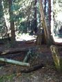
I tack up my sign, mug a Stupid Grin™ for the camera, and then start thinking about how to exit back to the trail. I don't particularly want to go blundering back along the path I took in here, and I notice a wonderful, mostly clear path under the trees, heading back in the direction of the trail. I get this sinking feeling that this is the "longer" path that I passed up earlier. Sure enough, it is. I feel remarkably silly.
And then I remember that I forgot to take a screenshot of my GPS showing valid coordinates. Stuff and bother!
Wijnland
Went to the hash after work ~ 17.30, it was an easy find with rexs marker already there. When I came out I met Rhonda and went for another quick trip into the woods. We hiked out together and went our ways.
Rhonda
Transit all the way across town took a while, and then I ended up on the wrong trail and going past the point, looping around, and approaching from the south, slightly after 5:30. Though, if I hadn't taken the wrong trail, I probably would have been there slightly before 5:30 as I had planned. The trail passed within about 50m of the point, and at the closest approach there was a bike just behind a bush, out of sight of the trail. Not just any bike, but a bike that hadn't been there for very long! That must be how Wijnland got here!
I started pushing through the thick underbrush, but had only got about 10m when Wijnland showed up, at the trail. As usual, there was an easier way out, so I backed out of the thick underbrush and followed Wijnland a little ways down the trail and into a remarkably open section of forest that went all the way to a laminated hashpoint marker. By the time we were on the marked trail system heading for the road it was starting to get dark, which is completely expected for after 5:30 in late October.
Tracklog
Photos
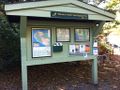
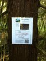
The info board at the trailhead.
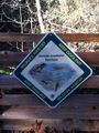
Stream creatures!
That fence could get in my way.
Leaving Imperial for Hemlock.
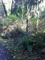
I decide to leave the trail here...
The sign is posted!

Mugging for the camera.
That would have been a lot easier...

Rhonda on the hash, by Wijnland
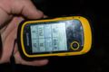
Wijnlands super vague GPS pic.


Achievements
Rex earned the Earliest geohasher achievement
|