Difference between revisions of "2013-11-03 47 -122"
imported>Thomcat ([live picture] Geohasher [http://www.openstreetmap.org/?lat=47.57002044&lon=-122.32189156&zoom=16&layers=B000FTF @47.5700,-122.3219]) |
imported>FippeBot m (Location) |
||
| (3 intermediate revisions by one other user not shown) | |||
| Line 13: | Line 13: | ||
== Participants == | == Participants == | ||
* [[User:Thomcat|Thomcat]] | * [[User:Thomcat|Thomcat]] | ||
| − | * [[User:AeroIllini|AeroIllini]] | + | * [[User:AeroIllini|AeroIllini]] pre-scouted |
| − | |||
== Plans == | == Plans == | ||
| Line 20: | Line 19: | ||
== Expedition == | == Expedition == | ||
| − | + | Two late goals in the soccer game at Judkins Park turned a win into a loss, unfortunately. | |
| − | + | A quick dash up to Dearborn and over to Airport Way leads me straight down to the geohash. Looped past the second building and spotted a trailer - AeroIllini says he lives close but I doubt it's this close. Looped back and drove to the hash point. | |
| − | + | ||
| + | A 12 minute wait until the 3pm, so we broke out the sidewalk chalk. I snapped a few pictures (and one was snapped of me) while the soccer star worked on some artwork. This hash point is near a freeway and one of the major east-west thoroughfares, and elevated viaduct called Spokane Street. This means overpass over top of overpass - some true aerial structures. I just hope I'm not on one when the big earthquake happens. | ||
| + | |||
| + | 3pm and no AeroIllini - so I snapped a final picture of the artwork. Your challenge - name that pony! | ||
== Photos == | == Photos == | ||
| Line 36: | Line 38: | ||
Image:2013-11-03_47_-122_14-59-50-242.jpg | Geohasher [http://www.openstreetmap.org/?lat=47.57002044&lon=-122.32189156&zoom=16&layers=B000FTF @47.5700,-122.3219] | Image:2013-11-03_47_-122_14-59-50-242.jpg | Geohasher [http://www.openstreetmap.org/?lat=47.57002044&lon=-122.32189156&zoom=16&layers=B000FTF @47.5700,-122.3219] | ||
| + | |||
| + | Image:2013-11-03_47_-122_15-04-36-794.jpg | Guess that pony [http://www.openstreetmap.org/?lat=47.57010271&lon=-122.32193955&zoom=16&layers=B000FTF @47.5701,-122.3219] | ||
</gallery> | </gallery> | ||
| − | |||
| − | |||
| − | |||
| − | |||
| − | |||
| − | |||
| − | |||
| − | |||
[[Category:Expeditions]] | [[Category:Expeditions]] | ||
| − | |||
[[Category:Expeditions with photos]] | [[Category:Expeditions with photos]] | ||
| − | |||
| − | |||
| − | |||
| − | |||
| − | |||
[[Category:Coordinates reached]] | [[Category:Coordinates reached]] | ||
| − | + | {{location|US|WA|KN}} | |
| − | |||
| − | |||
| − | |||
| − | |||
| − | |||
| − | |||
| − | |||
| − | |||
| − | |||
| − | |||
| − | |||
| − | |||
| − | |||
| − | |||
| − | |||
| − | |||
| − | |||
Latest revision as of 04:33, 14 August 2019
| Sun 3 Nov 2013 in Seattle: 47.5701598, -122.3219450 geohashing.info google osm bing/os kml crox |
Location
Just behind an industrial building in the SODO neighborhood.
Participants
- Thomcat
- AeroIllini pre-scouted
Plans
Meetup at 3pm (Pacific Standard Time)
Expedition
Two late goals in the soccer game at Judkins Park turned a win into a loss, unfortunately.
A quick dash up to Dearborn and over to Airport Way leads me straight down to the geohash. Looped past the second building and spotted a trailer - AeroIllini says he lives close but I doubt it's this close. Looped back and drove to the hash point.
A 12 minute wait until the 3pm, so we broke out the sidewalk chalk. I snapped a few pictures (and one was snapped of me) while the soccer star worked on some artwork. This hash point is near a freeway and one of the major east-west thoroughfares, and elevated viaduct called Spokane Street. This means overpass over top of overpass - some true aerial structures. I just hope I'm not on one when the big earthquake happens.
3pm and no AeroIllini - so I snapped a final picture of the artwork. Your challenge - name that pony!
Photos

Post-soccer geohash @47.5702,-122.3219
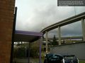
Overpasses galore @47.5702,-122.3219

Geohasher @47.5700,-122.3219
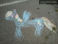
Guess that pony @47.5701,-122.3219


