Difference between revisions of "2013-11-06 33 -83"
From Geohashing
imported>Tomkf61 (Created page with "{{subst:Expedition |lat = 33 |lon = -83 |date = 2013-11-06}}") |
imported>Tomkf61 |
||
| Line 19: | Line 19: | ||
== Location == | == Location == | ||
<!-- where you've surveyed the hash to be --> | <!-- where you've surveyed the hash to be --> | ||
| − | + | Wooded area off Hill St, Loganville, behind hardware store. | |
== Participants == | == Participants == | ||
<!-- who attended: If you link to your wiki user name in this section, your expedition will be picked up by the various statistics generated for geohashing. You may use three tildes ~ as a shortcut to automatically insert the user signature of the account you are editing with. | <!-- who attended: If you link to your wiki user name in this section, your expedition will be picked up by the various statistics generated for geohashing. You may use three tildes ~ as a shortcut to automatically insert the user signature of the account you are editing with. | ||
--> | --> | ||
| − | + | *[[User:tomkf61|tomkf61]] | |
== Plans == | == Plans == | ||
<!-- what were the original plans --> | <!-- what were the original plans --> | ||
| − | + | Wasn't planning on geohashing today until I saw that today's hash was only 8 kilometers away. I seemed too easy. So I decided to try for two in one day, the other being Vidalia, GA 32 -82. | |
== Expedition == | == Expedition == | ||
<!-- how it all turned out. your narrative goes here. --> | <!-- how it all turned out. your narrative goes here. --> | ||
| + | Made the short drive to Hill Street and parked just past a traffic sign. There is virtually no traffic on this street. Found the hash in a thicket of scrubby pine trees behind the hardware store. Snapped a few pictures then got out. Stopped by to see friends at Holy Cross Anglican Church as I was two blocks away. | ||
| − | + | Then, off to 32, -82. | |
| − | |||
| − | |||
== Photos == | == Photos == | ||
<!-- Insert pictures between the gallery tags using the following format: | <!-- Insert pictures between the gallery tags using the following format: | ||
| Line 38: | Line 37: | ||
--> | --> | ||
<gallery perrow="5"> | <gallery perrow="5"> | ||
| + | File:2013-11-06 33 -83 01 HCAC.JPG | Beautiful church nearby | ||
| + | File:2013-11-06 33 -83 02 Hill St 2.JPG | View to Hill St from hash | ||
| + | File:2013-11-06 33 -83 03 Hill St GPS.JPG | Snap of GPS | ||
| + | File:2013-11-06 33 -83 04 US78 Hill St Intersect.JPG | Nearby intersection | ||
| + | |||
</gallery> | </gallery> | ||
| Line 43: | Line 47: | ||
{{#vardefine:ribbonwidth|800px}} | {{#vardefine:ribbonwidth|800px}} | ||
<!-- Add any achievement ribbons you earned below, or remove this section --> | <!-- Add any achievement ribbons you earned below, or remove this section --> | ||
| − | + | {{Multihash | latitude1 = 33 | longitude1 = -83 | latitude2 = 32 | longitude2 = -82 | date = 2013-11-06 | name = Tomkf61 }} | |
| − | |||
| − | |||
| − | |||
| − | |||
| − | |||
| − | |||
| − | |||
| − | |||
| − | |||
| − | |||
| − | |||
[[Category:Expeditions]] | [[Category:Expeditions]] | ||
| − | |||
[[Category:Expeditions with photos]] | [[Category:Expeditions with photos]] | ||
| − | |||
| − | |||
| − | |||
| − | |||
| − | |||
[[Category:Coordinates reached]] | [[Category:Coordinates reached]] | ||
| − | |||
| − | |||
| − | |||
| − | |||
| − | |||
| − | |||
| − | |||
| − | |||
| − | |||
| − | |||
| − | |||
| − | |||
| − | |||
| − | |||
| − | |||
| − | |||
| − | |||
| − | |||
Revision as of 06:13, 7 November 2013
| Wed 6 Nov 2013 in 33,-83: 33.8527026, -83.9197188 geohashing.info google osm bing/os kml crox |
Location
Wooded area off Hill St, Loganville, behind hardware store.
Participants
Plans
Wasn't planning on geohashing today until I saw that today's hash was only 8 kilometers away. I seemed too easy. So I decided to try for two in one day, the other being Vidalia, GA 32 -82.
Expedition
Made the short drive to Hill Street and parked just past a traffic sign. There is virtually no traffic on this street. Found the hash in a thicket of scrubby pine trees behind the hardware store. Snapped a few pictures then got out. Stopped by to see friends at Holy Cross Anglican Church as I was two blocks away.
Then, off to 32, -82.
Photos
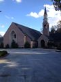
Beautiful church nearby
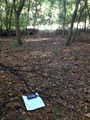
View to Hill St from hash
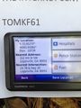
Snap of GPS
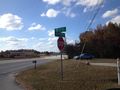
Nearby intersection


Achievements
Tomkf61 earned the Multihash Achievement
|