Difference between revisions of "2013-11-10 47 -122"
imported>Rex Wolf (Added expedition report) |
imported>Rex Wolf (Added images and tracklog.) |
||
| Line 44: | Line 44: | ||
== Tracklog == | == Tracklog == | ||
<!-- if your GPS device keeps a log, you may post a link here --> | <!-- if your GPS device keeps a log, you may post a link here --> | ||
| + | [[:Image:Rex-Seattle-2013-11-10-tracklog.png|Rex's tracklog as PNG.]] | ||
== Photos == | == Photos == | ||
| Line 50: | Line 51: | ||
--> | --> | ||
<gallery perrow="5"> | <gallery perrow="5"> | ||
| + | Image:Rex-Seattle-2013-11-10-1.JPG | Going by the Tacoma Dome. | ||
| + | Image:Rex-Seattle-2013-11-10-2.JPG | Why are hashpoints always located in such a tangle? | ||
| + | Image:Rex-Seattle-2013-11-10-3.JPG | The sign is posted! | ||
| + | Image:Rex-Seattle-2013-11-10-4.JPG | Mugshot. | ||
| + | Image:Rex-Seattle-2013-11-10-5.PNG | GPS readout. | ||
</gallery> | </gallery> | ||
| − | |||
== Achievements == | == Achievements == | ||
{{#vardefine:ribbonwidth|800px}} | {{#vardefine:ribbonwidth|800px}} | ||
| Line 61: | Line 66: | ||
| partner = his partner | | partner = his partner | ||
| name = [[User:Rex Wolf|Rex]] | | name = [[User:Rex Wolf|Rex]] | ||
| − | + | | image = Rex-Seattle-2013-11-10-2.JPG | |
}} | }} | ||
Revision as of 17:14, 13 November 2013
| Have you seen our geohashing marker? We'd love to hear from you! Click here to say "hi" and tell us what you've seen!
Curious about what geohashing is? Read more! |
| Sun 10 Nov 2013 in Seattle: 47.0623886, -122.8278696 geohashing.info google osm bing/os kml crox |
Location
In a wood on the corner of Abernethy Rd NE and 20th Way NE, north of Lacey.
Participants
Plans
Don't know when we're going to be there, but I'm planning on going sometime! Rex Wolf (talk) 13:19, 8 November 2013 (EST)
Expedition
We did indeed drive out to the hashpoint, a little earlier than I had anticipated. (This was a good thing, since we ended up going out to the Olympic hashpoint as well right after!)
Hashpoint turned out to be located in some woods, all right. So far, all "woods" I've planned on entering have turned out to be crowded and choked with underbrush, so I'm going to have to start planning on that from now on. There was a simple bar gate across the way, but only meant to keep out vehicles. It looks kind of like a cell site might be a little bit to the west of the hashpoint, but we didn't go nosing around to figure that out.
We got some very odd looks upon stumbling out of the underbrush from a local who seemed to be out walking his dog. Hazard of geohashing!
Tracklog
Photos
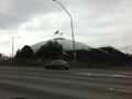
Going by the Tacoma Dome.
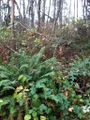
Why are hashpoints always located in such a tangle?
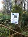
The sign is posted!
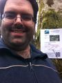
Mugshot.
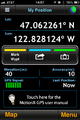
GPS readout.


Achievements
Rex earned the Drag-along achievement
|