Difference between revisions of "2013-11-12 47 10"
imported>LeslieHapablap ([live] Hi) |
imported>FippeBot m (Location) |
||
| (29 intermediate revisions by one other user not shown) | |||
| Line 9: | Line 9: | ||
And DON'T FORGET to add your expedition and the best photo you took to the gallery on the Main Page! We'd love to read your report, but that means we first have to discover it! :) | And DON'T FORGET to add your expedition and the best photo you took to the gallery on the Main Page! We'd love to read your report, but that means we first have to discover it! :) | ||
--> | --> | ||
| + | [[File:20131112 153005.jpg|left|900px]] | ||
{{meetup graticule | {{meetup graticule | ||
| lat=47 | | lat=47 | ||
| Line 14: | Line 15: | ||
| date=2013-11-12 | | date=2013-11-12 | ||
}} | }} | ||
| − | + | {{ClearLeft}} | |
<!-- edit as necessary --> | <!-- edit as necessary --> | ||
__NOTOC__ | __NOTOC__ | ||
== Location == | == Location == | ||
<!-- where you've surveyed the hash to be --> | <!-- where you've surveyed the hash to be --> | ||
| − | + | In a swamp near Dollinger, Imst. | |
== Participants == | == Participants == | ||
<!-- who attended: If you link to your wiki user name in this section, your expedition will be picked up by the various statistics generated for geohashing. You may use three tildes ~ as a shortcut to automatically insert the user signature of the account you are editing with. | <!-- who attended: If you link to your wiki user name in this section, your expedition will be picked up by the various statistics generated for geohashing. You may use three tildes ~ as a shortcut to automatically insert the user signature of the account you are editing with. | ||
--> | --> | ||
| + | * [[User:EleanorAbernathy|EleanorAbernathy]] | ||
| + | * [[User:LeslieHapablap|LeslieHapablap]] ([[2013-10-26 47 11|previous]]|[[2013-11-22 48 11|next]]) | ||
== Plans == | == Plans == | ||
<!-- what were the original plans --> | <!-- what were the original plans --> | ||
| − | + | Coming from Germany via the Fern Pass, the plan was to take a 6 min. detour on our way to Innsbruck via Imst instead of Mieming and pick up an easy hashpoint. But as you know, with geohashing you sign up for surprises. On the satellite image it looked like the point was surrounded by meadows and fields, although the area itself didn't seem to be cultivated. We were about to find out why. | |
== Expedition == | == Expedition == | ||
<!-- how it all turned out. your narrative goes here. --> | <!-- how it all turned out. your narrative goes here. --> | ||
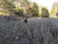
| + | [[Image:2013-11-12_47_10_23-59-45-061.jpg|300px|thumb|left|Perfect habitat for alligators.]] | ||
| + | Unfortunately this time the occasion for our visit to Germany was a dolorous one. Geohashing on our way back to Innsbruck on this quite chilly but charming November day was kind of a welcome opportunity to take our minds off things. | ||
| + | |||
| + | After roughly four hours of driving we arrived in Dollinger, a tiny settlement with only a few houses. We tried to keep a low profile but must have been very conspicuous to the locals who were standing at their garden fences chatting: two Germans (easily recognizable from the accent as soon as we say "hello") arriving in a car with Innsbruck license plate, wandering off to nowhere, smart phone in hand, and returning shortly after with wet feet and muddy cloths. We saw a few cats, one playing with a mouse (well the cat was playing, the mouse was struggling for survival), but none of them cared enough to come closer and award us with the [[hashcat achievement]]. | ||
| + | |||
| + | The reason for the wet feet: mother nature decided to present us with an extended swamp surrounding the coordinates. The area was covered with reed, and as soon as we arrived at the boarder of the marsh with 90 m to go to the coordinates, [[User:EleanorAbernathy|EleanorAbernathy]] was somehow reluctant to continue and exclaimed "Where these things grow you will be standing ankle deep in water soon!". And she was right of course. But in my we-have-come-this-far-blindness I spotted a path which looked reasonably dry and made my way into the vegetation. Trying hard to avoid erroneous steps into puddles of mud and water on both sides it felt a bit like Gollum finding the way through the dead marshes, of course without the Nazgûl chasing us. I'm sure there were plenty of alligators all around us, although strangely enough we didn't see any. | ||
| + | We crossed a small creek, and of course each of us made steps into water now and then accompanied by shrieking and curses. By the time we arrived at the hashpoint our feet were thoroughly wet, but this couldn't dampen our spirit. We did what we had to do at this yet another random location, including stupidly grinning into the camera, and waded back the same way. | ||
| − | |||
== Tracklog == | == Tracklog == | ||
<!-- if your GPS device keeps a log, you may post a link here --> | <!-- if your GPS device keeps a log, you may post a link here --> | ||
| Line 40: | Line 49: | ||
--> | --> | ||
<gallery perrow="5"> | <gallery perrow="5"> | ||
| + | |||
| + | Image:2013-11-12_47_10_23-55-02-941.jpg | Welcome to Dollinger. | ||
| + | |||
| + | Image:2013-11-12_47_10_23-55-45-664.jpg | Nice ponies. | ||
| + | |||
| + | Image:2013-11-12_47_10_23-56-39-434.jpg | Ponies being curious. There might be carrots! | ||
| + | |||
| + | Image:2013-11-12_47_10_00-07-46-148.jpg | Gollum leading the way. | ||
| + | |||
| + | Image:2013-11-12_47_10_23-57-45-510.jpg | Wading through the swamp. | ||
| + | |||
| + | Image:2013-11-12_47_10_23-58-25-234.jpg | Obligatory silly grin. | ||
| + | |||
| + | Image:2013-11-12_47_10_23-59-04-373.jpg | Obligatory proof. | ||
| + | |||
| + | Image:2013-11-12_47_10_23-59-45-061.jpg | There might be alligators! | ||
| + | |||
| + | Image:2013-11-12_47_10_00-01-10-711.jpg | Wet and muddy. | ||
| + | |||
| + | Image:2013-11-12_47_10_00-08-18-503.jpg | More wet feet. | ||
</gallery> | </gallery> | ||
| Line 45: | Line 74: | ||
{{#vardefine:ribbonwidth|800px}} | {{#vardefine:ribbonwidth|800px}} | ||
<!-- Add any achievement ribbons you earned below, or remove this section --> | <!-- Add any achievement ribbons you earned below, or remove this section --> | ||
| + | {{land geohash | ||
| + | |||
| + | | latitude = 47 | ||
| + | | longitude = 10 | ||
| + | | date = 2013-11-12 | ||
| + | | name = [[User:EleanorAbernathy|EleanorAbernathy]] and [[User:LeslieHapablap|LeslieHapablap]] | ||
| + | |||
| + | }} | ||
| + | {{gratuitous ribbon | ||
| + | |||
| + | | color = blue | ||
| + | | icon = Alligator.png | ||
| + | | latitude = 47 | ||
| + | | longitude = 10 | ||
| + | | date = 2013-11-12 | ||
| + | | achievement = There might be alligators! achievement | ||
| + | | description = geohashing in a swamp at the | ||
| + | | name = [[User:EleanorAbernathy|EleanorAbernathy]] and [[User:LeslieHapablap|LeslieHapablap]] | ||
| + | }} | ||
| + | {{Minesweeper geohash | ||
| + | |||
| + | | graticule = Kempten, Germany | ||
| + | | ranknumber = 3 | ||
| + | | ne = true | ||
| + | | e = true | ||
| + | | nw = true | ||
| + | | name = [[User:LeslieHapablap|LeslieHapablap]] | ||
| + | |||
| + | }} | ||
| + | {{Minesweeper geohash | ||
| + | |||
| + | | graticule = München, Germany | ||
| + | | ranknumber = 2 | ||
| + | | s = true | ||
| + | | sw = true | ||
| + | | name = [[User:LeslieHapablap|LeslieHapablap]] | ||
| + | |||
| + | }} | ||
| + | {{Minesweeper geohash | ||
| + | |||
| + | | graticule = Innsbruck, Austria | ||
| + | | ranknumber = 2 | ||
| + | | w = true | ||
| + | | n = true | ||
| + | | name = [[User:LeslieHapablap|LeslieHapablap]] | ||
| + | |||
| + | }} | ||
| + | {{Minesweeper geohash | ||
| + | |||
| + | | graticule = Kempten, Germany | ||
| + | | ranknumber = 2 | ||
| + | | e = true | ||
| + | | nw = true | ||
| + | | name = [[User:EleanorAbernathy|EleanorAbernathy]] | ||
| + | |||
| + | }} | ||
| + | {{Minesweeper geohash | ||
| + | |||
| + | | graticule = Stuttgart, Germany | ||
| + | | ranknumber = 1 | ||
| + | | se = true | ||
| + | | name = [[User:EleanorAbernathy|EleanorAbernathy]], [[User:LeslieHapablap|LeslieHapablap]] | ||
| + | |||
| + | }} | ||
| + | {{Minesweeper geohash | ||
| + | |||
| + | | graticule = Innsbruck, Austria | ||
| + | | ranknumber = 1 | ||
| + | | w = true | ||
| + | | name = [[User:EleanorAbernathy|EleanorAbernathy]] | ||
| + | |||
| + | }} | ||
<!-- =============== USEFUL CATEGORIES FOLLOW ================ | <!-- =============== USEFUL CATEGORIES FOLLOW ================ | ||
Delete the next line ONLY if you have chosen the appropriate categories below. If you are unsure, don't worry. People will read your report and help you with the classification. --> | Delete the next line ONLY if you have chosen the appropriate categories below. If you are unsure, don't worry. People will read your report and help you with the classification. --> | ||
| − | |||
<!-- Potential categories. Please include all the ones appropriate to your expedition --> | <!-- Potential categories. Please include all the ones appropriate to your expedition --> | ||
| Line 63: | Line 163: | ||
[[Category:Expedition without GPS]] | [[Category:Expedition without GPS]] | ||
--> | --> | ||
| + | [[Category:Expeditions]] | ||
| + | [[Category:Expeditions with photos]] | ||
| + | [[Category:Coordinates reached]] | ||
<!-- if you reached your coords: | <!-- if you reached your coords: | ||
| Line 84: | Line 187: | ||
(Don't forget to delete this final close comment marker) --> | (Don't forget to delete this final close comment marker) --> | ||
| + | {{location|AT|T|IM}} | ||
Latest revision as of 04:38, 14 August 2019

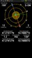
| Tue 12 Nov 2013 in 47,10: 47.2741173, 10.7888744 geohashing.info google osm bing/os kml crox |
Location
In a swamp near Dollinger, Imst.
Participants
Plans
Coming from Germany via the Fern Pass, the plan was to take a 6 min. detour on our way to Innsbruck via Imst instead of Mieming and pick up an easy hashpoint. But as you know, with geohashing you sign up for surprises. On the satellite image it looked like the point was surrounded by meadows and fields, although the area itself didn't seem to be cultivated. We were about to find out why.
Expedition

Unfortunately this time the occasion for our visit to Germany was a dolorous one. Geohashing on our way back to Innsbruck on this quite chilly but charming November day was kind of a welcome opportunity to take our minds off things.
After roughly four hours of driving we arrived in Dollinger, a tiny settlement with only a few houses. We tried to keep a low profile but must have been very conspicuous to the locals who were standing at their garden fences chatting: two Germans (easily recognizable from the accent as soon as we say "hello") arriving in a car with Innsbruck license plate, wandering off to nowhere, smart phone in hand, and returning shortly after with wet feet and muddy cloths. We saw a few cats, one playing with a mouse (well the cat was playing, the mouse was struggling for survival), but none of them cared enough to come closer and award us with the hashcat achievement.
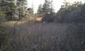
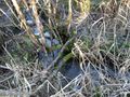
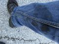
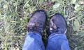
The reason for the wet feet: mother nature decided to present us with an extended swamp surrounding the coordinates. The area was covered with reed, and as soon as we arrived at the boarder of the marsh with 90 m to go to the coordinates, EleanorAbernathy was somehow reluctant to continue and exclaimed "Where these things grow you will be standing ankle deep in water soon!". And she was right of course. But in my we-have-come-this-far-blindness I spotted a path which looked reasonably dry and made my way into the vegetation. Trying hard to avoid erroneous steps into puddles of mud and water on both sides it felt a bit like Gollum finding the way through the dead marshes, of course without the Nazgûl chasing us. I'm sure there were plenty of alligators all around us, although strangely enough we didn't see any.
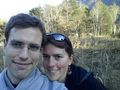
We crossed a small creek, and of course each of us made steps into water now and then accompanied by shrieking and curses. By the time we arrived at the hashpoint our feet were thoroughly wet, but this couldn't dampen our spirit. We did what we had to do at this yet another random location, including stupidly grinning into the camera, and waded back the same way.
Tracklog
Photos
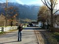
Welcome to Dollinger.
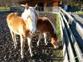
Nice ponies.
Ponies being curious. There might be carrots!
Gollum leading the way.
Wading through the swamp.
Obligatory silly grin.
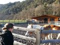
Obligatory proof.
There might be alligators!
Wet and muddy.
More wet feet.


Achievements
EleanorAbernathy and LeslieHapablap earned the Land geohash achievement
|
EleanorAbernathy and LeslieHapablap earned the There might be alligators! achievement
|
LeslieHapablap achieved level 3 of the Minesweeper Geohash achievement
|
LeslieHapablap achieved level 2 of the Minesweeper Geohash achievement
|
LeslieHapablap achieved level 2 of the Minesweeper Geohash achievement
|
EleanorAbernathy achieved level 2 of the Minesweeper Geohash achievement
|
EleanorAbernathy, LeslieHapablap achieved level 1 of the Minesweeper Geohash achievement
|
EleanorAbernathy achieved level 1 of the Minesweeper Geohash achievement
|