Difference between revisions of "2013-11-14 49 8"
imported>GeorgDerReisende (was wrong date in template repaired) |
imported>FippeBot m (Location) |
||
| (5 intermediate revisions by one other user not shown) | |||
| Line 13: | Line 13: | ||
| date=2013-11-14 | | date=2013-11-14 | ||
}} | }} | ||
| − | |||
__NOTOC__ | __NOTOC__ | ||
== Location == | == Location == | ||
| − | |||
| − | The hashpoint is located on a narrow meadow strip with apple trees north of [[wikipedia:Einhausen|Einhausen]]. | + | The hashpoint is located on a narrow meadow strip with apple trees north of [[wikipedia:Einhausen|Einhausen]] in the [[graticule|Graticule]] [[Mannheim, Germany|Mannheim (49, 8)]]. The blooming trees and the big one nexto the hashpoint are to be seen with Google Earth. |
== Participants == | == Participants == | ||
| Line 27: | Line 25: | ||
The weather was very cloudy but dry and I used the lunch break to go outdoors. | The weather was very cloudy but dry and I used the lunch break to go outdoors. | ||
| − | I reached the | + | I reached the meadow at 12:30. I took my boots because of the wet gras. The narrow but long meadow is a little natural reserve between the fields next to it. |
| − | + | The hashpoint is situated near the oldest and biggest tree. After I 'danced' a little, to find the best reading for a screenshot. Then I took some fotos, did a little diabolo juggling (see my [http://www.klicktipps.de/jonglieren-diabolo.php homepage]) and hurried back to work. | |
| − | |||
| − | The | ||
| − | I | + | I had not enough time to get to the final of the geocache [http://coord.info/GC27GXQ GC27GXQ] about 300 m from the hashpoint. |
| − | |||
| − | |||
| − | |||
| − | |||
| − | |||
| − | |||
| − | |||
== Photos == | == Photos == | ||
| − | |||
<!-- | <!-- | ||
Liste hochgeladener Dateien: | Liste hochgeladener Dateien: | ||
http://wiki.xkcd.com/wgh/index.php?title=Special%3AListFiles&limit=50&ilsearch=&user=Q-Owl | http://wiki.xkcd.com/wgh/index.php?title=Special%3AListFiles&limit=50&ilsearch=&user=Q-Owl | ||
<gallery perrow="5" > | <gallery perrow="5" > | ||
| − | --> | + | --> <gallery> |
| + | Image:2013-11-14_approach-kl.jpg | The meadow with the apple trees | ||
| + | Image:2013-11-14_screenshot-kl.jpg| Screenshot (Smartphone) | ||
| + | </gallery> | ||
| + | <gallery> | ||
| + | Image:2013-11-14_north-kl.jpg | North | ||
| + | Image:2013-11-14_east-kl.jpg | East | ||
| + | Image:2013-11-14_south-kl.jpg | South | ||
| + | Image:2013-11-14_west-kl.jpg | West | ||
| + | Image:2013-11-14_juggling-kl.jpg | Juggling (just before the grin) | ||
| + | </gallery> | ||
| + | <!-- | ||
| + | Liste hochgeladener Dateien: | ||
| + | http://wiki.xkcd.com/wgh/index.php?title=Special%3AListFiles&limit=50&ilsearch=&user=Q-Owl | ||
| + | <gallery perrow="5" > | ||
| + | --> | ||
== Achievements / Honorable Mention == | == Achievements / Honorable Mention == | ||
| + | {{#vardefine:ribbonwidth|600px}} | ||
{{land geohash | {{land geohash | ||
| latitude = 49 | | latitude = 49 | ||
| Line 82: | Line 86: | ||
[[Category:Coordinates reached]] | [[Category:Coordinates reached]] | ||
[[Category:Expeditions with photos]] | [[Category:Expeditions with photos]] | ||
| + | {{location|DE|HE|HP}} | ||
Latest revision as of 04:39, 14 August 2019
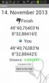
| Thu 14 Nov 2013 in 49,8: 49.6794005, 8.5480693 geohashing.info google osm bing/os kml crox |
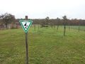
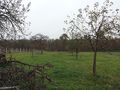
Location
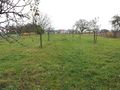
The hashpoint is located on a narrow meadow strip with apple trees north of Einhausen in the Graticule Mannheim (49, 8). The blooming trees and the big one nexto the hashpoint are to be seen with Google Earth.
Participants
Expedition
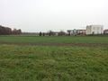
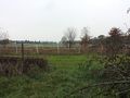
The weather was very cloudy but dry and I used the lunch break to go outdoors. I reached the meadow at 12:30. I took my boots because of the wet gras. The narrow but long meadow is a little natural reserve between the fields next to it.
The hashpoint is situated near the oldest and biggest tree. After I 'danced' a little, to find the best reading for a screenshot. Then I took some fotos, did a little diabolo juggling (see my homepage) and hurried back to work.
I had not enough time to get to the final of the geocache GC27GXQ about 300 m from the hashpoint.
Photos
The meadow with the apple trees
Screenshot (Smartphone)


North
East
South
West
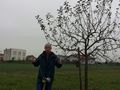
Juggling (just before the grin)


Achievements / Honorable Mention
Q-Owl earned the Land geohash achievement
|
Q-Owl earned the Circus Geohash Achievement
|