Difference between revisions of "2013-11-15 52 5"
imported>Palmpje m |
imported>FippeBot m (Location) |
||
| (10 intermediate revisions by one other user not shown) | |||
| Line 18: | Line 18: | ||
== Location == | == Location == | ||
<!-- where you've surveyed the hash to be --> | <!-- where you've surveyed the hash to be --> | ||
| + | Near the Hulshorsterzand on the Veluwe | ||
== Participants == | == Participants == | ||
<!-- who attended: If you link to your wiki user name in this section, your expedition will be picked up by the various statistics generated for geohashing. You may use three tildes ~ as a shortcut to automatically insert the user signature of the account you are editing with. | <!-- who attended: If you link to your wiki user name in this section, your expedition will be picked up by the various statistics generated for geohashing. You may use three tildes ~ as a shortcut to automatically insert the user signature of the account you are editing with. | ||
--> | --> | ||
| + | [[User:Palmpje|Palmpje]] is definitely willing to go there. | ||
== Plans == | == Plans == | ||
<!-- what were the original plans --> | <!-- what were the original plans --> | ||
| + | Start multi stage geocache [http://www.geocaching.com/geocache/GC1D677_sporen-aan-de-hemel-1-april-1943-avro-lancaster GC1D677] around 11:30 (at the designated parking spot). The hashpoint should be on the route. | ||
| + | |||
| + | Added after the expedition: My home graticule hashpoint was at Schiphol Airport. An exit off a main runway. Of course I could have booked a flight and back home but the probability of taxi-ing through this particular point is about 0.001% (or less!). This runway is mostly used for northbound tak-offs and southbound landings so a taxiway at the north end is hardly ever used. Therefore I decided to look at neighbouring graticules and 52, 5 looked very promising. OK, drive 100km to get this one (and do a cache or two). | ||
== Expedition == | == Expedition == | ||
<!-- how it all turned out. your narrative goes here. --> | <!-- how it all turned out. your narrative goes here. --> | ||
| + | I arrived half an hour later than planned. Mostly because I completely lost my way driving to the starting point of the hike. I guess I should have exited the A28 motorway 1 exit later... | ||
| + | |||
| + | When I finally got there I started the geocache [http://www.geocaching.com/geocache/GC1D677_sporen-aan-de-hemel-1-april-1943-avro-lancaster GC1D677] and at waypoint 4 (out of 10) I felt lost... This is not on a path in the forest and the listing clearly states to stay on the path. Well, this always happens to me. Luckily, I was only challenged by figuring out what was wrong with the single digit I had. So only 9 more options! After I decided on the best feasible one things went well... until I had to locate the geocache. It was near the monument shown in the pictures. During WWII an English bomber was shot down and it crashed about 1km from today's hashpoint. No hash collission for me today! | ||
| + | Anyway after some trial and error I located the geocache and proceeded to find the far more interesting hashpoint. I was somewhat dismayed as there was extensive forestry work going on in the vicinity and not sure about being able to reach the hashpoint. In fact... the sign I saw marked the path to the hashpoint as being closed. However, if I had not accidentally ventured that way.... I would not have seen the sign! And the path was not marked as closed. So I walked the final 200m to the hashpoint.... that was situated in a poodle made by giant forestry machines. Put up a marker a few meters away as I did not want to leave a marker there (might be trespassing!) | ||
| + | |||
| + | Al in all, a great November forest walk. Nice temperature (10 degrees Celcius) and no wind. It felt so great that I did another multi-cache. | ||
== Tracklog == | == Tracklog == | ||
| Line 37: | Line 48: | ||
--> | --> | ||
<gallery perrow="5"> | <gallery perrow="5"> | ||
| + | Image:2013_11_15_52_05_Uh-Oh.JPG | Can I get there? | ||
| + | Image:2013_11_15_52_05_Distance.JPG | Less than 200m, no barriers, no signs! | ||
| + | Image:2013_11_15_52_05_Proof.JPG | Made it! | ||
| + | Image:2013_11_15_52_05_Marker.JPG | Marker 4 meters from the spot | ||
| + | Image:2013_11_15_52_05_View1.JPG | Looking left | ||
| + | Image:2013_11_15_52_05_View3.JPG | Looking right | ||
| + | Image:2013_11_15_52_05_View2.JPG | Looking ahead | ||
| + | Image:2013_11_15_52_05_View4.JPG | Looking back | ||
| + | Image:2013_11_15_52_05_Tracks.JPG | No raptors, but this is a EU size 44 shoe! | ||
| + | Image:2013_11_15_52_05_Monument.JPG | Site of WWII bomber crash, less than 1 km from the hashpoint | ||
</gallery> | </gallery> | ||
| Line 42: | Line 63: | ||
{{#vardefine:ribbonwidth|800px}} | {{#vardefine:ribbonwidth|800px}} | ||
<!-- Add any achievement ribbons you earned below, or remove this section --> | <!-- Add any achievement ribbons you earned below, or remove this section --> | ||
| + | Yes! Made into another graticule... | ||
| + | {{Minesweeper geohash | graticule = Amsterdam, Netherlands | ranknumber = 1 | e = true | name = Palmpje }} | ||
| + | {{land geohash | latitude = 52 | longitude = 5 | date = 2013-11-15 | name = Palmpje }} | ||
| − | |||
| − | |||
| − | |||
| − | |||
| − | |||
| − | |||
| − | |||
| − | |||
| − | |||
| − | |||
| − | |||
[[Category:Expeditions]] | [[Category:Expeditions]] | ||
| − | |||
[[Category:Expeditions with photos]] | [[Category:Expeditions with photos]] | ||
| − | |||
| − | |||
| − | |||
| − | |||
| − | |||
[[Category:Coordinates reached]] | [[Category:Coordinates reached]] | ||
| − | + | {{location|NL|GE}} | |
| − | |||
| − | |||
| − | |||
| − | |||
| − | |||
| − | |||
| − | |||
| − | |||
| − | |||
| − | |||
| − | |||
| − | |||
| − | |||
| − | |||
| − | |||
| − | |||
| − | |||
Latest revision as of 04:39, 14 August 2019
| Fri 15 Nov 2013 in 52,5: 52.3270098, 5.7426153 geohashing.info google osm bing/os kml crox |
Location
Near the Hulshorsterzand on the Veluwe
Participants
Palmpje is definitely willing to go there.
Plans
Start multi stage geocache GC1D677 around 11:30 (at the designated parking spot). The hashpoint should be on the route.
Added after the expedition: My home graticule hashpoint was at Schiphol Airport. An exit off a main runway. Of course I could have booked a flight and back home but the probability of taxi-ing through this particular point is about 0.001% (or less!). This runway is mostly used for northbound tak-offs and southbound landings so a taxiway at the north end is hardly ever used. Therefore I decided to look at neighbouring graticules and 52, 5 looked very promising. OK, drive 100km to get this one (and do a cache or two).
Expedition
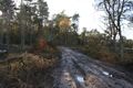
I arrived half an hour later than planned. Mostly because I completely lost my way driving to the starting point of the hike. I guess I should have exited the A28 motorway 1 exit later...
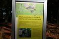
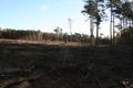
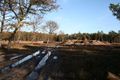
When I finally got there I started the geocache GC1D677 and at waypoint 4 (out of 10) I felt lost... This is not on a path in the forest and the listing clearly states to stay on the path. Well, this always happens to me. Luckily, I was only challenged by figuring out what was wrong with the single digit I had. So only 9 more options! After I decided on the best feasible one things went well... until I had to locate the geocache. It was near the monument shown in the pictures. During WWII an English bomber was shot down and it crashed about 1km from today's hashpoint. No hash collission for me today! Anyway after some trial and error I located the geocache and proceeded to find the far more interesting hashpoint. I was somewhat dismayed as there was extensive forestry work going on in the vicinity and not sure about being able to reach the hashpoint. In fact... the sign I saw marked the path to the hashpoint as being closed. However, if I had not accidentally ventured that way.... I would not have seen the sign! And the path was not marked as closed. So I walked the final 200m to the hashpoint.... that was situated in a poodle made by giant forestry machines. Put up a marker a few meters away as I did not want to leave a marker there (might be trespassing!)
Al in all, a great November forest walk. Nice temperature (10 degrees Celcius) and no wind. It felt so great that I did another multi-cache.
Tracklog
Photos
Can I get there?
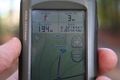
Less than 200m, no barriers, no signs!
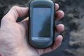
Made it!
Marker 4 meters from the spot
Looking left
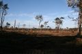
Looking right
Looking ahead
Looking back
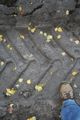
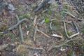
No raptors, but this is a EU size 44 shoe!
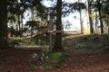
Site of WWII bomber crash, less than 1 km from the hashpoint


Achievements
Yes! Made into another graticule...
Palmpje achieved level 1 of the Minesweeper Geohash achievement
|
Palmpje earned the Land geohash achievement
|