Difference between revisions of "2013-11-22 46 7"
imported>Crox (→ThrOneRing) |
imported>FippeBot m (Location) |
||
| (8 intermediate revisions by 3 users not shown) | |||
| Line 1: | Line 1: | ||
| + | {{Advert | image = 2013-11-22_46_7_poster_zoom-IMG_2740.jpg }} | ||
<!-- If you did not specify these parameters in the template, please substitute appropriate values for IMAGE, LAT, LON, and DATE (YYYY-MM-DD format) | <!-- If you did not specify these parameters in the template, please substitute appropriate values for IMAGE, LAT, LON, and DATE (YYYY-MM-DD format) | ||
| Line 21: | Line 22: | ||
== Participants == | == Participants == | ||
| − | * [[user:crox|Crox]] | + | * [[user:crox|Crox]] |
| − | * [[user:TheOneRing|TheOneRing]] | + | * [[user:TheOneRing|TheOneRing]] |
== Plans == | == Plans == | ||
=== Crox === | === Crox === | ||
| − | ETA | + | ETA 17:20 - 17:30 CET |
=== ThrOneRing === | === ThrOneRing === | ||
| Line 35: | Line 36: | ||
== Expedition == | == Expedition == | ||
| − | + | === TheOneRing === | |
| + | After quite some time, a geohash was again located in the city of Bern. It was only 1.4km from home and I walked there. | ||
| + | |||
| + | I arrived around 17:15 CET and waited for Crox, while taking some photographs. We had a little chat and he placed the marker on a tree. | ||
| + | |||
| + | === Crox === | ||
| + | Crox arrived at 17:20 CET and TheOneRing was already there. | ||
== Tracklog == | == Tracklog == | ||
| Line 45: | Line 52: | ||
--> | --> | ||
<gallery perrow="5"> | <gallery perrow="5"> | ||
| + | Image:2013-11-22_46_7_poster-IMG_2740.jpg | We left a [[User:Crox/Poster|poster]] | ||
| + | Image:20131122_46_7GPS.jpg|Coordinates reached | ||
| + | Image:20131122_46_7Me.jpg|TheOneRing | ||
| + | Image:20131122_46_7Surrounding1.jpg|Schlossstrasse, eastwards | ||
| + | Image:20131122_46_7Surrounding2.jpg|Schlossstrasse, westwards | ||
</gallery> | </gallery> | ||
| Line 50: | Line 62: | ||
{{#vardefine:ribbonwidth|800px}} | {{#vardefine:ribbonwidth|800px}} | ||
<!-- Add any achievement ribbons you earned below, or remove this section --> | <!-- Add any achievement ribbons you earned below, or remove this section --> | ||
| + | {{land geohash | latitude = 46 | longitude = 7 | date = 2013-11-22 | name = TheOneRing and Crox}} | ||
| + | {{Walk geohash | latitude = 46 | longitude = 7 | date = 2013-11-22 | name = [[User:TheOneRing|TheOneRing]]}} | ||
| + | {{Public transport geohash | latitude = 46 | longitude = 7 | date = 2013-11-22 | name = [[User:Crox|Crox]]}} | ||
<!-- =============== USEFUL CATEGORIES FOLLOW ================ | <!-- =============== USEFUL CATEGORIES FOLLOW ================ | ||
| − | |||
| − | |||
| − | |||
| − | |||
| − | |||
--> | --> | ||
| − | |||
| − | |||
| − | |||
| − | |||
[[Category:Expeditions]] | [[Category:Expeditions]] | ||
| − | |||
[[Category:Expeditions with photos]] | [[Category:Expeditions with photos]] | ||
| − | |||
| − | |||
| − | |||
| − | |||
| − | |||
[[Category:Coordinates reached]] | [[Category:Coordinates reached]] | ||
| − | + | {{location|CH|BE}} | |
| − | |||
| − | |||
| − | |||
| − | |||
| − | |||
| − | |||
| − | |||
| − | |||
| − | |||
| − | |||
| − | |||
| − | |||
| − | |||
| − | |||
| − | |||
| − | |||
| − | |||
Latest revision as of 04:43, 14 August 2019
| Have you seen our geohashing marker? We'd love to hear from you! Click here to say "hi" and tell us what you've seen!
Curious about what geohashing is? Read more! |  |
| Fri 22 Nov 2013 in 46,7: 46.9443124, 7.4157302 geohashing.info google osm bing/os kml crox |
Location
Next to Schlossmatte tram stop (lines 7 and 8), Bern, Switzerland
Participants
Plans
Crox
ETA 17:20 - 17:30 CET
ThrOneRing
I think I'll need 30min to the geohash by foot; another opportunity for a Walk geohash. EDIT 15:45 UTC: I start in a couple of minutes and expect to arrive around 16:15 UTC.
> Crox: I'll try to make it by 17:30 then.
Expedition
TheOneRing
After quite some time, a geohash was again located in the city of Bern. It was only 1.4km from home and I walked there.
I arrived around 17:15 CET and waited for Crox, while taking some photographs. We had a little chat and he placed the marker on a tree.
Crox
Crox arrived at 17:20 CET and TheOneRing was already there.
Tracklog
Photos
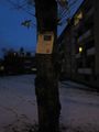
We left a poster
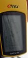
Coordinates reached

TheOneRing
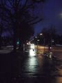
Schlossstrasse, eastwards
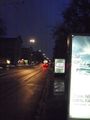
Schlossstrasse, westwards


Achievements
TheOneRing and Crox earned the Land geohash achievement
|
TheOneRing earned the Walk geohash Achievement
|
Crox earned the Public transport geohash achievement
|