Difference between revisions of "2013-12-25 35 -118"
From Geohashing
imported>Bravissimo594 ([live picture] On the lookout for friends. [http://www.openstreetmap.org/?lat=35.06950000&lon=-118.08400000&zoom=16&layers=B000FTF @35.0695,-118.0840]) |
imported>Jiml m (Adjust result code and fix template coord) |
||
| Line 11: | Line 11: | ||
{{meetup graticule | {{meetup graticule | ||
| lat=35 | | lat=35 | ||
| − | | lon=- | + | | lon=-118 |
| date=2013-12-25 | | date=2013-12-25 | ||
}} | }} | ||
| − | + | ||
__NOTOC__ | __NOTOC__ | ||
== Location == | == Location == | ||
| − | + | ||
A point in the Mojave desert west of California City, probably accessible BLM land. | A point in the Mojave desert west of California City, probably accessible BLM land. | ||
== Participants == | == Participants == | ||
| − | + | ||
| − | |||
* [[User:Bravissimo594|Bravissimo594]] | * [[User:Bravissimo594|Bravissimo594]] | ||
* [[User:Boppy5|Boppy5]] | * [[User:Boppy5|Boppy5]] | ||
== Plans == | == Plans == | ||
| − | + | ||
Following a planned [[2013-12-25_35_-119|11:00am meetup]] in the [[Bakersfield,_California|Bakersfield graticule]], we will drive east through Tehachapi along State Route 58 to the eastern side of the Sierra Nevada range to a point in the desert west of California City. If all goes well, the dogs will get to play with another hare or two. I expect to arrive sometime close to 1:30pm. | Following a planned [[2013-12-25_35_-119|11:00am meetup]] in the [[Bakersfield,_California|Bakersfield graticule]], we will drive east through Tehachapi along State Route 58 to the eastern side of the Sierra Nevada range to a point in the desert west of California City. If all goes well, the dogs will get to play with another hare or two. I expect to arrive sometime close to 1:30pm. | ||
| Line 38: | Line 37: | ||
== Photos == | == Photos == | ||
| − | + | ||
| − | |||
| − | |||
<gallery perrow="5"> | <gallery perrow="5"> | ||
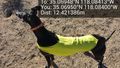
Image:2013-12-25_35_-118_14-38-49-292.jpg | Interference with the picnic. [http://www.openstreetmap.org/?lat=35.06950000&lon=-118.08400000&zoom=16&layers=B000FTF @35.0695,-118.0840] | Image:2013-12-25_35_-118_14-38-49-292.jpg | Interference with the picnic. [http://www.openstreetmap.org/?lat=35.06950000&lon=-118.08400000&zoom=16&layers=B000FTF @35.0695,-118.0840] | ||
| − | |||
Image:2013-12-25_35_-118_14-39-26-289.jpg | [http://www.openstreetmap.org/?lat=35.06950000&lon=-118.08400000&zoom=16&layers=B000FTF @35.0695,-118.0840] | Image:2013-12-25_35_-118_14-39-26-289.jpg | [http://www.openstreetmap.org/?lat=35.06950000&lon=-118.08400000&zoom=16&layers=B000FTF @35.0695,-118.0840] | ||
| − | |||
Image:2013-12-25_35_-118_14-40-06-679.jpg | Made it! [http://www.openstreetmap.org/?lat=35.06950439&lon=-118.08414434&zoom=16&layers=B000FTF @35.0695,-118.0841] | Image:2013-12-25_35_-118_14-40-06-679.jpg | Made it! [http://www.openstreetmap.org/?lat=35.06950439&lon=-118.08414434&zoom=16&layers=B000FTF @35.0695,-118.0841] | ||
| − | |||
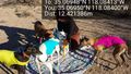
Image:2013-12-25_35_-118_14-50-53-425.jpg | On the lookout for friends. [http://www.openstreetmap.org/?lat=35.06950000&lon=-118.08400000&zoom=16&layers=B000FTF @35.0695,-118.0840] | Image:2013-12-25_35_-118_14-50-53-425.jpg | On the lookout for friends. [http://www.openstreetmap.org/?lat=35.06950000&lon=-118.08400000&zoom=16&layers=B000FTF @35.0695,-118.0840] | ||
</gallery> | </gallery> | ||
| Line 54: | Line 48: | ||
== Achievements == | == Achievements == | ||
{{#vardefine:ribbonwidth|800px}} | {{#vardefine:ribbonwidth|800px}} | ||
| − | |||
| + | * Land Geohash | ||
| − | |||
| − | |||
| − | |||
| − | |||
| − | |||
| − | |||
| − | |||
| − | |||
| − | |||
[[Category:Expeditions]] | [[Category:Expeditions]] | ||
| − | |||
[[Category:Expeditions with photos]] | [[Category:Expeditions with photos]] | ||
| − | |||
| − | |||
| − | |||
| − | |||
| − | |||
[[Category:Coordinates reached]] | [[Category:Coordinates reached]] | ||
| − | |||
| − | |||
| − | |||
| − | |||
| − | |||
| − | |||
| − | |||
| − | |||
| − | |||
| − | |||
| − | |||
| − | |||
| − | |||
| − | |||
| − | |||
| − | |||
| − | |||
| − | |||
Revision as of 03:44, 26 December 2013
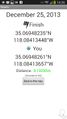
| Wed 25 Dec 2013 in 35,-118: 35.0694823, -118.0841345 geohashing.info google osm bing/os kml crox |
Location
A point in the Mojave desert west of California City, probably accessible BLM land.
Participants
Plans
Following a planned 11:00am meetup in the Bakersfield graticule, we will drive east through Tehachapi along State Route 58 to the eastern side of the Sierra Nevada range to a point in the desert west of California City. If all goes well, the dogs will get to play with another hare or two. I expect to arrive sometime close to 1:30pm.
Expedition
Tracklog
Photos
Interference with the picnic. @35.0695,-118.0840
Made it! @35.0695,-118.0841
On the lookout for friends. @35.0695,-118.0840


Achievements
- Land Geohash