Difference between revisions of "2013-12-25 35 -118"
imported>Bravissimo594 (→Tracklog) |
imported>Bravissimo594 |
||
| Line 1: | Line 1: | ||
| − | <!-- If you did not specify these parameters in the template, please substitute appropriate values for IMAGE, LAT, LON, and DATE (YYYY-MM-DD format) | + | <!-- If you did not specify these parameters in the template, please substitute appropriate values for IMAGE, LAT, LON, and DATE (YYYY-MM-DD format) --> |
| − | [[Image:{{{image| | + | [[Image:{{{image|2013-12-25_35_-118_14-50-53-425.jpg}}}|thumb|left]] |
| − | Remove this section if you don't want an image at the top (left) of your report. You should remove the "Image:" or "File:" | + | <!-- Remove this section if you don't want an image at the top (left) of your report. You should remove the "Image:" or "File:" |
tag from your image file name, and replace the all upper-case word IMAGE in the above line. | tag from your image file name, and replace the all upper-case word IMAGE in the above line. | ||
Revision as of 05:43, 26 December 2013

| Wed 25 Dec 2013 in 35,-118: 35.0694823, -118.0841345 geohashing.info google osm bing/os kml crox |
Location
A point in the Mojave desert west of California City -- BLM land.
Participants
Plans
Following a planned 11:00am meetup in the Bakersfield graticule, we will drive east through Tehachapi along State Route 58 to the eastern side of the Sierra Nevada range to a point in the desert west of California City. If all goes well, the dogs will get to play with another hare or two. I expect to arrive sometime close to 1:30pm.
Expedition
Bravissimo594
Sometime around noon, we left our successful expedition to the Bakersfield hashpoint for the day and headed up Bear Mountain Boulevard towards Tehachapi. We at first thought we might stop for lunch when passing through the mountain pass but then quickly remembered that it was Christmas Day and that most dining places would be closed.
We decided that we could continue to the meetup location, as we planned to picnic there anyway. So down the eastern slope we drove, around the north side of Mojave, and to the end of the pavement of Altus Road. Beyond the pavement, the road continued, and we turned to follow 20th Street and Arroyo Avenue, both of which are sandy packed dirt roads through the middle of the desert, with no houses, businesses, or any other structures nearby.
Arroyo Avenue brought us to within a couple of hundred meters of the meetup point, so we hiked our picnic blanket out through sparse brush and set up at the hash point. As in the earlier expedition in Bakersfield's graticule, the dogs found no hares to play with, but they still enjoyed the romp through the brush.
After eating and a short hike through the comfortable area, we packed up to try to make the Ridgecrest meetup point if possible before dark.
Photos
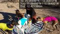
Interference with the picnic. @35.0695,-118.0840
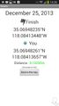
Made it! @35.0695,-118.0841
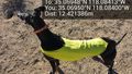
On the lookout for friends. @35.0695,-118.0840


Achievements
Boppy5 and Bravissimo594 earned the Land geohash achievement
|
Boppy5 and Bravissimo594 earned the Picnic achievement
|