2013-12-25 35 -118
From Geohashing
Revision as of 03:44, 26 December 2013 by imported>Jiml (Adjust result code and fix template coord)
| Wed 25 Dec 2013 in 35,-118: 35.0694823, -118.0841345 geohashing.info google osm bing/os kml crox |
Location
A point in the Mojave desert west of California City, probably accessible BLM land.
Participants
Plans
Following a planned 11:00am meetup in the Bakersfield graticule, we will drive east through Tehachapi along State Route 58 to the eastern side of the Sierra Nevada range to a point in the desert west of California City. If all goes well, the dogs will get to play with another hare or two. I expect to arrive sometime close to 1:30pm.
Expedition
Tracklog
Photos
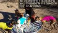
Interference with the picnic. @35.0695,-118.0840
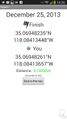
Made it! @35.0695,-118.0841
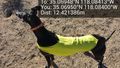
On the lookout for friends. @35.0695,-118.0840


Achievements
- Land Geohash