Difference between revisions of "2013-12-29 global"
imported>Wijnland |
imported>Wijnland |
||
| Line 1: | Line 1: | ||
| − | |||
| − | |||
| − | |||
| − | |||
| − | |||
| − | |||
| − | |||
| − | |||
| − | |||
| − | |||
{{meetup global|date=2013-12-29}} | {{meetup global|date=2013-12-29}} | ||
| Line 19: | Line 9: | ||
== Participants == | == Participants == | ||
[[User:Wijnland|Wijnland]] ([[User talk:Wijnland|talk]]) | [[User:Wijnland|Wijnland]] ([[User talk:Wijnland|talk]]) | ||
| − | |||
| − | |||
== Plans == | == Plans == | ||
<!-- what were the original plans --> | <!-- what were the original plans --> | ||
| − | + | [[User:Wijnland|Wijnland]] | |
This just has to be done! I have time and can drive my van up either this afternoon for a camp out, or tomorrow early for a day trip. In the middle of this break, we should be able to get a nice crew together | This just has to be done! I have time and can drive my van up either this afternoon for a camp out, or tomorrow early for a day trip. In the middle of this break, we should be able to get a nice crew together | ||
| Line 31: | Line 19: | ||
<!-- how it all turned out. your narrative goes here. --> | <!-- how it all turned out. your narrative goes here. --> | ||
| − | == | + | =The Full Report= |
| − | + | I`ll make this a report of all three geohashes attempted this day. I had lined up two normal hashes [[Vancouver, British Columbia]] and [[Cache Creek, British Columbia]] on my way to the [[Globalhash]] in | |
| + | [[Barrière, British Columbia]]. | ||
| + | |||
| + | The First location was not successful because of fences and no trespassing signs. I tried to approach from two sides, but the location was situation behind the airport and a reserve and under powerlines. | ||
| + | <gallery perrow="5"> | ||
| + | Image:Wiebe-06539.jpg | 1km to go from two sides | ||
| + | Image:Wiebe-06540.jpg | No trespassing | ||
| + | </gallery> | ||
| + | |||
| + | The second hash was a just of Hwy 1 between Cache Creek and Kamloops. I stopped on the side of the road in a little pull out and walked through the thinly snow covered fields to the point, snapped some pictures and on again to get as far as possible before nightfall. | ||
| + | <gallery perrow="5"> | ||
| + | Image:Wiebe-06543.jpg| Van Parked | ||
| + | Image:Wiebe-06547.jpg | Made It | ||
| + | Image:Wiebe-06556.jpg | Smile! | ||
| + | </gallery> | ||
| + | |||
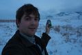
| + | Between just after that geohash I and kamloops I gave a ride to a nice hich-hiker, my good dead for the day!. Around Kamloops the weather started to get nasty, Snow, dense fog etc, but luckily it was much better when I arrived in Barriere. Still somewhat cold, but no snow or rain. It had gotten dark, but I did bring a flashlight and most of the route was on a good road that was not accessible by car in winter, but clearly marked. The last 200m or so was some bushwacking but not to difficult. The snow was easy enough to walk through. I made it to the hash around 8PM and back out an hour later. After that i got myself dinner and found a good place to park my van for the night in Clearwater. The next day I continued to Prince George which (Hwy 5 to hwy 16) which took quite long because of the snowy, icy, and slushy road conditions. I visided friends there for Newyears, not planned but made possible by crazy geohashing. | ||
| − | |||
| − | |||
| − | |||
| − | |||
<gallery perrow="5"> | <gallery perrow="5"> | ||
| + | Image:Wiebe-06567.jpg| as far as my van could take me | ||
| + | Image:Wiebe-06574.jpg | Made It GlobalHash! | ||
| + | Image:Wiebe-06576.jpg | Smile i the very dark... | ||
</gallery> | </gallery> | ||
| + | |||
| + | |||
| + | == Tracklog == | ||
| + | [[File:Geohash_20131229_global.jpg |200px|thumb|track to globalhash from Barriere]] | ||
| + | |||
== Achievements == | == Achievements == | ||
{{#vardefine:ribbonwidth|800px}} | {{#vardefine:ribbonwidth|800px}} | ||
<!-- Add any achievement ribbons you earned below, or remove this section --> | <!-- Add any achievement ribbons you earned below, or remove this section --> | ||
| + | {{globalhash | date = 2013-12-29 | name = Wijnland | image = Wiebe-06576.jpg }} | ||
| + | |||
| + | {{Multihash | ||
| + | | latitude1 = 49 | ||
| + | | longitude1 = -123 | ||
| + | | latitude2 = 51 | ||
| + | | longitude2 = -120 | ||
| + | | date = 2013-12-29 | ||
| + | | name = Wijnland | ||
| + | }} | ||
| + | |||
| + | {{No trespassing | ||
| + | | latitude = 49 | ||
| + | | longitude = -123 | ||
| + | | date = 2013-12-29 | ||
| + | | name = Wijnland | ||
| + | | image = Wiebe-06540.jpg | ||
| + | | distance = 1.3km | ||
| + | }} | ||
| + | |||
| Line 50: | Line 78: | ||
[[Category:New report]] | [[Category:New report]] | ||
| − | |||
| − | |||
| − | |||
| − | |||
| − | |||
[[Category:Expeditions]] | [[Category:Expeditions]] | ||
| − | |||
[[Category:Expeditions with photos]] | [[Category:Expeditions with photos]] | ||
| − | |||
[[Category:Expedition without GPS]] | [[Category:Expedition without GPS]] | ||
| − | |||
| − | |||
| + | [[Category: Meetup in 50 -121]] | ||
| + | [[Category: Globalhash]] | ||
[[Category:Coordinates reached]] | [[Category:Coordinates reached]] | ||
| − | + | [[Category: Meetup in 49 -123]] | |
| − | |||
[[Category:Coordinates not reached]] | [[Category:Coordinates not reached]] | ||
| − | |||
| − | |||
| − | |||
| − | |||
| − | |||
[[Category:Not reached - No public access]] | [[Category:Not reached - No public access]] | ||
| − | |||
| − | |||
| − | |||
| − | |||
| − | |||
| − | |||
| − | |||
| − | |||
Revision as of 05:39, 3 January 2014
|
Globalhash on Sun 29 Dec 2013: |
Location
Just North-East of Barriere, BC. Canada
Participants
Plans
Wijnland This just has to be done! I have time and can drive my van up either this afternoon for a camp out, or tomorrow early for a day trip. In the middle of this break, we should be able to get a nice crew together
Expedition
the short report (more later) I made it, got a no tresspass in squamish (vancouver grat) and succes in Grande Cache. I left much to late and only arrived to the globalhash around 8PM it was completely dark and the road conditions were not great. But hurrah a globalhash! went on to Prince George for a visit with some friends i was not planning to go see. will post the full report and pics when back in my home graticule.
The Full Report
I`ll make this a report of all three geohashes attempted this day. I had lined up two normal hashes Vancouver, British Columbia and Cache Creek, British Columbia on my way to the Globalhash in Barrière, British Columbia.
The First location was not successful because of fences and no trespassing signs. I tried to approach from two sides, but the location was situation behind the airport and a reserve and under powerlines.
1km to go from two sides
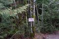
No trespassing


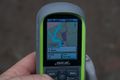
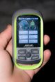
The second hash was a just of Hwy 1 between Cache Creek and Kamloops. I stopped on the side of the road in a little pull out and walked through the thinly snow covered fields to the point, snapped some pictures and on again to get as far as possible before nightfall.
Van Parked
Made It
Smile!


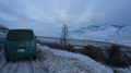
Between just after that geohash I and kamloops I gave a ride to a nice hich-hiker, my good dead for the day!. Around Kamloops the weather started to get nasty, Snow, dense fog etc, but luckily it was much better when I arrived in Barriere. Still somewhat cold, but no snow or rain. It had gotten dark, but I did bring a flashlight and most of the route was on a good road that was not accessible by car in winter, but clearly marked. The last 200m or so was some bushwacking but not to difficult. The snow was easy enough to walk through. I made it to the hash around 8PM and back out an hour later. After that i got myself dinner and found a good place to park my van for the night in Clearwater. The next day I continued to Prince George which (Hwy 5 to hwy 16) which took quite long because of the snowy, icy, and slushy road conditions. I visided friends there for Newyears, not planned but made possible by crazy geohashing.
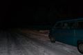
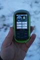
as far as my van could take me
Made It GlobalHash!

Smile i the very dark...


Tracklog

Achievements
Wijnland earned the Globalhash achievement
|
Wijnland earned the Multihash Achievement
|
Wijnland earned the No trespassing consolation prize
|