Difference between revisions of "2014-01-21 42 -85"
imported>Mcbaneg (→Photos) |
imported>Mcbaneg (→Photos) |
||
| Line 36: | Line 36: | ||
<gallery perrow="4"> | <gallery perrow="4"> | ||
Image:2014-01-21_42_-85_1.jpg| Speed limit sign, clearly reading 30 mph. | Image:2014-01-21_42_-85_1.jpg| Speed limit sign, clearly reading 30 mph. | ||
| − | Image:2014-01-21_42_-85_5.jpg| Shot of speedometer going past hashpoint, clinching Speed Racer. | + | Image:2014-01-21_42_-85_5.jpg| Shot of speedometer going past hashpoint, clinching Speed Racer. [If you squint you can sort of see a fuzzy diagonal line going roughly from the center of the dial to where 30 mph should be.] |
Image:2014-01-21_42_-85_3.jpg| Street sign at the corner of Richmond St. and Walker Ave, just west of hashpoint. Incontrovertible evidence that I got to the right place. | Image:2014-01-21_42_-85_3.jpg| Street sign at the corner of Richmond St. and Walker Ave, just west of hashpoint. Incontrovertible evidence that I got to the right place. | ||
Image:2014-01-21_42_-85_temp.jpg| Temperature record from nearby station KMIGRAND34, showing -11 °C at 6 pm. Yes, it's sad that the best pic I have was cropped from a Weather Underground screenshot. | Image:2014-01-21_42_-85_temp.jpg| Temperature record from nearby station KMIGRAND34, showing -11 °C at 6 pm. Yes, it's sad that the best pic I have was cropped from a Weather Underground screenshot. | ||
Revision as of 02:49, 22 January 2014
| Tue 21 Jan 2014 in 42,-85: 42.9931618, -85.7141845 geohashing.info google osm bing/os kml crox |
Location
North (westbound) side of Richmond St. by Holy Cross Cemetery, Grand Rapids, MI, USA
Participants
Expedition
Like 2014-01-02 42 -85, too easy not to go for: actually on a road, close to where the bus drops me during my commute home. This is just a little west of our first Michigan hash at 2013-08-17 42 -85.
Since it was actually on the road, and dark, and cold, I thought it best to go for (frozen) Speed Racer. Unfortunately my cell phone and I were not up to the photography task, so I have no usable pics to show. I drove westbound along Richmond St, and tried to shoot pictures of two 30-mph speed limit signs as I went along (white blurry rectangle), one shot of the graveyard (black), one of the speedometer showing 31 mph as I went by (unintelligible sea-anemone impression from lit dial and car vibration), and one shot of the street sign at the nearby intersection with Walker Ave(vague green blurry rectangle). So it's a total loss in the expedition-photos department.
Photos
Speed limit sign, clearly reading 30 mph.
Shot of speedometer going past hashpoint, clinching Speed Racer. [If you squint you can sort of see a fuzzy diagonal line going roughly from the center of the dial to where 30 mph should be.]
Street sign at the corner of Richmond St. and Walker Ave, just west of hashpoint. Incontrovertible evidence that I got to the right place.
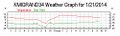
Temperature record from nearby station KMIGRAND34, showing -11 °C at 6 pm. Yes, it's sad that the best pic I have was cropped from a Weather Underground screenshot.


Achievements
George earned the Land geohash achievement
|
George earned the No Batteries Geohash Achievement
|
