Difference between revisions of "2014-01-22 43 -116"
From Geohashing
imported>Eldin (initial page creation) |
imported>FippeBot m (Location) |
||
| (2 intermediate revisions by 2 users not shown) | |||
| Line 1: | Line 1: | ||
| − | |||
| − | |||
| − | |||
| − | |||
| − | |||
| − | |||
| − | |||
| − | |||
| − | |||
| − | |||
{{meetup graticule | {{meetup graticule | ||
| lat=43 | | lat=43 | ||
| Line 15: | Line 5: | ||
}} | }} | ||
| − | |||
__NOTOC__ | __NOTOC__ | ||
| Line 23: | Line 12: | ||
== Participants == | == Participants == | ||
* [[User:Eldin|Eldin]] | * [[User:Eldin|Eldin]] | ||
| − | + | * [[User:Ojones|Ojones]] | |
| − | |||
| − | |||
== Expedition == | == Expedition == | ||
| + | '''Eldin''' | ||
The hash for today looked fairly easy to reach, so after work I headed out towards it. As expected, I was able to park my car within 50ft of the hash, and walk to it easily. At the hash, I snapped a few pictures, picked up some trash, and then headed back for home. | The hash for today looked fairly easy to reach, so after work I headed out towards it. As expected, I was able to park my car within 50ft of the hash, and walk to it easily. At the hash, I snapped a few pictures, picked up some trash, and then headed back for home. | ||
| + | '''Ojones''' | ||
| + | Easy hash today. Just off the side of the road. Got there around 6:15pm and took a couple pictures. | ||
== Photos == | == Photos == | ||
| − | |||
| − | |||
| − | |||
<gallery perrow="5"> | <gallery perrow="5"> | ||
| + | File:2014-01-22 43 -116 grin.jpg | Grinning geohasher. | ||
| + | File:2014-01-22 43 -116 proof.jpg | Proof the coordinates were reached. | ||
| + | File:2014-01-22 43 -116 geotrash.jpg | This plastic jug was almost right on the hashpoint. I dropped it a recycling bin on my way home. | ||
| + | File:2014-01-22 43 -116 temperature.jpg | Proof of freezing temperature. | ||
| + | File:2014-01-22 43 -116 train.jpg | Train that passed the hashpoint while I was there. Only the retroreflective portions showed up in the picture. | ||
| + | File:2014-01-22_43_-116_hashpoint.jpeg | Hashpoint in the dark. | ||
| + | File:2014-01-22 43 -116 grinning.jpg | [[User:Ojones|Ojones]] grinning. | ||
</gallery> | </gallery> | ||
| Line 45: | Line 39: | ||
{{Geotrash|latitude=43|longitude=-116|date=2014-01-22|name=[[User:Eldin|Eldin]]}} | {{Geotrash|latitude=43|longitude=-116|date=2014-01-22|name=[[User:Eldin|Eldin]]}} | ||
| − | |||
| − | |||
| − | |||
| − | |||
| − | |||
| − | |||
| − | |||
| − | |||
| − | |||
| − | |||
[[Category:Expeditions]] | [[Category:Expeditions]] | ||
| − | |||
[[Category:Expeditions with photos]] | [[Category:Expeditions with photos]] | ||
| − | |||
| − | |||
| − | |||
| − | |||
| − | |||
[[Category:Coordinates reached]] | [[Category:Coordinates reached]] | ||
| − | + | {{location|US|ID|AA}} | |
| − | |||
| − | |||
| − | |||
| − | |||
| − | |||
| − | |||
| − | |||
| − | |||
| − | |||
| − | |||
| − | |||
| − | |||
| − | |||
| − | |||
| − | |||
| − | |||
| − | |||
Latest revision as of 05:19, 14 August 2019
| Wed 22 Jan 2014 in 43,-116: 43.5097610, -116.4544739 geohashing.info google osm bing/os kml crox |
Location
In Kuna, just off Black Cat Rd.
Participants
Expedition
Eldin The hash for today looked fairly easy to reach, so after work I headed out towards it. As expected, I was able to park my car within 50ft of the hash, and walk to it easily. At the hash, I snapped a few pictures, picked up some trash, and then headed back for home.
Ojones Easy hash today. Just off the side of the road. Got there around 6:15pm and took a couple pictures.
Photos

Grinning geohasher.

Proof the coordinates were reached.
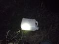
This plastic jug was almost right on the hashpoint. I dropped it a recycling bin on my way home.
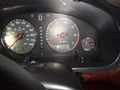
Proof of freezing temperature.

Train that passed the hashpoint while I was there. Only the retroreflective portions showed up in the picture.
Hashpoint in the dark.

Ojones grinning.


Achievements
Eldin earned the Land geohash achievement
|

Eldin earned the Frozen Geohash Achievement
by reaching the (43, -116) geohash on 2014-01-22 while the temperature was 23°F.
Eldin earned the GeoTrash Geohash Achievement
|