Difference between revisions of "2014-02-03 44 -123"
imported>Frogman (→Photos) |
imported>Frogman (→Achievements) |
||
| Line 60: | Line 60: | ||
[[Category:Expedition planning]] | [[Category:Expedition planning]] | ||
| − | |||
[[Category:Expeditions]] | [[Category:Expeditions]] | ||
| − | |||
[[Category:Expeditions with photos]] | [[Category:Expeditions with photos]] | ||
| − | |||
| − | |||
| − | |||
| − | |||
| − | |||
[[Category:Coordinates reached]] | [[Category:Coordinates reached]] | ||
| − | |||
| − | |||
| − | |||
| − | |||
| − | |||
| − | |||
| − | |||
| − | |||
| − | |||
| − | |||
| − | |||
| − | |||
| − | |||
| − | |||
| − | |||
| − | |||
| − | |||
| − | |||
Revision as of 03:47, 4 February 2014
| Mon 3 Feb 2014 in 44,-123: 44.6794904, -123.2483381 geohashing.info google osm bing/os kml crox |
Location
In a field west of Adair Village, Oregon.
Participants
Second Expedition
- Frogman
- Greg
Plans
I will probably bike up here after class. Frogman (talk) 13:29, 3 February 2014 (EST)
- Oh good. Michael5000 (talk) 16:43, 3 February 2014 (EST)
Expedition
Second Expedition
I was going to ride my bike to the hashpoint after class, but Greg offered to drive us there. This was great, because it was cold! We drove up Highway 99, only getting a bit lost once, and pulled into a gravel road to continue the rest of the way on foot. But why were there small rectangular pieces of paper in the gate? Michael5000 had been here already, it seems! We made remarks on how dedicated he must be, both to this sport and to showing us up, to have taken the drive down to Corvallis. And he didn't even visit!
The hashpoint itself was a short trek up the hill from there. The area was logged so we were met with fantastic views of the sunset.
Tracklog
Photos
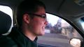
Driving to the hashpoint!
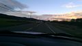
Highway 99.
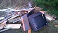
There was a pile of junk sitting close to where we parked.
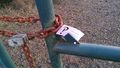
Someone got here first!
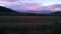
The view to the north of the hashpoint.
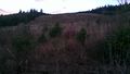
The view to the south, up a hill.
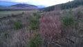
A flag was there, marking the hashpoint. Well, within GPS margin-of-error at least.

Expedition 2's goofy grins.


