Difference between revisions of "2014-02-15 34 -118"
From Geohashing
imported>Bravissimo594 (Added picture from Google Maps) |
imported>FippeBot m (Location) |
||
| (8 intermediate revisions by one other user not shown) | |||
| Line 1: | Line 1: | ||
| + | {{Advert | ||
| + | |image=2014-02-15 34 -118 marker.png}} | ||
<!-- If you did not specify these parameters in the template, please substitute appropriate values for IMAGE, LAT, LON, and DATE (YYYY-MM-DD format) --> | <!-- If you did not specify these parameters in the template, please substitute appropriate values for IMAGE, LAT, LON, and DATE (YYYY-MM-DD format) --> | ||
| Line 28: | Line 30: | ||
== Plans == | == Plans == | ||
<!-- what were the original plans --> | <!-- what were the original plans --> | ||
| − | Aiming for an | + | Aiming for an official 4:00pm Saturday meetup in this spot that is convenient to a million people. [[User:Bravissimo594|Bravissimo594]] ([[User talk:Bravissimo594|talk]]) 12:11, 14 February 2014 (EST) |
| + | |||
| + | == Poster == | ||
| + | [http://geo.crox.net/poster/2014-02-15_34_-118 PDF poster for this expedition]. Thanks to [[User:Crox/Poster]]. | ||
== Expedition == | == Expedition == | ||
<!-- how it all turned out. your narrative goes here. --> | <!-- how it all turned out. your narrative goes here. --> | ||
| + | |||
| + | *Arrived at 4:01pm, marked the spot with chalk, posted a marker, took pictures, and hung out for 15 minutes (not at all suspiciously) in case anyone else could make it, and then headed out. It was an easy trip on a pleasant afternoon. -- [[User:Bravissimo594|Bravissimo594]] ([[User talk:Bravissimo594|talk]]) [http://www.openstreetmap.org/?lat=34.08039751&lon=-118.09357936&zoom=16&layers=B000FTF @34.0804,-118.0936] 19:16, 15 February 2014 (EST) | ||
== Tracklog == | == Tracklog == | ||
<!-- if your GPS device keeps a log, you may post a link here --> | <!-- if your GPS device keeps a log, you may post a link here --> | ||
| Line 41: | Line 48: | ||
--> | --> | ||
<gallery perrow="5"> | <gallery perrow="5"> | ||
| + | |||
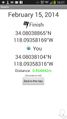
| + | Image:2014-02-15_34_-118_16-09-51-250.jpg | Success! Geohash Droid details. [http://www.openstreetmap.org/?lat=34.08041635&lon=-118.09360435&zoom=16&layers=B000FTF @34.0804,-118.0936] | ||
| + | |||
| + | Image:2014-02-15_34_-118_16-11-04-150.jpg | No one else here with whom to meet up. :-( [http://www.openstreetmap.org/?lat=34.08040000&lon=-118.09400000&zoom=16&layers=B000FTF @34.0804,-118.0940] | ||
| + | |||
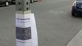
| + | Image:2014-02-15_34_-118_16-11-58-559.jpg | Sidewalk chalk comes in handy. [http://www.openstreetmap.org/?lat=34.08040000&lon=-118.09400000&zoom=16&layers=B000FTF @34.0804,-118.0940] | ||
| + | |||
| + | Image:2014-02-15_34_-118_16-12-41-806.jpg | Marker left nearby. [http://www.openstreetmap.org/?lat=34.08040000&lon=-118.09400000&zoom=16&layers=B000FTF @34.0804,-118.0940] | ||
</gallery> | </gallery> | ||
| Line 53: | Line 68: | ||
<!-- Potential categories. Please include all the ones appropriate to your expedition --> | <!-- Potential categories. Please include all the ones appropriate to your expedition --> | ||
| − | <!-- If this is a planning page: | + | <!-- If this is a planning page: |
[[Category:Expedition planning]] | [[Category:Expedition planning]] | ||
| + | --> | ||
| − | + | <!-- An actual expedition: --> | |
| − | <!-- An actual expedition: | ||
[[Category:Expeditions]] | [[Category:Expeditions]] | ||
| − | |||
[[Category:Expeditions with photos]] | [[Category:Expeditions with photos]] | ||
| − | [[Category:Expeditions with videos]] | + | <!-- [[Category:Expeditions with videos]] |
[[Category:Expedition without GPS]] | [[Category:Expedition without GPS]] | ||
--> | --> | ||
| − | <!-- if you reached your coords: | + | <!-- if you reached your coords: --> |
[[Category:Coordinates reached]] | [[Category:Coordinates reached]] | ||
| − | + | <!-- or if you failed :( | |
[[Category:Coordinates not reached]] | [[Category:Coordinates not reached]] | ||
-- and a reason -- | -- and a reason -- | ||
| Line 85: | Line 99: | ||
(Don't forget to delete this final close comment marker) --> | (Don't forget to delete this final close comment marker) --> | ||
| + | {{location|US|CA|LO}} | ||
Latest revision as of 05:31, 14 August 2019
| Have you seen our geohashing marker? We'd love to hear from you! Click here to say "hi" and tell us what you've seen!
Curious about what geohashing is? Read more! |  |

| Sat 15 Feb 2014 in 34,-118: 34.0803886, -118.0935817 geohashing.info google osm bing/os kml crox |
Location
Lafayette Street, near Valley Boulevard, in San Gabriel. Los Angeles graticule.
Participants
Plans
Aiming for an official 4:00pm Saturday meetup in this spot that is convenient to a million people. Bravissimo594 (talk) 12:11, 14 February 2014 (EST)
Poster
PDF poster for this expedition. Thanks to User:Crox/Poster.
Expedition
- Arrived at 4:01pm, marked the spot with chalk, posted a marker, took pictures, and hung out for 15 minutes (not at all suspiciously) in case anyone else could make it, and then headed out. It was an easy trip on a pleasant afternoon. -- Bravissimo594 (talk) @34.0804,-118.0936 19:16, 15 February 2014 (EST)
Tracklog
Photos
Success! Geohash Droid details. @34.0804,-118.0936

No one else here with whom to meet up. :-( @34.0804,-118.0940

Sidewalk chalk comes in handy. @34.0804,-118.0940
Marker left nearby. @34.0804,-118.0940


