Difference between revisions of "2014-02-21 47 -122"
imported>Thomcat |
imported>FippeBot m (Location) |
||
| (7 intermediate revisions by 2 users not shown) | |||
| Line 21: | Line 21: | ||
== Expedition == | == Expedition == | ||
| − | + | ||
| + | === Thomcat === | ||
No problems driving, but got a late start. First use of geohash android on the new phone, so had to login. Didn't get a great signal due to a moving truck. Took pictures but could not upload - 8M top big? Will investigate (and upload) once in Frankfurt. The Delta safety video is worth a chuckle. | No problems driving, but got a late start. First use of geohash android on the new phone, so had to login. Didn't get a great signal due to a moving truck. Took pictures but could not upload - 8M top big? Will investigate (and upload) once in Frankfurt. The Delta safety video is worth a chuckle. | ||
| + | *Here -- [[User:Thomcat|Thomcat]] ([[User talk:Thomcat|talk]]) [http://www.openstreetmap.org/?lat=47.60695731&lon=-122.32852911&zoom=16&layers=B000FTF @47.6070,-122.3285] 11:26, 21 February 2014 (PST) | ||
| + | |||
| + | Pictures below. Slightly longer version - after chalking the wall and waving to the movers (drop the couch right there boys, and let me take a seat) I headed back to the car through a light rain. As I tried a few times to get the pictures to upload, the rain turned to hail, so I snapped one more photo and left. Turns out my plane left at 1:20 not 1:50, so after racing through security I made it to the gate with just a minute or so to spare. Whew! | ||
| + | |||
| + | I haven't researched why geohashdroid wouldn't allow picture upload yet. Pending after other tasks, such as determining a Sunday meetup location. --[[User:Thomcat|Thomcat]] ([[User talk:Thomcat|talk]]) 15:20, 22 February 2014 (EST) | ||
| + | |||
| + | === OtherJack === | ||
| + | Between a late day at the office, drinks with friends after work and then food and company beckoning at home, I didn't end up starting towards the hash until around 10:30pm. Ride down was straightforward via Dexter/7th Ave to downtown, and then 8th Ave under the convention center and up First Hill... and the weather was much clearer than what Thomcat encountered. I even remembered to bring my real gps this time, thinking the tall buildings on either side of the little alley would give the android's gps a lot of trouble. | ||
| + | |||
| + | Unfortunately they were also a pain for the real gps... it took about 5 minutes to lock on, and then insisted the hash was well inside the locked and surveilled building to the east, even though its circle of error was nominally only 5 meters or so. Never showed a number closer than 11 meters. But then it started drifting a ton, and eventually just said "signal not good enough" or something. So I'll count this as reached given that I was in the spot depicted on the satellite picture. | ||
| + | It was a cool spot though - big view of the freeway and the downtown Seattle skyscrapers, as well as more humble First Hill buildings in the other direction, including a very artistic parking garage (if that's what it was?) for the Polyclinic across the street. I did not notice Thom's marker though... either it had been removed, it was too dark, or I just wasn't paying attention. | ||
| − | + | Ride home was also uneventful. Nice little late-night workout. | |
== Photos == | == Photos == | ||
| − | |||
| − | |||
| − | |||
<gallery perrow="5"> | <gallery perrow="5"> | ||
| + | |||
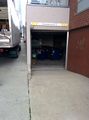
| + | Image:2014-02-21_47_-122_Moving_Truck.jpg | Moving Truck is parked on the hashpoint | ||
| + | Image:2014-02-21_47_-122_Marker.jpg | Convenient wall | ||
| + | Image:2014-02-21_47_-122_Geohasher.jpg | ||
| + | Image:2014-02-21_47_-122_Hail.jpg | ||
| + | Image:2014-02-21 22.55.54.jpg | Jack's failed proof attempt | ||
| + | Image:2014-02-21 22.56.37.jpg | I hope they don't track me down! | ||
| + | Image:2014-02-21 22.57.44.jpg | Colorful/odd garage exterior | ||
| + | Image:2014-02-21 22.58.06.jpg | ||
| + | Image:2014-02-21 22.58.16.jpg | Can you find the bike? | ||
| + | |||
</gallery> | </gallery> | ||
| Line 38: | Line 58: | ||
{{#vardefine:ribbonwidth|800px}} | {{#vardefine:ribbonwidth|800px}} | ||
<!-- Add any achievement ribbons you earned below, or remove this section --> | <!-- Add any achievement ribbons you earned below, or remove this section --> | ||
| + | {{Bicycle geohash | latitude = 47 | longitude = -122 | date = 2014-02-21 | name = [[User:OtherJack|OtherJack]] | distance = about 10 km each way}} | ||
| − | |||
| − | |||
| − | |||
| − | |||
[[Category:Expeditions]] | [[Category:Expeditions]] | ||
| − | |||
[[Category:Expeditions with photos]] | [[Category:Expeditions with photos]] | ||
| − | |||
| − | |||
| − | |||
| − | |||
| − | |||
[[Category:Coordinates reached]] | [[Category:Coordinates reached]] | ||
| − | + | {{location|US|WA|KN}} | |
| − | |||
| − | |||
| − | |||
| − | |||
| − | |||
| − | |||
| − | |||
| − | |||
| − | |||
| − | |||
| − | |||
| − | |||
| − | |||
| − | |||
| − | |||
| − | |||
| − | |||
Latest revision as of 05:34, 14 August 2019
| Fri 21 Feb 2014 in Seattle: 47.6071761, -122.3284704 geohashing.info google osm bing/os kml crox |
Location
Looks to be on a road or alley behind the Polyclinic in Seattle, just east of the Freeway.
Participants
Plans
Thom: Stop by on the way to the airport, roughly 11 am, then fly to Deutschland!
Jack: I gotta get this one too... will be in the evening definitely, I think either around 7:30 or perhaps even closer to a midnight hash. Open to other times if other people post.
Expedition
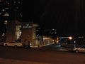
Thomcat
No problems driving, but got a late start. First use of geohash android on the new phone, so had to login. Didn't get a great signal due to a moving truck. Took pictures but could not upload - 8M top big? Will investigate (and upload) once in Frankfurt. The Delta safety video is worth a chuckle.
- Here -- Thomcat (talk) @47.6070,-122.3285 11:26, 21 February 2014 (PST)
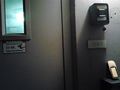
Pictures below. Slightly longer version - after chalking the wall and waving to the movers (drop the couch right there boys, and let me take a seat) I headed back to the car through a light rain. As I tried a few times to get the pictures to upload, the rain turned to hail, so I snapped one more photo and left. Turns out my plane left at 1:20 not 1:50, so after racing through security I made it to the gate with just a minute or so to spare. Whew!
I haven't researched why geohashdroid wouldn't allow picture upload yet. Pending after other tasks, such as determining a Sunday meetup location. --Thomcat (talk) 15:20, 22 February 2014 (EST)
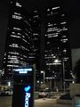
OtherJack
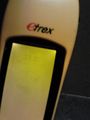
Between a late day at the office, drinks with friends after work and then food and company beckoning at home, I didn't end up starting towards the hash until around 10:30pm. Ride down was straightforward via Dexter/7th Ave to downtown, and then 8th Ave under the convention center and up First Hill... and the weather was much clearer than what Thomcat encountered. I even remembered to bring my real gps this time, thinking the tall buildings on either side of the little alley would give the android's gps a lot of trouble.
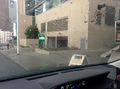
Unfortunately they were also a pain for the real gps... it took about 5 minutes to lock on, and then insisted the hash was well inside the locked and surveilled building to the east, even though its circle of error was nominally only 5 meters or so. Never showed a number closer than 11 meters. But then it started drifting a ton, and eventually just said "signal not good enough" or something. So I'll count this as reached given that I was in the spot depicted on the satellite picture.
It was a cool spot though - big view of the freeway and the downtown Seattle skyscrapers, as well as more humble First Hill buildings in the other direction, including a very artistic parking garage (if that's what it was?) for the Polyclinic across the street. I did not notice Thom's marker though... either it had been removed, it was too dark, or I just wasn't paying attention.
Ride home was also uneventful. Nice little late-night workout.
Photos
Moving Truck is parked on the hashpoint

Convenient wall

Jack's failed proof attempt
I hope they don't track me down!
Colorful/odd garage exterior
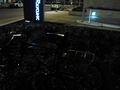
Can you find the bike?


Achievements
OtherJack earned the Bicycle geohash achievement
|