Difference between revisions of "2014-02-24 34 -118"
imported>Bravissimo594 (→Location: Named location.) |
imported>FippeBot m (Location) |
||
| (19 intermediate revisions by 2 users not shown) | |||
| Line 1: | Line 1: | ||
| + | {{Advert | ||
| + | |image=2014-02-24 34 -118-marker.png}} | ||
<!-- If you did not specify these parameters in the template, please substitute appropriate values for IMAGE, LAT, LON, and DATE (YYYY-MM-DD format) | <!-- If you did not specify these parameters in the template, please substitute appropriate values for IMAGE, LAT, LON, and DATE (YYYY-MM-DD format) | ||
| − | + | --> | |
| − | [[Image:{{{image| | + | [[Image:{{{image|2014-02-24 34 -118 20-35-06-055.jpg}}}|thumb|left]] |
| − | + | <!-- | |
Remove this section if you don't want an image at the top (left) of your report. You should remove the "Image:" or "File:" | Remove this section if you don't want an image at the top (left) of your report. You should remove the "Image:" or "File:" | ||
tag from your image file name, and replace the all upper-case word IMAGE in the above line. | tag from your image file name, and replace the all upper-case word IMAGE in the above line. | ||
| Line 15: | Line 17: | ||
}} | }} | ||
| − | + | ||
__NOTOC__ | __NOTOC__ | ||
== Location == | == Location == | ||
| − | + | ||
| − | On Woodward | + | On Woodward Avenue in Sunland/Tujunga. [[Los Angeles, California|Los Angeles]] graticule. |
== Participants == | == Participants == | ||
| − | + | ||
| − | + | * [[User:Bravissimo594|Bravissimo594]] | |
| + | * [[User:Boppy5|Boppy5]] | ||
== Plans == | == Plans == | ||
<!-- what were the original plans --> | <!-- what were the original plans --> | ||
| + | * If both [[User:Boppy5|Boppy5]] and [[User:Bravissimo594|I]] can make it to the point at about 2:45pm then that is when we will be there. Otherwise, it will be 8:00pm this evening. [[User:Bravissimo594|Bravissimo594]] ([[User talk:Bravissimo594|talk]]) 14:30, 24 February 2014 (EST) | ||
| + | :*Too tricky to coordinate with lunchtime, so we will try to make it to the site at 8:00pm this evening. [[User:Bravissimo594|Bravissimo594]] ([[User talk:Bravissimo594|talk]]) 15:50, 24 February 2014 (EST) | ||
| + | |||
| + | == Poster == | ||
| + | [http://geo.crox.net/poster/2014-02-24_34_-118 PDF poster for this expedition]. Thanks to [[User:Crox/Poster]]. | ||
== Expedition == | == Expedition == | ||
<!-- how it all turned out. your narrative goes here. --> | <!-- how it all turned out. your narrative goes here. --> | ||
| − | == | + | === [[User:Bravissimo594|Bravissimo594]] ([[User talk:Bravissimo594|talk]]) === |
| − | + | Success at 8:30pm! Once [[User:Boppy5|Boppy5]] and I were both done with our daytime tasks, we headed out, driving along I-210 to the Sunland/Tujunga area of Los Angeles. We arrived at the hashpoint, chalked the spot with an "X" and some "KCDs," placed a marker nearby, and took some photos. The late hour made the front-facing camera a bit dark in its photos. The hash point, being in the street right in front of Apperson Street Elementary School, gets plenty of traffic in the mornings and afternoons, but only one car passed by while we were there. | |
| + | |||
| + | Two dogs barked a few times in the fenced front yard of the house across the street from the school, but they did not pay as much attention to suspicious geohashers as I thought they would. But when a neighbor walked his dog past them, the two got so riled up that they seemed to get almost vicious with each other. They snarled, growled, and barked at each other so loudly and for so long that the owner (finally) came out to break them up. If it took that much noise to get the owner's attention then I bet the neighborhood often has to put up with quite a lot of barking on a regular basis. | ||
| + | |||
| + | To complete the adventure, we took a scenic route home, exploring neighborhoods that we had never visited before, including those along Apperson Street, Day Street, and Sky Ridge Drive. We got to see some audacious deer that could not care less that we were driving slowly past them as they picked clover out of someone's front lawn. | ||
| + | |||
| + | After all of the explorations, we made it back to base at about 9:30pm. | ||
== Photos == | == Photos == | ||
| − | + | ||
| − | |||
| − | |||
<gallery perrow="5"> | <gallery perrow="5"> | ||
| + | |||
| + | Image:2014-02-24_34_-118_20-35-06-055.jpg | Late night success. [http://www.openstreetmap.org/?lat=34.25540000&lon=-118.30700000&zoom=16&layers=B000FTF @34.2554,-118.3070] | ||
| + | Image:2014-02-24_34_-118_20-37-19-245.jpg | Geohash Droid. [http://www.openstreetmap.org/?lat=34.25542398&lon=-118.30710093&zoom=16&layers=B000FTF @34.2554,-118.3071] | ||
| + | Image:2014-02-24_34_-118_20-37-53-237.jpg | Street chalk. [http://www.openstreetmap.org/?lat=34.25540000&lon=-118.30700000&zoom=16&layers=B000FTF @34.2554,-118.3070] | ||
| + | Image:2014-02-24_34_-118_20-38-27-821.jpg | Marker nearby. [http://www.openstreetmap.org/?lat=34.25550000&lon=-118.30700000&zoom=16&layers=B000FTF @34.2555,-118.3070] | ||
| + | |||
</gallery> | </gallery> | ||
| Line 45: | Line 63: | ||
<!-- Add any achievement ribbons you earned below, or remove this section --> | <!-- Add any achievement ribbons you earned below, or remove this section --> | ||
| + | * Land geohash | ||
| − | |||
| − | |||
| − | |||
| − | + | [[Category:Expeditions]] | |
| − | |||
| − | |||
| − | |||
| − | [[Category: | ||
| − | |||
| − | + | [[Category:Expeditions with photos]] | |
| − | |||
| − | |||
| − | [[Category:Expeditions with photos]] | ||
| − | |||
| − | |||
| − | |||
| − | |||
| − | |||
[[Category:Coordinates reached]] | [[Category:Coordinates reached]] | ||
| − | + | {{location|US|CA|LO}} | |
| − | |||
| − | |||
| − | |||
| − | |||
| − | |||
| − | |||
| − | |||
| − | |||
| − | |||
| − | |||
| − | |||
| − | |||
| − | |||
| − | |||
| − | |||
| − | |||
| − | |||
Latest revision as of 05:38, 14 August 2019
| Have you seen our geohashing marker? We'd love to hear from you! Click here to say "hi" and tell us what you've seen!
Curious about what geohashing is? Read more! |  |

| Mon 24 Feb 2014 in 34,-118: 34.2554328, -118.3070486 geohashing.info google osm bing/os kml crox |
Location
On Woodward Avenue in Sunland/Tujunga. Los Angeles graticule.
Participants
Plans
- If both Boppy5 and I can make it to the point at about 2:45pm then that is when we will be there. Otherwise, it will be 8:00pm this evening. Bravissimo594 (talk) 14:30, 24 February 2014 (EST)
- Too tricky to coordinate with lunchtime, so we will try to make it to the site at 8:00pm this evening. Bravissimo594 (talk) 15:50, 24 February 2014 (EST)
Poster
PDF poster for this expedition. Thanks to User:Crox/Poster.
Expedition
Bravissimo594 (talk)
Success at 8:30pm! Once Boppy5 and I were both done with our daytime tasks, we headed out, driving along I-210 to the Sunland/Tujunga area of Los Angeles. We arrived at the hashpoint, chalked the spot with an "X" and some "KCDs," placed a marker nearby, and took some photos. The late hour made the front-facing camera a bit dark in its photos. The hash point, being in the street right in front of Apperson Street Elementary School, gets plenty of traffic in the mornings and afternoons, but only one car passed by while we were there.
Two dogs barked a few times in the fenced front yard of the house across the street from the school, but they did not pay as much attention to suspicious geohashers as I thought they would. But when a neighbor walked his dog past them, the two got so riled up that they seemed to get almost vicious with each other. They snarled, growled, and barked at each other so loudly and for so long that the owner (finally) came out to break them up. If it took that much noise to get the owner's attention then I bet the neighborhood often has to put up with quite a lot of barking on a regular basis.
To complete the adventure, we took a scenic route home, exploring neighborhoods that we had never visited before, including those along Apperson Street, Day Street, and Sky Ridge Drive. We got to see some audacious deer that could not care less that we were driving slowly past them as they picked clover out of someone's front lawn.
After all of the explorations, we made it back to base at about 9:30pm.
Photos
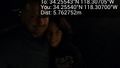
Late night success. @34.2554,-118.3070
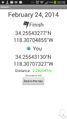
Geohash Droid. @34.2554,-118.3071
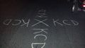
Street chalk. @34.2554,-118.3070
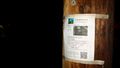
Marker nearby. @34.2555,-118.3070


Achievements
- Land geohash