Difference between revisions of "2014-03-07 51 13"
From Geohashing
imported>Oisín |
m (Location correction) |
||
| (4 intermediate revisions by 3 users not shown) | |||
| Line 15: | Line 15: | ||
}} | }} | ||
| − | + | ||
__NOTOC__ | __NOTOC__ | ||
== Location == | == Location == | ||
| − | + | ||
A small footpath at the border between the city of [http://en.wikipedia.org/wiki/Dresden Dresden] and [http://en.wikipedia.org/wiki/Radebeul Radebeul]. | A small footpath at the border between the city of [http://en.wikipedia.org/wiki/Dresden Dresden] and [http://en.wikipedia.org/wiki/Radebeul Radebeul]. | ||
== Participants == | == Participants == | ||
| − | + | ||
| − | + | * [[User:Oisín|Oisín]] | |
| − | [[User:Oisín|Oisín]] | ||
== Plans == | == Plans == | ||
| − | + | Since I first heard of Geohashing in November I hoped to get a location that was close to my normal ways to and from work. The first time the hash was close enough I didn't have the time to visit the location. Today I had some time to try my first expedition. | |
== Expedition == | == Expedition == | ||
| − | + | The weather was unusually warm for march and the sun was shining. It only took a small detour on my way home from work through a forest area in the north of Dresden. I parked my bike close to the location and enjoyed the sun. The whole trip was 15.1 km on bike. | |
| + | -- [[User:Oisín|Oisín]] [http://www.openstreetmap.org/?lat=51.10835133&lon=13.69360289&zoom=16 @51.1084,13.6936] 16:57, 7 March 2014 (CET) | ||
| − | + | <!-- == Tracklog == | |
| − | + | if your GPS device keeps a log, you may post a link here --> | |
| − | == Tracklog == | ||
| − | |||
== Photos == | == Photos == | ||
| Line 46: | Line 44: | ||
<!-- Add any achievement ribbons you earned below, or remove this section --> | <!-- Add any achievement ribbons you earned below, or remove this section --> | ||
| + | * Land geohash | ||
| − | |||
| − | |||
| − | |||
| − | |||
| − | + | [[Category:Expeditions]] | |
| − | |||
| − | [[Category: | ||
| − | |||
| − | |||
| − | |||
| − | |||
[[Category:Expeditions with photos]] | [[Category:Expeditions with photos]] | ||
| − | |||
| − | |||
| − | |||
| − | |||
| − | |||
| − | |||
| − | + | [[Category:Coordinates reached]] | |
| − | [[Category:Coordinates | + | {{location|DE|SN|MEI}} |
| − | |||
| − | |||
| − | |||
| − | |||
| − | |||
| − | |||
| − | |||
| − | |||
| − | |||
| − | |||
| − | |||
| − | |||
| − | |||
| − | |||
Latest revision as of 20:23, 16 May 2020
| Fri 7 Mar 2014 in 51,13: 51.1083237, 13.6936191 geohashing.info google osm bing/os kml crox |
Location
A small footpath at the border between the city of Dresden and Radebeul.
Participants
Plans
Since I first heard of Geohashing in November I hoped to get a location that was close to my normal ways to and from work. The first time the hash was close enough I didn't have the time to visit the location. Today I had some time to try my first expedition.
Expedition
The weather was unusually warm for march and the sun was shining. It only took a small detour on my way home from work through a forest area in the north of Dresden. I parked my bike close to the location and enjoyed the sun. The whole trip was 15.1 km on bike. -- Oisín @51.1084,13.6936 16:57, 7 March 2014 (CET)
Photos
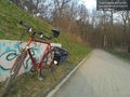
The place @51.1083,13.6936

Achievements
- Land geohash