Difference between revisions of "2014-03-11 47 -122"
imported>OtherJack (→Participants) |
imported>Stand (→Expedition) |
||
| Line 40: | Line 40: | ||
*Yay - geohashdroid working again! -- [[User:Thomcat|Thomcat]] ([[User talk:Thomcat|talk]]) [http://www.openstreetmap.org/?lat=47.79730270&lon=-122.20605690&zoom=16&layers=B000FTF @47.7973,-122.2061] 13:28, 11 March 2014 (PDT) | *Yay - geohashdroid working again! -- [[User:Thomcat|Thomcat]] ([[User talk:Thomcat|talk]]) [http://www.openstreetmap.org/?lat=47.79730270&lon=-122.20605690&zoom=16&layers=B000FTF @47.7973,-122.2061] 13:28, 11 March 2014 (PDT) | ||
| − | I had a 30 minute run scheduled for today and with the geohash only a mile from the house I had to reroute a bit so I could end up there. I took what I call the "boat route" because the | + | I had a 30 minute run scheduled for today and with the geohash only a mile from the house I had to reroute a bit so I could end up there. I took what I call the "boat route" because the [http://connect.garmin.com/activity/459355153 GPS track] looks a bit like the prow of a ship pointing west. I had to add some distance towards the end because I went too fast. I spent about 15 minutes at the site trying to get a picture of my watch displaying the coordinates. Alas, my phone camera isn't that good. I did upload a pic of the chalk "XKCD" on the street. That plus the my [http://connect.garmin.com/activity/459355153 GPS track] should be enough to prove I was there, eh? I think there's a badge for walking to a site so I'll have to check on that. --[[User:Stand|Stand]] ([[User talk:Stand|talk]]) 17:25, 11 March 2014 (EDT) |
== Tracklog == | == Tracklog == | ||
Revision as of 21:28, 11 March 2014
| Tue 11 Mar 2014 in Seattle: 47.6868412, -122.3840468 geohashing.info google osm bing/os kml crox |
Location
NW 80th Street in Ballard, between 21st and 22nd ave NW.
Participants
Plans
Revisit after work
This is on one of my normal running routes so I'll try to arrange to finish a run here over lunch. --Stand (talk) 12:19, 11 March 2014 (EDT)
- Look for chalk next to the center line. --Thomcat (talk) 12:23, 11 March 2014 (EDT)
- I think I'll also go for it "over lunch" (basically right now.) Evening would also work but likely after 8pm. Maybe I'll run into you Stan? About when is your ETA? For me will probably be 12:45 or so. -- OtherJack (talk) 15:19, 11 March 2014 (EDT)
Expedition
Was a few minutes from ready for work at 6:28 - might as well check the point before heading out the door. WARNING: Different DJIA values for 2014-03-11: 16419.39 (crox) / 0 (peeron). Using 16419.39. is never a good sign. Still, 2km south and 1km west of my house is worth an expedition.
Google maps shows it to be in the middle of 80th ave NW, near a favorite bakery called Larsens. Ballard is the Scandinavian portion of Seattle, from the Blessing of the Fleet (two days ago) to Syttende Mai. With some Swedish lineage, it was a natural place to call home.
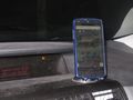
Out the door and on the way - what is the soonest a geohash has been reached after announcement? I pulled up geohash droid. FAIL. Okay, alternate plan a - check the Seattle page and load peeron or OSM... also fail. Peeron gave me coordinates based on zero, I believe. So back to http://tjum.anthill.de, the most useful resource today.
Scribbling the coordinates on an envelope, I strive to open the GPS mapping, which leads me to what I expected - google maps and the middle of NW 80th. I am now 17 minutes past coordinate announcement. I park, chalk the street location (to return later or alert others) then I set up to snap pictures with my trusty Canon PowerShot. One last stab at geohashdroid gives me another fail, so I snap a picture of that also.
At least the consolation of a delicious maple bar from Larsen's Bakery sends me on my way to work in a chipper mood.
- Yay - geohashdroid working again! -- Thomcat (talk) @47.7973,-122.2061 13:28, 11 March 2014 (PDT)
I had a 30 minute run scheduled for today and with the geohash only a mile from the house I had to reroute a bit so I could end up there. I took what I call the "boat route" because the GPS track looks a bit like the prow of a ship pointing west. I had to add some distance towards the end because I went too fast. I spent about 15 minutes at the site trying to get a picture of my watch displaying the coordinates. Alas, my phone camera isn't that good. I did upload a pic of the chalk "XKCD" on the street. That plus the my GPS track should be enough to prove I was there, eh? I think there's a badge for walking to a site so I'll have to check on that. --Stand (talk) 17:25, 11 March 2014 (EDT)
Tracklog
Photos
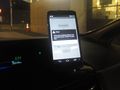
Google maps, blue for parked car, red for destination
Droid error


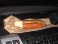
Delicious!
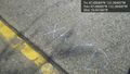
Made it! @47.6868,-122.3840


