Difference between revisions of "2014-03-15 44 -123"
imported>Frogman (→Plans) |
imported>FippeBot m (Location) |
||
| (3 intermediate revisions by one other user not shown) | |||
| Line 28: | Line 28: | ||
== Expedition == | == Expedition == | ||
| − | + | After leaving county-maintained roads, our mountain ascent was filled with gravel and bumps. Luckily Greg's truck is fairly hardy, although his shock absorbers were a little squeaky. We saw a number of motorbike riders, as well as signs forbidding motorbike riding. | |
| + | |||
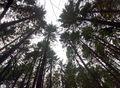
| + | Along the way, we were met with gorgeous views of the valley and vast forests. The hashpoint itself was about 150 meters off of a small dirt road unknown to even the all-knowing Google Maps. We hiked down a relatively steep hill and through short brush to get to the point. There was a mossy tree! | ||
| + | |||
| + | After we got back, I had a birthday party. We ate sushi! | ||
== Tracklog == | == Tracklog == | ||
| Line 38: | Line 42: | ||
--> | --> | ||
<gallery perrow="5"> | <gallery perrow="5"> | ||
| + | Image:2014-03-15 44 -123 valley.jpg | A glimpse into the valley. | ||
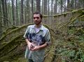
| + | Image:2014-03-15 44 -123 hashpoint.jpg | Greg at the hashpoint! | ||
| + | Image:2014-03-15 44 -123 tree.jpg | This tree was at the hashpoint. | ||
| + | 2014-03-15 44 -123 grins.jpg | Grins! | ||
| + | Image:2014-03-15 44 -123 behind the scenes.jpg | Behind the scenes of the grins picture, taken with Greg's Google Glass. | ||
| + | Image:2014-03-15 44 -123 frogman.jpg | ||
| + | Image:2014-03-15 44 -123 sky.jpg | ||
</gallery> | </gallery> | ||
| Line 43: | Line 54: | ||
{{#vardefine:ribbonwidth|800px}} | {{#vardefine:ribbonwidth|800px}} | ||
<!-- Add any achievement ribbons you earned below, or remove this section --> | <!-- Add any achievement ribbons you earned below, or remove this section --> | ||
| − | + | {{Birthday geohash | |
| − | + | | latitude = 44 | |
| − | + | | longitude = -123 | |
| − | + | | date = 2014-03-15 | |
| − | + | | pronoun = his | |
| − | + | | name = Frogman | |
| − | + | | number = 19th | |
| − | + | }} | |
| − | |||
| − | |||
| − | |||
| − | |||
| − | |||
| − | |||
[[Category:Expeditions]] | [[Category:Expeditions]] | ||
| − | |||
[[Category:Expeditions with photos]] | [[Category:Expeditions with photos]] | ||
| − | |||
| − | |||
| − | |||
| − | |||
| − | |||
[[Category:Coordinates reached]] | [[Category:Coordinates reached]] | ||
| − | + | {{location|US|OR|BE}} | |
| − | |||
| − | |||
| − | |||
| − | |||
| − | |||
| − | |||
| − | |||
| − | |||
| − | |||
| − | |||
| − | |||
| − | |||
| − | |||
| − | |||
| − | |||
| − | |||
| − | |||
Latest revision as of 05:53, 14 August 2019
| Sat 15 Mar 2014 in 44,-123: 44.4083609, -123.4902828 geohashing.info google osm bing/os kml crox |
Location
In the mountains south of Philomath, Oregon.
Participants
- Greg
- Frogman
Plans
It's Frogman's birthday, time for a geohashing trip!
Expedition
After leaving county-maintained roads, our mountain ascent was filled with gravel and bumps. Luckily Greg's truck is fairly hardy, although his shock absorbers were a little squeaky. We saw a number of motorbike riders, as well as signs forbidding motorbike riding.
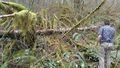
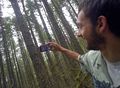
Along the way, we were met with gorgeous views of the valley and vast forests. The hashpoint itself was about 150 meters off of a small dirt road unknown to even the all-knowing Google Maps. We hiked down a relatively steep hill and through short brush to get to the point. There was a mossy tree!
After we got back, I had a birthday party. We ate sushi!
Tracklog
Photos
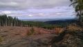
A glimpse into the valley.
Greg at the hashpoint!
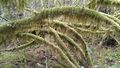
This tree was at the hashpoint.

Grins!
Behind the scenes of the grins picture, taken with Greg's Google Glass.


Achievements
Frogman earned the Birthday Geohash Achievement
|