Difference between revisions of "2014-03-19 50 -113"
From Geohashing
imported>Palmpje m (Cleaned up the ribbon and result codes) |
imported>Jiml m (Add ribbon) |
||
| Line 15: | Line 15: | ||
}} | }} | ||
| − | + | ||
__NOTOC__ | __NOTOC__ | ||
== Location == | == Location == | ||
| − | + | ||
East of Okotoks, AB | East of Okotoks, AB | ||
| + | |||
In the middle of the southbound lane of Highway 2 | In the middle of the southbound lane of Highway 2 | ||
== Participants == | == Participants == | ||
| − | + | ||
| − | |||
* [[User:Guzzby|Guzzby]] | * [[User:Guzzby|Guzzby]] | ||
== Plans == | == Plans == | ||
| − | + | ||
Plan to drive over this location at 100 Km/Hour. The current posted speed limit. Will be going out there around 2:00 pm today. | Plan to drive over this location at 100 Km/Hour. The current posted speed limit. Will be going out there around 2:00 pm today. | ||
== Expedition == | == Expedition == | ||
| − | + | ||
Left the house at 2:00. Reached ground zero around 2:30. | Left the house at 2:00. Reached ground zero around 2:30. | ||
| + | |||
Picked up four geocaches while in the area. | Picked up four geocaches while in the area. | ||
== Photos == | == Photos == | ||
| − | + | ||
| − | |||
| − | |||
<gallery perrow="5"> | <gallery perrow="5"> | ||
Image:2014-03-19 50 -113 guzzby.jpg | Ground Zero | Image:2014-03-19 50 -113 guzzby.jpg | Ground Zero | ||
| Line 47: | Line 46: | ||
== Achievements == | == Achievements == | ||
{{#vardefine:ribbonwidth|800px}} | {{#vardefine:ribbonwidth|800px}} | ||
| − | + | ||
| + | {{Land geohash | ||
| + | | latitude = 50 | ||
| + | | longitude = -113 | ||
| + | | date = 2014-03-19 | ||
| + | | name = [[User:Guzzby|Guzzby]] | ||
| + | }} | ||
{{Speed racer | {{Speed racer | ||
| − | |||
| latitude = 50 | | latitude = 50 | ||
| longitude = -113 | | longitude = -113 | ||
| date = 2014-03-19 | | date = 2014-03-19 | ||
| − | | name = | + | | name = [[User:Guzzby|Guzzby]] |
| speed = 110 km/hour | | speed = 110 km/hour | ||
| + | }} | ||
| − | |||
| − | |||
[[Category:Expeditions]] | [[Category:Expeditions]] | ||
[[Category:Expeditions with photos]] | [[Category:Expeditions with photos]] | ||
[[Category:Coordinates reached]] | [[Category:Coordinates reached]] | ||
Revision as of 21:49, 21 March 2014
| Wed 19 Mar 2014 in 50,-113: 50.7301161, -113.8867846 geohashing.info google osm bing/os kml crox |
Location
East of Okotoks, AB
In the middle of the southbound lane of Highway 2
Participants
Plans
Plan to drive over this location at 100 Km/Hour. The current posted speed limit. Will be going out there around 2:00 pm today.
Expedition
Left the house at 2:00. Reached ground zero around 2:30.
Picked up four geocaches while in the area.
Photos
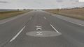
Ground Zero
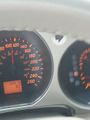
Speedometer


Achievements
Guzzby earned the Land geohash achievement
|

Guzzby earned the Speed racer achievement
by passing through the (50, -113) geohash on 2014-03-19 at 110 km/hour.