Difference between revisions of "2014-03-20 45 -122"
From Geohashing
imported>Michael5000 m |
imported>Michael5000 |
||
| Line 1: | Line 1: | ||
| − | |||
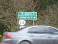
| − | [[ | + | [[File:2014-03-20 45 -122.JPG|thumb|500px|caption:"This car is passing over the hashpoint at ~60 miles per hour."]] |
| − | |||
| − | |||
| − | |||
| − | |||
{{meetup graticule | {{meetup graticule | ||
| lat=45 | | lat=45 | ||
| Line 33: | Line 28: | ||
== Photos == | == Photos == | ||
| − | |||
| − | |||
| − | |||
<gallery perrow="5"> | <gallery perrow="5"> | ||
| + | File:2014-03-20 45 -122.JPG|It is 16 miles from Oregon City to Mollala on Highway 213. | ||
</gallery> | </gallery> | ||
Revision as of 03:27, 21 March 2014

| Thu 20 Mar 2014 in 45,-122: 45.3093655, -122.5686626 geohashing.info google osm bing/os kml crox |
Location
At the intersection of Highway 213 and Henrici Road, southeast of Oregon City.
Participants
Plans
Expedition
I drove down at lunch and parked in the driveway of a nearby church. It's a very busy location without much of interest, so I took my picture and left.
Photos
It is 16 miles from Oregon City to Mollala on Highway 213.