Difference between revisions of "2014-03-29 -43 172"
imported>Quaternary |
imported>FippeBot m (Location) |
||
| (4 intermediate revisions by 2 users not shown) | |||
| Line 1: | Line 1: | ||
| − | [[Image:{{{image|2014_03_29_- | + | [[Image:{{{image|2014_03_29_-43_172_02_On_the_sand_dune_looking_North.JPG }}}|thumb|left]] |
<!-- | <!-- | ||
| Line 37: | Line 37: | ||
<gallery> | <gallery> | ||
| − | Image:2014_03_29_-43_172_Geolocation. | + | Image:2014_03_29_-43_172_Geolocation.png | Arrived! |
</gallery> | </gallery> | ||
| Line 51: | Line 51: | ||
Image:2014_03_29_-43_172_07_Our_marker.jpg | Our marker on the hash site | Image:2014_03_29_-43_172_07_Our_marker.jpg | Our marker on the hash site | ||
Image:2014_03_29_-43_172_08_View_from_the_marker.jpg | The adventurers, photographed from the hash site | Image:2014_03_29_-43_172_08_View_from_the_marker.jpg | The adventurers, photographed from the hash site | ||
| − | Image:2014_03_29_-43_172_09_Escaping_the_waves.jpg| Escaping the Pacific Ocean (last time this geohasher got wet to his | + | Image:2014_03_29_-43_172_09_Escaping_the_waves.jpg| Escaping the Pacific Ocean (last time this geohasher got wet to his waist) |
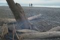
Image:2014_03_29_-43_172_10_Remenants_of_a_fire.jpg| We found a fire that was perhaps lit last night? | Image:2014_03_29_-43_172_10_Remenants_of_a_fire.jpg| We found a fire that was perhaps lit last night? | ||
Image:2014_03_29_-43_172_11_Saying_farewell_to_the_marker.JPG | A final goodbye to the hash point | Image:2014_03_29_-43_172_11_Saying_farewell_to_the_marker.JPG | A final goodbye to the hash point | ||
| Line 59: | Line 59: | ||
== Achievements == | == Achievements == | ||
| + | {{Land geohash | ||
| + | | latitude = -43 | ||
| + | | longitude = 172 | ||
| + | | date = 2014-03-29 | ||
| + | | name = Quaternary | ||
| + | }} | ||
{{drag-along | {{drag-along | ||
| latitude = -43 | | latitude = -43 | ||
| Line 71: | Line 77: | ||
[[Category:Expeditions with photos]] | [[Category:Expeditions with photos]] | ||
[[Category:Coordinates reached]] | [[Category:Coordinates reached]] | ||
| + | {{location|NZ|CAN}} | ||
Latest revision as of 06:01, 14 August 2019

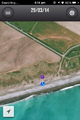
| Sat 29 Mar 2014 in -43,172: -43.8630715, 172.3375972 geohashing.info google osm bing/os kml crox |
Location
Taumutu, Selwyn District, Canterbury, New Zealand
Participants
The Quaternary (talk) family geohashers
Plans
A nice easy beach geohash, and on a Saturday to boot!
Expedition
The nearest settlement to the hash is Taumutu, which means the end of a ridge, or a high ridge. At Taumutu is also found the Ngāti Moki marae.
Luckily the tide wasn't completely in, as this location might well have been underwater!
Tracklog
Arrived!

Photos
Approaching the geohash - at the top of the sand dunes
On the sand dunes looking North
On the sand dunes looking South

Karate Kid 1

Karate Kid 2

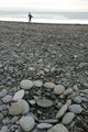
It's around here somewhere
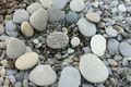
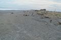
Our marker on the hash site
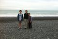
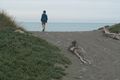
The adventurers, photographed from the hash site
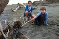
Escaping the Pacific Ocean (last time this geohasher got wet to his waist)
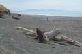
We found a fire that was perhaps lit last night?
A final goodbye to the hash point
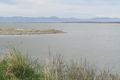
About three kilometres East is Lake Ellesmere / Te Waihora, which is actually a broad, shallow lagoon


Achievements
Quaternary earned the Land geohash achievement
|
Quaternary earned the Drag-along achievement
|