Difference between revisions of "2014-03-29 48 8"
imported>DODO (→Location) |
|||
| (17 intermediate revisions by 5 users not shown) | |||
| Line 15: | Line 15: | ||
}} | }} | ||
| − | + | [[2014-03-25_49_8|previous]] [[2014-03-31 49 8|next]] | |
| + | |||
__NOTOC__ | __NOTOC__ | ||
== Location == | == Location == | ||
| − | + | ||
On a path near Waldprechtsweier | On a path near Waldprechtsweier | ||
== Participants == | == Participants == | ||
| − | + | ||
| − | + | * [[User:DODO|DODO]] | |
== Plans == | == Plans == | ||
| − | + | ||
| + | To start now (13:30) from home on bull and try to be there at 4pm. Coming home by train from Ettlingen or Karlsruhe. | ||
== Expedition == | == Expedition == | ||
| − | + | OK, weather is great, it's Saturday afternoon and I don't have to go rowing (although I planned to), because daylight-saving time starts this weekend and so I can do so in the evening during the week. | |
| + | |||
| + | There are two possible hashpoints, one (48,8) with a 70 KM ride, the other (49,8) with a 80 KM ride (but a closer trainstation). Its already half past one and obviously to late to reach any of them by bike, but the [http://www.greenmover.de/product/e45-herren/ bull] is well fed and I want to try how far the battery will last. | ||
| + | I decided to go southwards, what came out as a good decision, as the wind came from the north. | ||
| + | |||
| + | Shortly after I crossed the river Rhine I saw some storks that welcomed me with a adequate chatter. Then I had to leave the Rhine and ride through prosper landscape and villages, most of the time on well maintained cycle tracks. After a while I came along a forest which was completely covered with bear's garlic. Of course I couldn't resist and made rich pickings. | ||
| + | |||
| + | After that I crossed Karlsruhe-Durlach with its old houses and towers and headed on to Ettlingen with its big castle. It was already quarter to four and so I had to hurry to reach the hash (half way) in time. And so I did. Supported by the wind and the bull I reached maximum speed over 48 KM/h. But at four o'clock I had just reached Malsch. Now there was just a little (but - towars the end - very steep) hill to the hash. Ten minutes later I reached some stairs, but the hash was just 100 m away, and so I decided to stake the bull and walk the rest of the way. The hash itself was rather boring, a way crossing between some wood, a house with a garden and a sports ground. Since little DODO died (as I must confess to myself) on [[2014-03-16_49_8|2014-03-16]] I just left a mark on the ground and left (and even forgot to take a picture of myself). Well, grief... | ||
| + | |||
| + | The hill after the long ride afflicted the bull and he says, he could just support me for the next 15 KM, but downhilling lightened up his mind a little. Nevertheless, the way back to Ettlingen leads against the wind now, and we both had to fight. So we allowed ourselves a pause and some food (at least for me), before we tackled the last 7 Kilometers to Karlsruhe main station. | ||
| + | |||
| + | Lucky enough, 15 minutes later a train to Speyer took us home (the bull still could go 10 KM). And even more lucky, some football supporter (1. FC Kaiserslautern played 2:2 against Karlsruhe) shared the cabin with me and offered me some beer. | ||
== Tracklog == | == Tracklog == | ||
| − | + | [http://www.gpsies.com/map.do?fileId=czeioomfmhqkdaff bull: 94 KM + train: 51 KM] | |
== Photos == | == Photos == | ||
| − | + | ||
| − | |||
| − | |||
<gallery perrow="5"> | <gallery perrow="5"> | ||
| + | Image:2014-03-29_48_8-1.jpg | Some fighting birds | ||
| + | Image:2014-03-29_48_8-3.jpg | Forest covered in bear's garlic | ||
| + | Image:2014-03-29_48_8-2.jpg | pickings | ||
| + | Image:2014-03-29_48_8-4.jpg | Karlsruhe-Durlach | ||
| + | Image:2014-03-29_48_8-5.jpg | Ettlingen | ||
| + | Image:2014-03-29_48_8-12.jpg | I left a marker | ||
| + | Image:2014-03-29_48_8-6.jpg | View to the north... | ||
| + | Image:2014-03-29_48_8-7.jpg | ...east... | ||
| + | Image:2014-03-29_48_8-8.jpg | ...south... | ||
| + | Image:2014-03-29_48_8-9.jpg | ...and west from the hash | ||
| + | Image:2014-03-29_48_8-10.jpg | Back in Ettlingen again | ||
| + | Image:2014-03-29_48_8-11.jpg | an even better view of Ettlingen | ||
</gallery> | </gallery> | ||
== Achievements == | == Achievements == | ||
{{#vardefine:ribbonwidth|800px}} | {{#vardefine:ribbonwidth|800px}} | ||
| − | |||
| − | |||
| − | + | {{land geohash | |
| − | + | | latitude = 48 | |
| − | + | | longitude = 8 | |
| + | | date = 2014-03-29 | ||
| + | | name = DODO | ||
| + | }} | ||
| − | + | {{xkcd centurion|count=1}} | |
| − | |||
| − | |||
| − | |||
| − | |||
| − | |||
[[Category:Expeditions]] | [[Category:Expeditions]] | ||
| − | |||
[[Category:Expeditions with photos]] | [[Category:Expeditions with photos]] | ||
| − | |||
| − | |||
| − | |||
| − | |||
| − | |||
[[Category:Coordinates reached]] | [[Category:Coordinates reached]] | ||
| − | + | {{location|DE|BW|KA}} | |
| − | |||
| − | |||
| − | |||
| − | |||
| − | |||
| − | |||
| − | |||
| − | |||
| − | |||
| − | |||
| − | |||
| − | |||
| − | |||
| − | |||
| − | |||
| − | |||
| − | |||
Latest revision as of 07:18, 24 April 2020
| Sat 29 Mar 2014 in 48,8: 48.8630715, 8.3375972 geohashing.info google osm bing/os kml crox |
Location
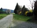
On a path near Waldprechtsweier
Participants
Plans
To start now (13:30) from home on bull and try to be there at 4pm. Coming home by train from Ettlingen or Karlsruhe.
Expedition
OK, weather is great, it's Saturday afternoon and I don't have to go rowing (although I planned to), because daylight-saving time starts this weekend and so I can do so in the evening during the week.
There are two possible hashpoints, one (48,8) with a 70 KM ride, the other (49,8) with a 80 KM ride (but a closer trainstation). Its already half past one and obviously to late to reach any of them by bike, but the bull is well fed and I want to try how far the battery will last. I decided to go southwards, what came out as a good decision, as the wind came from the north.
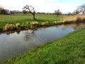
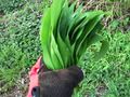
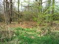
Shortly after I crossed the river Rhine I saw some storks that welcomed me with a adequate chatter. Then I had to leave the Rhine and ride through prosper landscape and villages, most of the time on well maintained cycle tracks. After a while I came along a forest which was completely covered with bear's garlic. Of course I couldn't resist and made rich pickings.
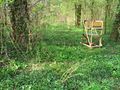
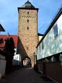
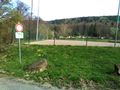
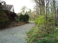
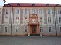
After that I crossed Karlsruhe-Durlach with its old houses and towers and headed on to Ettlingen with its big castle. It was already quarter to four and so I had to hurry to reach the hash (half way) in time. And so I did. Supported by the wind and the bull I reached maximum speed over 48 KM/h. But at four o'clock I had just reached Malsch. Now there was just a little (but - towars the end - very steep) hill to the hash. Ten minutes later I reached some stairs, but the hash was just 100 m away, and so I decided to stake the bull and walk the rest of the way. The hash itself was rather boring, a way crossing between some wood, a house with a garden and a sports ground. Since little DODO died (as I must confess to myself) on 2014-03-16 I just left a mark on the ground and left (and even forgot to take a picture of myself). Well, grief...
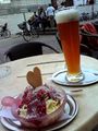
The hill after the long ride afflicted the bull and he says, he could just support me for the next 15 KM, but downhilling lightened up his mind a little. Nevertheless, the way back to Ettlingen leads against the wind now, and we both had to fight. So we allowed ourselves a pause and some food (at least for me), before we tackled the last 7 Kilometers to Karlsruhe main station.
Lucky enough, 15 minutes later a train to Speyer took us home (the bull still could go 10 KM). And even more lucky, some football supporter (1. FC Kaiserslautern played 2:2 against Karlsruhe) shared the cabin with me and offered me some beer.
Tracklog
Photos
Some fighting birds
Forest covered in bear's garlic
pickings
Karlsruhe-Durlach
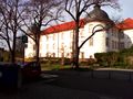
Ettlingen
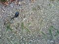
I left a marker
View to the north...
...east...
...south...
...and west from the hash
Back in Ettlingen again
an even better view of Ettlingen


Achievements
DODO earned the Land geohash achievement
|
This user earned the xkcd Nullaturion achievement
|