Difference between revisions of "2014-03-31 49 8"
imported>DODO (→Photos) |
|||
| (4 intermediate revisions by 3 users not shown) | |||
| Line 17: | Line 17: | ||
<!-- edit as necessary --> | <!-- edit as necessary --> | ||
__NOTOC__ | __NOTOC__ | ||
| + | |||
| + | [[2014-03-29_48_8|previous]] [[2014-04-12 48 8|next]] | ||
| + | |||
== Location == | == Location == | ||
<!-- where you've surveyed the hash to be --> | <!-- where you've surveyed the hash to be --> | ||
| Line 29: | Line 32: | ||
== Expedition == | == Expedition == | ||
<!-- how it all turned out. your narrative goes here. --> | <!-- how it all turned out. your narrative goes here. --> | ||
| − | After the great expedition on [[2014-03-29_48_8|saturday]] I realized that todays hash is just 20 KM from home and I could try to repeat the experience. Less time but smaller distance. So I started from work southwards and as I didn't want to cross Speyer on my way, I stayed on the right side of the | + | After the great expedition on [[2014-03-29_48_8|saturday]] I realized that todays hash is just 20 KM from home and I could try to repeat the experience. Less time but smaller distance. So I started from work southwards and as I didn't want to cross Speyer on my way, I stayed on the right side of the Rhine. So I found some swampland that reminds me of the Camargue. Only the Flamingos are missing (but you could hear thousands of other birds). Just some minutes later the pilgrimage church of Waghäusel lies at my way. But I had to proceed southwards and finally reached the bridge of Germersheim where I crossed the river Rhine. Two more villages to cross before I came near the hash. A rapeseed field [[2014-03-25_49_8|again]], but it seemed denser this time and I didn't remark any tracktor tracks from the way. Still 40 m to go. So near and so far. Maybe from the other side. And indeed a single track. 50 m and the right direction. Even the ground is dry and not even muddy. 50m, 40m, 35m but the direction turns to the right. Damn. I came up to 20m but couldn't change the direction. So I accepted the no trespassing and went out of the field again. |
| − | On the other hand, where's one tracktor track, there may be more, lets walk along the field for 20 m. And indeed, another track, another | + | On the other hand, where's one tracktor track, there may be more, lets walk along the field for 20 m. And indeed, another track, another trail and this time the direction is good. 2m distance (OK, it switched on the photo to 3m, but thats still good enough (lower than accuracy). Some quick photos, and a mark outside of the field showing possible followers the right track. Then I hurried back to Germersheim, where a friendly train took me and my bull back home after a 50 KM ride (+16 in the morning from home to work). |
== Tracklog == | == Tracklog == | ||
| Line 56: | Line 59: | ||
== Achievements == | == Achievements == | ||
{{#vardefine:ribbonwidth|800px}} | {{#vardefine:ribbonwidth|800px}} | ||
| − | + | {{land geohash | |
| + | | latitude = 49 | ||
| + | | longitude = 8 | ||
| + | | date = 2014-03-31 | ||
| + | | name = DODO | ||
| + | }} | ||
| − | + | {{Regional geohashing | |
| − | + | | name = [[User:DODO|DODO]] | |
| − | [[ | + | | region = Landkreis Germersheim |
| − | + | | count = 2 | |
| − | + | }} | |
| − | |||
| − | |||
| − | |||
| − | |||
| − | |||
| − | |||
[[Category:Expeditions]] | [[Category:Expeditions]] | ||
| − | |||
[[Category:Expeditions with photos]] | [[Category:Expeditions with photos]] | ||
| − | |||
| − | |||
| − | |||
| − | |||
| − | |||
[[Category:Coordinates reached]] | [[Category:Coordinates reached]] | ||
| − | + | {{location|DE|RP|GER}} | |
| − | |||
| − | |||
| − | |||
| − | |||
| − | |||
| − | |||
| − | |||
| − | |||
| − | |||
| − | |||
| − | |||
| − | |||
| − | |||
| − | |||
| − | |||
| − | |||
| − | |||
Latest revision as of 17:20, 25 April 2020
| Mon 31 Mar 2014 in 49,8: 49.1540688, 8.3096559 geohashing.info google osm bing/os kml crox |
Location
In a field east of Rülzheim.
Participants
Plans
To come along on my way back home (its more vice versa: I'll come along home on my way to the hash)
Expedition
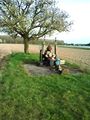
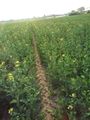
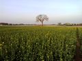
After the great expedition on saturday I realized that todays hash is just 20 KM from home and I could try to repeat the experience. Less time but smaller distance. So I started from work southwards and as I didn't want to cross Speyer on my way, I stayed on the right side of the Rhine. So I found some swampland that reminds me of the Camargue. Only the Flamingos are missing (but you could hear thousands of other birds). Just some minutes later the pilgrimage church of Waghäusel lies at my way. But I had to proceed southwards and finally reached the bridge of Germersheim where I crossed the river Rhine. Two more villages to cross before I came near the hash. A rapeseed field again, but it seemed denser this time and I didn't remark any tracktor tracks from the way. Still 40 m to go. So near and so far. Maybe from the other side. And indeed a single track. 50 m and the right direction. Even the ground is dry and not even muddy. 50m, 40m, 35m but the direction turns to the right. Damn. I came up to 20m but couldn't change the direction. So I accepted the no trespassing and went out of the field again.
On the other hand, where's one tracktor track, there may be more, lets walk along the field for 20 m. And indeed, another track, another trail and this time the direction is good. 2m distance (OK, it switched on the photo to 3m, but thats still good enough (lower than accuracy). Some quick photos, and a mark outside of the field showing possible followers the right track. Then I hurried back to Germersheim, where a friendly train took me and my bull back home after a 50 KM ride (+16 in the morning from home to work).
Tracklog
Photos
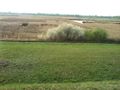
beautiful swampland
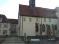
Waghäusel
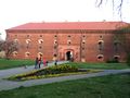
Germersheim
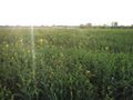
view to the hash. Rapeseed again
a riddle near the hash
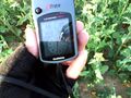
not close enough
another lane, another chance
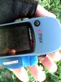
good enough

happy hasher
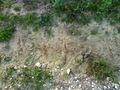
view from the hash
marker


Achievements
DODO earned the Land geohash achievement
|
DODO earned the Regional geohashing achievement
|