Difference between revisions of "2014-04-08 47 -122"
imported>Thomcat ([live] Hooray!) |
imported>FippeBot m (Location) |
||
| (4 intermediate revisions by one other user not shown) | |||
| Line 1: | Line 1: | ||
| + | [[File:2014-04-08_47_-122_CreekPanorama.jpg|left|900px]] | ||
{{meetup graticule | {{meetup graticule | ||
| lat=47 | | lat=47 | ||
| Line 6: | Line 7: | ||
| graticule_link=Seattle, Washington | | graticule_link=Seattle, Washington | ||
}} | }} | ||
| − | + | <br style="clear:left;"> | |
__NOTOC__ | __NOTOC__ | ||
== Location == | == Location == | ||
| Line 18: | Line 19: | ||
== Expedition == | == Expedition == | ||
| − | + | I needed to drive to my bank in Bellevue to cash in some coins (No fee that way). The most interesting piece of that transaction was a 20 euro cent coin. Whoops! At the bank, the skies (cloudy all day) were threatening rain. | |
| + | |||
| + | From there I proceeded down the eastern side of Lake Sammamish to the park in question. Sitting at the southern end of the lake, this park sits very close to a freeway entrance and my route home. Was it on the way? Not strictly... but it wasn't too bad. On the way, the rain started coming down heavily. A wet wilderness geohash was in store for me. | ||
| + | |||
| + | I parked at the soccer parking lot south of the hash point. Why are they called the Costco soccer fields? Not because they come in a bundle-pack of 12, but because the building across the street was... Costco. No need to go in today, thanks. | ||
| + | |||
| + | The path was barred with a "no vehicles" gate but otherwise completely accessible. The trail looked good, at least to start. I brought an umbrella, because if I am going to get "drowned rat" living in Seattle, I am going to have to '''earn''' it. Around a corner, the trail was washed out. That's a polite way to say there was a puddle some 20 feet across. Not a new body of water, I followed in footprints in the mud along one side. Other washouts were tracked with footprints, dogprints and bicycles. | ||
| + | |||
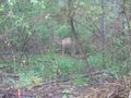
| + | Now fairly close to the point, I looked up to see not one but two deer. I sidled left a bit for a better shot and they left - though I saw one of them again on the way out. | ||
| + | |||
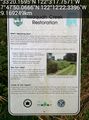
| + | Just south of the hashpoint on the satellite photo was a clump of trees or bushes. Those bushes also hosted a sign describing the Issaquah Creek restoration project. A worthy effort, though the sign was not terribly clean. I took advantage of the grime (and/or mold) to leave a message to future geohashers and their deer. | ||
| + | Just around the corner, I reached the point itself. While uploading my message I went from 2.2 meters away out to about 9 meters, alas. Rain, wet foliage, and my umbrella were likely candidates. Just a few feet from the hashpoint was the creek itself, making a nice elbow bend. Water was running strong - runoff more than rain in this case. | ||
*Hooray! -- [[User:Thomcat|Thomcat]] ([[User talk:Thomcat|talk]]) [http://www.openstreetmap.org/?lat=47.55551509&lon=-122.05490717&zoom=16&layers=B000FTF @47.5555,-122.0549] 16:01, 8 April 2014 (PDT) | *Hooray! -- [[User:Thomcat|Thomcat]] ([[User talk:Thomcat|talk]]) [http://www.openstreetmap.org/?lat=47.55551509&lon=-122.05490717&zoom=16&layers=B000FTF @47.5555,-122.0549] 16:01, 8 April 2014 (PDT) | ||
| − | + | ||
| − | + | As I returned I snapped a few more pictures of the sign and spotted the deer again (or perhaps it was yet another deer - dunno). I snapped his picture next to mine - not sure if he followed my exhortation to provide a stupid grin. I failed to fall on my keister in the mud and ended up back at the car. | |
| + | |||
| + | Though damp, this was a beautiful geohashing experience! | ||
== Photos == | == Photos == | ||
| − | |||
| − | |||
| − | |||
<gallery perrow="5"> | <gallery perrow="5"> | ||
| + | Image:2014-04-08_47_-122_RainCar.jpg | ||
| + | Image:2014-04-08_47_-122_Trail.jpg | ||
| + | Image:2014-04-08_47_-122_Washout.jpg | ||
| + | Image:2014-04-08_47_-122_Bicycles.jpg | ||
| + | Image:2014-04-08_47_-122_Wildlife.jpg | ||
| + | Image:2014-04-08_47_-122_Wildlife2.jpg | ||
| + | Image:2014-04-08_47_-122_TrailMarker.jpg | ||
| + | Image:2014-04-08_47_-122_GeohashPoint.jpg | ||
| + | Image:2014-04-08_47_-122_DryGeohasher.jpg | ||
| + | Image:2014-04-08_47_-122_GeohasherAndDeer.jpg | ||
| + | Image:2014-04-08_47_-122_Wildlife3.jpg | ||
| + | |||
| + | Image:2014-04-08_47_-122_thomcat_1396998002123.jpg | Testing Kit Kat upload capabilities [http://www.openstreetmap.org/?lat=47.79724071&lon=-122.20620545&zoom=16&layers=B000FTF @47.7972,-122.2062] | ||
</gallery> | </gallery> | ||
| − | |||
| − | |||
| − | |||
| − | |||
| − | |||
| − | |||
| − | |||
| − | |||
[[Category:Expeditions]] | [[Category:Expeditions]] | ||
| − | |||
[[Category:Expeditions with photos]] | [[Category:Expeditions with photos]] | ||
| − | |||
| − | |||
| − | |||
| − | |||
| − | |||
[[Category:Coordinates reached]] | [[Category:Coordinates reached]] | ||
| − | + | {{location|US|WA|KN}} | |
| − | |||
| − | |||
| − | |||
| − | |||
| − | |||
| − | |||
| − | |||
| − | |||
| − | |||
| − | |||
| − | |||
| − | |||
| − | |||
| − | |||
| − | |||
| − | |||
| − | |||
Latest revision as of 06:07, 14 August 2019

| Tue 8 Apr 2014 in Seattle: 47.5555999, -122.0549325 geohashing.info google osm bing/os kml crox |
Location
Between a trail and a stream in Lake Sammamish State Park.
Participants
Plans
Stop by after work, then brave opening day Seattle Mariner Traffic to get home.
Expedition
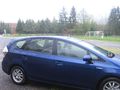
I needed to drive to my bank in Bellevue to cash in some coins (No fee that way). The most interesting piece of that transaction was a 20 euro cent coin. Whoops! At the bank, the skies (cloudy all day) were threatening rain.
From there I proceeded down the eastern side of Lake Sammamish to the park in question. Sitting at the southern end of the lake, this park sits very close to a freeway entrance and my route home. Was it on the way? Not strictly... but it wasn't too bad. On the way, the rain started coming down heavily. A wet wilderness geohash was in store for me.
I parked at the soccer parking lot south of the hash point. Why are they called the Costco soccer fields? Not because they come in a bundle-pack of 12, but because the building across the street was... Costco. No need to go in today, thanks.
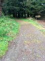
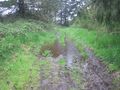
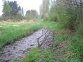
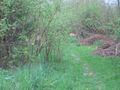
The path was barred with a "no vehicles" gate but otherwise completely accessible. The trail looked good, at least to start. I brought an umbrella, because if I am going to get "drowned rat" living in Seattle, I am going to have to earn it. Around a corner, the trail was washed out. That's a polite way to say there was a puddle some 20 feet across. Not a new body of water, I followed in footprints in the mud along one side. Other washouts were tracked with footprints, dogprints and bicycles.
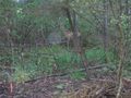
Now fairly close to the point, I looked up to see not one but two deer. I sidled left a bit for a better shot and they left - though I saw one of them again on the way out.
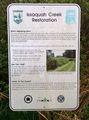
Just south of the hashpoint on the satellite photo was a clump of trees or bushes. Those bushes also hosted a sign describing the Issaquah Creek restoration project. A worthy effort, though the sign was not terribly clean. I took advantage of the grime (and/or mold) to leave a message to future geohashers and their deer.
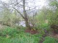
Just around the corner, I reached the point itself. While uploading my message I went from 2.2 meters away out to about 9 meters, alas. Rain, wet foliage, and my umbrella were likely candidates. Just a few feet from the hashpoint was the creek itself, making a nice elbow bend. Water was running strong - runoff more than rain in this case.
- Hooray! -- Thomcat (talk) @47.5555,-122.0549 16:01, 8 April 2014 (PDT)
As I returned I snapped a few more pictures of the sign and spotted the deer again (or perhaps it was yet another deer - dunno). I snapped his picture next to mine - not sure if he followed my exhortation to provide a stupid grin. I failed to fall on my keister in the mud and ended up back at the car.
Though damp, this was a beautiful geohashing experience!
Photos


Testing Kit Kat upload capabilities @47.7972,-122.2062


