Difference between revisions of "2014-04-17 51 -114"
From Geohashing
imported>Guzzby (→Photos) |
m (More specific location) |
||
| (5 intermediate revisions by 4 users not shown) | |||
| Line 15: | Line 15: | ||
}} | }} | ||
| − | + | ||
__NOTOC__ | __NOTOC__ | ||
== Location == | == Location == | ||
| − | |||
1 Km Southwest of the Glencoe Golf and Country Club in Calgary, AB. | 1 Km Southwest of the Glencoe Golf and Country Club in Calgary, AB. | ||
| Line 24: | Line 23: | ||
== Participants == | == Participants == | ||
| − | + | ||
| − | |||
* [[User:Guzzby|Guzzby]] | * [[User:Guzzby|Guzzby]] | ||
== Plans == | == Plans == | ||
| − | + | ||
Plan on driving out to the hash site around 1:30pm. Take some pictures. There is one geocache nearby that I will try to find. Then I am going to search for 2 other geocaches in the area nearby, that I wasn't able to find last summer. | Plan on driving out to the hash site around 1:30pm. Take some pictures. There is one geocache nearby that I will try to find. Then I am going to search for 2 other geocaches in the area nearby, that I wasn't able to find last summer. | ||
== Expedition == | == Expedition == | ||
| − | + | ||
| − | Left at 1:30pm. Arrived around 2:00pm. | + | Left at 1:30pm. Arrived around 2:00pm. Was actually able to stand on ground zero and take some pictures!. Couldn't get near the first geocache, too many people. Found the second geocache. Searched for 30 minutes for the third geocache, but couldn't find it. I think it's gone. |
== Photos == | == Photos == | ||
| − | + | ||
| − | |||
| − | |||
<gallery perrow="5"> | <gallery perrow="5"> | ||
Image:2014-04-17_51_-114_guzzby1.jpg | View to the north | Image:2014-04-17_51_-114_guzzby1.jpg | View to the north | ||
| Line 50: | Line 46: | ||
== Achievements == | == Achievements == | ||
{{#vardefine:ribbonwidth|800px}} | {{#vardefine:ribbonwidth|800px}} | ||
| − | + | {{#vardefine:ribbonwidth|800px}} | |
| + | {{Land geohash | latitude = 51 | longitude = -114 | date = 2014-04-17 | name = [[User:Guzzby|Guzzby]] }} | ||
| − | |||
| − | |||
| − | |||
| − | |||
| − | + | [[Category:Expeditions]] | |
| − | |||
| − | [[Category: | ||
| − | |||
| − | |||
| − | |||
| − | |||
[[Category:Expeditions with photos]] | [[Category:Expeditions with photos]] | ||
| − | |||
| − | |||
| − | |||
| − | |||
| − | |||
[[Category:Coordinates reached]] | [[Category:Coordinates reached]] | ||
| − | + | {{location|CA|AB|RV}} | |
| − | |||
| − | |||
| − | |||
| − | |||
| − | |||
| − | |||
| − | |||
| − | |||
| − | |||
| − | |||
| − | |||
| − | |||
| − | |||
| − | |||
| − | |||
| − | |||
| − | |||
Latest revision as of 00:06, 10 August 2020
| Thu 17 Apr 2014 in 51,-114: 51.0205271, -114.3270998 geohashing.info google osm bing/os kml crox |
Location
1 Km Southwest of the Glencoe Golf and Country Club in Calgary, AB. Near Hwy 8 and on Range Road 32
Participants
Plans
Plan on driving out to the hash site around 1:30pm. Take some pictures. There is one geocache nearby that I will try to find. Then I am going to search for 2 other geocaches in the area nearby, that I wasn't able to find last summer.
Expedition
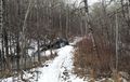
Left at 1:30pm. Arrived around 2:00pm. Was actually able to stand on ground zero and take some pictures!. Couldn't get near the first geocache, too many people. Found the second geocache. Searched for 30 minutes for the third geocache, but couldn't find it. I think it's gone.
Photos
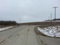
View to the north
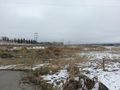
View to the east
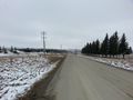
View to the south
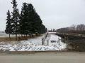
View to the west
Approaching third cache site


Achievements
Guzzby earned the Land geohash achievement
|