Difference between revisions of "2014-04-18 52 5"
From Geohashing
imported>JwB (Created page with "{{subst:Expedition |lat = 52 |lon = 5 |date = 2014-04-18 }}") |
(Source: User:Tchakkazulu) |
||
| (3 intermediate revisions by 2 users not shown) | |||
| Line 18: | Line 18: | ||
__NOTOC__ | __NOTOC__ | ||
== Location == | == Location == | ||
| − | + | on the curb of a residential area in Laren | |
== Participants == | == Participants == | ||
| − | + | *[[User:JwB|JwB]] ([[User talk:JwB|talk]]) | |
| − | + | *[[User:Tchakkazulu|Tchakkazulu]] | |
| − | |||
== Plans == | == Plans == | ||
| − | + | ===JwB=== | |
| + | break the commute, deviate ~ 1 km each way | ||
== Expedition == | == Expedition == | ||
| − | + | ===JwB=== | |
| + | drive in, | ||
| − | == | + | hit, |
| − | + | ||
| + | and run | ||
| + | |||
| + | ===Tchakkazulu=== | ||
| + | Got within my GPSr's accuracy, but only *just*. Still counts! | ||
== Photos == | == Photos == | ||
| − | + | ===JwB=== | |
| − | |||
| − | |||
<gallery perrow="5"> | <gallery perrow="5"> | ||
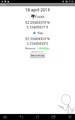
| + | Image:2014-04-18 52 5 proof.png | just there | ||
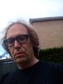
| + | Image:2014-04-18 52 5 grin.jpg | max grin, minimal surroundings | ||
</gallery> | </gallery> | ||
| Line 45: | Line 50: | ||
| − | |||
| − | |||
| − | |||
| − | |||
| − | |||
| − | |||
| − | |||
| − | |||
| − | |||
| − | |||
| − | |||
[[Category:Expeditions]] | [[Category:Expeditions]] | ||
| − | |||
[[Category:Expeditions with photos]] | [[Category:Expeditions with photos]] | ||
| − | + | ||
| − | |||
| − | |||
| − | |||
| − | |||
[[Category:Coordinates reached]] | [[Category:Coordinates reached]] | ||
| − | + | {{location|NL|NH}} | |
| − | |||
| − | |||
| − | |||
| − | |||
| − | |||
| − | |||
| − | |||
| − | |||
| − | |||
| − | |||
| − | |||
| − | |||
| − | |||
| − | |||
| − | |||
| − | |||
| − | |||
Latest revision as of 15:38, 31 March 2020
| Fri 18 Apr 2014 in 52,5: 52.2560337, 5.2340552 geohashing.info google osm bing/os kml crox |
Location
on the curb of a residential area in Laren
Participants
Plans
JwB
break the commute, deviate ~ 1 km each way
Expedition
JwB
drive in,
hit,
and run
Tchakkazulu
Got within my GPSr's accuracy, but only *just*. Still counts!
Photos
JwB
just there
max grin, minimal surroundings

