Difference between revisions of "2014-04-22 52 5"
From Geohashing
imported>JwB m |
imported>JwB m |
||
| Line 24: | Line 24: | ||
see if I can stop close enough on my way to work | see if I can stop close enough on my way to work | ||
== Expedition == | == Expedition == | ||
| − | + | Parking place nearby. Road is busy in rush hour, so wait a little for a safe crossing. Then walk back an effortless 50 meters and collect the proof. | |
| − | |||
| − | |||
| − | |||
== Photos == | == Photos == | ||
| − | |||
| − | |||
| − | |||
<gallery perrow="5"> | <gallery perrow="5"> | ||
| + | Image:2014-04-22 52 5 ditch.jpg | there it is, in the ditch | ||
| + | Image:2014-04-22 52 5 proof.png | tadadaa | ||
| + | Image:2014-04-22 52 5 road.jpg | a bit of my hair | ||
</gallery> | </gallery> | ||
== Achievements == | == Achievements == | ||
{{#vardefine:ribbonwidth|800px}} | {{#vardefine:ribbonwidth|800px}} | ||
| − | + | {{Easy_geohash | |
| + | | latitude = 52 | ||
| + | | longitude = 5 | ||
| + | | date = date 2014-04-22 | ||
| + | | name = JwB | ||
| + | }} | ||
<!-- =============== USEFUL CATEGORIES FOLLOW ================ | <!-- =============== USEFUL CATEGORIES FOLLOW ================ | ||
| − | |||
| − | |||
| − | |||
| − | |||
| − | |||
| − | |||
| − | |||
| − | |||
| − | |||
| − | |||
[[Category:Expeditions]] | [[Category:Expeditions]] | ||
| − | |||
[[Category:Expeditions with photos]] | [[Category:Expeditions with photos]] | ||
| − | |||
| − | |||
| − | |||
| − | |||
| − | |||
[[Category:Coordinates reached]] | [[Category:Coordinates reached]] | ||
| − | |||
| − | |||
| − | |||
| − | |||
| − | |||
| − | |||
| − | |||
| − | |||
| − | |||
| − | |||
| − | |||
| − | |||
| − | |||
| − | |||
| − | |||
| − | |||
| − | |||
| − | |||
Revision as of 09:08, 22 April 2014
| Tue 22 Apr 2014 in 52,5: 52.3287890, 5.4647718 geohashing.info google osm bing/os kml crox |
Location
alongside the gooiseweg, they're building a new road there
Participants
Plans
see if I can stop close enough on my way to work
Expedition
Parking place nearby. Road is busy in rush hour, so wait a little for a safe crossing. Then walk back an effortless 50 meters and collect the proof.
Photos
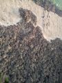
there it is, in the ditch
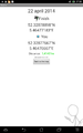
tadadaa
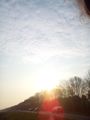
a bit of my hair


Achievements
JwB has visited an Easy Geohash
|