Difference between revisions of "2014-04-25 41 -86"
From Geohashing
imported>Buttercup (Created page with "{{meetup graticule | lat=41 | lon=-86 | date=2014-04-25 }} <!-- edit as necessary --> __NOTOC__ == Location == <!-- where you've surveyed the hash to be --> On a road in Roc...") |
imported>FippeBot m (Location) |
||
| Line 46: | Line 46: | ||
[[Category:Expeditions with photos]] | [[Category:Expeditions with photos]] | ||
[[Category:Coordinates reached]] | [[Category:Coordinates reached]] | ||
| + | {{location|US|IN|FU}} | ||
Latest revision as of 00:13, 7 August 2019
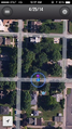
| Fri 25 Apr 2014 in 41,-86: 41.0694246, -86.2170305 geohashing.info google osm bing/os kml crox |
Location
On a road in Rochester, IN
Participants
Plans
I honestly didn't have any plans to get this hash.
Expedition
Here is the story: I was traveling down to Brown County State Park for my bachelorette party and I always look to see about hashes before I take a road trip. This hash was about a 5 minute detour from my typical route so I decided to get it. It wasn't difficult, and I didn't even get out of my car to get it so that was a new one.
Photos
GPS
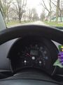
Success!

Achievements

Buttercup earned the Speed racer achievement
by passing through the (41, -86) geohash on 2014-04-25 at 35 MPH.

Buttercup earned the Land geohash achievement
|