Difference between revisions of "2014-04-25 51 -115"
imported>Guzzby (→Location) |
m (More specific location) |
||
| (20 intermediate revisions by 4 users not shown) | |||
| Line 1: | Line 1: | ||
| − | |||
| − | |||
| − | |||
| − | |||
| − | |||
| − | |||
| − | |||
| − | |||
| − | |||
{{meetup graticule | {{meetup graticule | ||
| lat=51 | | lat=51 | ||
| Line 15: | Line 6: | ||
}} | }} | ||
| − | + | ||
__NOTOC__ | __NOTOC__ | ||
== Location == | == Location == | ||
| − | + | ||
| − | 1 | + | 1 Km NE of Grotto Mountain Pond and 2 Km west of Exshaw, Alberta Canada |
== Participants == | == Participants == | ||
| − | + | ||
| − | |||
* [[User:Guzzby|Guzzby]] | * [[User:Guzzby|Guzzby]] | ||
== Plans == | == Plans == | ||
| − | + | ||
| − | When I looked at eupeodes map this morning I saw it was possible to reach ground zero at two different graticules. I planned to leave at 10:00 am and drive to the farthest one first. | + | When I looked at eupeodes map this morning I saw it was possible to reach ground zero at two different graticules. |
| + | I planned to leave at 10:00 am and drive to the farthest one first. | ||
| + | |||
| + | I was going to park at the Grotto Lake parking lot then walk up Grotto Canyon trail. There is a geocache called | ||
| + | "Love Grotto" and the geohash was located 90 meters NE of it. | ||
| + | |||
| + | I was then going to continue another 700 meters up the trail and find 3 more geocaches. Next I was going to drive back to the city and go to the geohash in town. | ||
== Expedition == | == Expedition == | ||
| − | + | ||
| − | I left the house around 10:30 am. I was driving out on highway 1 and I missed the turnoff for Exshaw. I had to drive to Deadman's Flat before I could turn around and head back to Exshaw. When I got to the Grotto Lake parking lot it was around 12:00 noon. I started up the trail which parallels the road for 800 meters where it meets the creek | + | I left the house around 10:30 am. I was driving out on highway 1 and I missed the turnoff for Exshaw. |
| + | I had to drive to Deadman's Flat before I could turn around and head back to Exshaw. | ||
| + | |||
| + | When I got to the Grotto Lake parking lot it was around 12:00 noon. I started up the trail which parallels | ||
| + | the road for 800 meters where it meets the creek. Then the trail continues northward along the creek. | ||
| + | Eventually the trail joined with the creek and the rest of the trail continued up the creek bed. | ||
| + | The flood here last year completely wiped out the trail and left a mess of rocks and trees behind. | ||
| + | I approached the "Love Grotto" geocache and climbed up the side of the mountain to the cliff face and | ||
| + | found it. I moved along the cliff face to the closest point I could get to the geohash, which was | ||
| + | approximately 50 meters. I took a couple of pictures of the cliff and then climbed back down to the | ||
| + | creek and continued up the creek bed. | ||
| + | |||
| + | I found the "Grotto Canyon View" geocache about 300 meters up the | ||
| + | creek bed. From here I continued another 150 meters and searched for the "Grotto Canyon Micro" geocache. | ||
| + | Apparently it looks like the flood has removed the trees the geocache was hiding in. | ||
| + | |||
| + | I continued another 130 meters up the creek bed and then searched the mountainside for the | ||
| + | "Gotto Goto Grotto" geocache. My GPS was spinning all over the place. | ||
| + | I searched for about 20 minutes before giving up. | ||
| + | |||
| + | I then turned around and came back to the parking lot. | ||
| + | Next I headed back to Calgary to find the geohash located in Cougar Ridge. | ||
== Photos == | == Photos == | ||
| − | + | ||
| − | |||
| − | |||
<gallery perrow="5"> | <gallery perrow="5"> | ||
Image:2014-04-25_51_-115_guzzby1.jpg | Start of trail | Image:2014-04-25_51_-115_guzzby1.jpg | Start of trail | ||
| Line 56: | Line 71: | ||
== Achievements == | == Achievements == | ||
{{#vardefine:ribbonwidth|800px}} | {{#vardefine:ribbonwidth|800px}} | ||
| − | |||
| − | |||
| − | |||
| − | |||
| − | |||
| − | + | {{Cliffs of Despair| name = [[User:Guzzby|Guzzby]] | latitude = 51 | longitude = -115 | date = 2014-04-25 | terrain = a cliff face}} | |
| + | {{Hash collision | latitude = 51 | longitude = -115 | date = 2014-04-25 | name = [[User:Guzzby|Guzzby]] | id = GC849 | link = http://www.geocaching.com/geocache/GC849_love-grotto | distance = 90 meters | image = 2014-04-25_51_-115_guzzby5.jpg }} | ||
| + | {{Multihash | latitude1 = 51 | longitude1 = -115 | latitude2 = 51 | longitude2 = -114 | date = 2014-04-25 | name = [[User:Guzzby|Guzzby]] | image = 2014-04-25_51_-114_guzzby6.jpg }} | ||
| + | {{gratuitous ribbon | latitude = 51 | longitude = -115 | date = 2014-04-25 | achievement = Stone Snowman Award | description = finding a stone snowman near the geohash (within 700 meters)| name = [[User:Guzzby|Guzzby]] | image = 2014-04-25 51 -115 guzzbyb.jpg }} | ||
| − | |||
| − | |||
| − | |||
| − | |||
| − | |||
[[Category:Expeditions]] | [[Category:Expeditions]] | ||
| − | |||
[[Category:Expeditions with photos]] | [[Category:Expeditions with photos]] | ||
| − | |||
| − | |||
| − | |||
| − | |||
| − | |||
| − | |||
| − | |||
| − | |||
| − | |||
[[Category:Coordinates not reached]] | [[Category:Coordinates not reached]] | ||
| − | |||
| − | |||
[[Category:Not reached - Mother Nature]] | [[Category:Not reached - Mother Nature]] | ||
| − | + | {{location|CA|AB|BN}} | |
| − | |||
| − | |||
| − | |||
| − | |||
| − | |||
| − | |||
| − | |||
| − | |||
| − | |||
| − | |||
Latest revision as of 00:07, 10 August 2020
| Fri 25 Apr 2014 in 51,-115: 51.0694246, -115.2170305 geohashing.info google osm bing/os kml crox |
Location
1 Km NE of Grotto Mountain Pond and 2 Km west of Exshaw, Alberta Canada
Participants
Plans
When I looked at eupeodes map this morning I saw it was possible to reach ground zero at two different graticules. I planned to leave at 10:00 am and drive to the farthest one first.
I was going to park at the Grotto Lake parking lot then walk up Grotto Canyon trail. There is a geocache called "Love Grotto" and the geohash was located 90 meters NE of it.
I was then going to continue another 700 meters up the trail and find 3 more geocaches. Next I was going to drive back to the city and go to the geohash in town.
Expedition
I left the house around 10:30 am. I was driving out on highway 1 and I missed the turnoff for Exshaw. I had to drive to Deadman's Flat before I could turn around and head back to Exshaw.
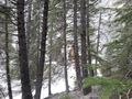
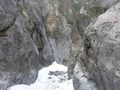
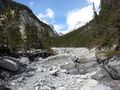
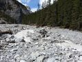
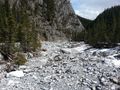
When I got to the Grotto Lake parking lot it was around 12:00 noon. I started up the trail which parallels the road for 800 meters where it meets the creek. Then the trail continues northward along the creek. Eventually the trail joined with the creek and the rest of the trail continued up the creek bed. The flood here last year completely wiped out the trail and left a mess of rocks and trees behind. I approached the "Love Grotto" geocache and climbed up the side of the mountain to the cliff face and found it. I moved along the cliff face to the closest point I could get to the geohash, which was approximately 50 meters. I took a couple of pictures of the cliff and then climbed back down to the creek and continued up the creek bed.
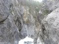
I found the "Grotto Canyon View" geocache about 300 meters up the creek bed. From here I continued another 150 meters and searched for the "Grotto Canyon Micro" geocache. Apparently it looks like the flood has removed the trees the geocache was hiding in.
I continued another 130 meters up the creek bed and then searched the mountainside for the "Gotto Goto Grotto" geocache. My GPS was spinning all over the place. I searched for about 20 minutes before giving up.
I then turned around and came back to the parking lot. Next I headed back to Calgary to find the geohash located in Cougar Ridge.
Photos
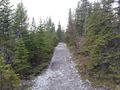
Start of trail
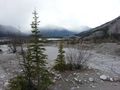
View of creek bed
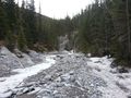
Trail joins creek bed
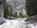
Approaching ground zero
View from "Love Grotto" geocache
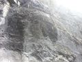
Geohash is 50 meters northeast beyond this cliff face!
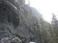
Another view of cliff
Continuing up the trail
Continuing up the trail
Near "Grotto Canyon View" geocache
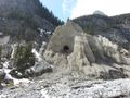
Rock snowman
Is that a bear cave?
As far as I went


Achievements
Guzzby earned the Cliffs of Despair consolation prize
|
Guzzby earned the Hash collision achievement
|
Guzzby earned the Multihash Achievement
|
Guzzby earned the Stone Snowman Award
|