Difference between revisions of "2014-04-27 34 -118"
imported>Bravissimo594 m ([live picture] Marked with information. [http://www.openstreetmap.org/?lat=34.07040000&lon=-118.27300000&zoom=16&layers=B000FTF @34.0704,-118.2730]) |
imported>FippeBot m (Location) |
||
| (5 intermediate revisions by one other user not shown) | |||
| Line 1: | Line 1: | ||
| + | {{Advert | ||
| + | |image=2014-04-27 34 -118 Bravissimo594 1398654318736.jpg}} | ||
<!-- If you did not specify these parameters in the template, please substitute appropriate values for IMAGE, LAT, LON, and DATE (YYYY-MM-DD format) | <!-- If you did not specify these parameters in the template, please substitute appropriate values for IMAGE, LAT, LON, and DATE (YYYY-MM-DD format) | ||
| Line 20: | Line 22: | ||
<!-- where you've surveyed the hash to be --> | <!-- where you've surveyed the hash to be --> | ||
*In front of a residence in Historic Filipinotown. [[Los Angeles, California|Los Angeles]] graticule. | *In front of a residence in Historic Filipinotown. [[Los Angeles, California|Los Angeles]] graticule. | ||
| + | *[http://en.wikipedia.org/wiki/Historic_Filipinotown Historic Filipinotown] on Wikipedia. | ||
== Participants == | == Participants == | ||
| Line 33: | Line 36: | ||
== Expedition == | == Expedition == | ||
<!-- how it all turned out. your narrative goes here. --> | <!-- how it all turned out. your narrative goes here. --> | ||
| + | === [[User:Bravissimo594|Bravissimo594]] ([[User talk:Bravissimo594|talk]]) === | ||
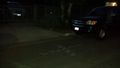
| + | This was about a 20-minute drive from home. The lack of significant traffic along the way on a Sunday evening made the trip smooth. Parking, on the other hand, is a big challenge in this neighborhood. I found a spot about a block away and walked up to the the hash point. After a GPS hash dance, I settled in on the spot, marked it with chalk, headed over to a nearby street light for a photo, snapped a few others, and then headed on my way. Quick and easy ... but without any other geohashers to be found. [[User:Boppy5|Boppy5]] had to get up at 4:00am the next day, so I traveled alone on this one. | ||
== Tracklog == | == Tracklog == | ||
| Line 50: | Line 55: | ||
Image:2014-04-27_34_-118_Bravissimo594_1398654318736.jpg | Marked with information. [http://www.openstreetmap.org/?lat=34.07040000&lon=-118.27300000&zoom=16&layers=B000FTF @34.0704,-118.2730] | Image:2014-04-27_34_-118_Bravissimo594_1398654318736.jpg | Marked with information. [http://www.openstreetmap.org/?lat=34.07040000&lon=-118.27300000&zoom=16&layers=B000FTF @34.0704,-118.2730] | ||
| + | |||
| + | Image:2014-04-27_34_-118_Bravissimo594_1398654154005.jpg | The street. [http://www.openstreetmap.org/?lat=34.07030000&lon=-118.27300000&zoom=16&layers=B000FTF @34.0703,-118.2730] | ||
</gallery> | </gallery> | ||
| Line 63: | Line 70: | ||
<!-- Potential categories. Please include all the ones appropriate to your expedition --> | <!-- Potential categories. Please include all the ones appropriate to your expedition --> | ||
| − | <!-- If this is a planning page: | + | <!-- If this is a planning page: |
| − | [[Category:Expedition planning]] | + | [[Category:Expedition planning]] --> |
| − | <!-- An actual expedition: | + | <!-- An actual expedition: --> |
[[Category:Expeditions]] | [[Category:Expeditions]] | ||
| − | |||
[[Category:Expeditions with photos]] | [[Category:Expeditions with photos]] | ||
| − | [[Category:Expeditions with videos]] | + | <!-- [[Category:Expeditions with videos]] |
[[Category:Expedition without GPS]] | [[Category:Expedition without GPS]] | ||
--> | --> | ||
| − | <!-- if you reached your coords: | + | <!-- if you reached your coords: --> |
[[Category:Coordinates reached]] | [[Category:Coordinates reached]] | ||
| − | + | <!-- or if you failed :( | |
| − | |||
[[Category:Coordinates not reached]] | [[Category:Coordinates not reached]] | ||
-- and a reason -- | -- and a reason -- | ||
| Line 95: | Line 100: | ||
(Don't forget to delete this final close comment marker) --> | (Don't forget to delete this final close comment marker) --> | ||
| + | {{location|US|CA|LO}} | ||
Latest revision as of 06:20, 14 August 2019
| Have you seen our geohashing marker? We'd love to hear from you! Click here to say "hi" and tell us what you've seen!
Curious about what geohashing is? Read more! |  |
| Sun 27 Apr 2014 in 34,-118: 34.0703144, -118.2727035 geohashing.info google osm bing/os kml crox |
Location
- In front of a residence in Historic Filipinotown. Los Angeles graticule.
- Historic Filipinotown on Wikipedia.
Participants
Plans and Tools
- Aiming for 8:00pm tonight. Bravissimo594 (talk) 22:05, 27 April 2014 (EDT)
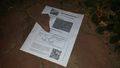
PDF poster for this location. (More information at User:Crox/Poster.)
Expedition
Bravissimo594 (talk)
This was about a 20-minute drive from home. The lack of significant traffic along the way on a Sunday evening made the trip smooth. Parking, on the other hand, is a big challenge in this neighborhood. I found a spot about a block away and walked up to the the hash point. After a GPS hash dance, I settled in on the spot, marked it with chalk, headed over to a nearby street light for a photo, snapped a few others, and then headed on my way. Quick and easy ... but without any other geohashers to be found. Boppy5 had to get up at 4:00am the next day, so I traveled alone on this one.
Tracklog
Photos
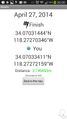
Success! Geohash Droid details. @34.0704,-118.2727
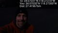
Under nearby street light. @34.0703,-118.2730
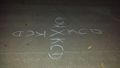
Street chalk at the spot. @34.0704,-118.2730
Marked with information. @34.0704,-118.2730
The street. @34.0703,-118.2730


