Difference between revisions of "2014-04-27 51 -114"
imported>Guzzby (→Plans) |
m (More specific location) |
||
| (13 intermediate revisions by 5 users not shown) | |||
| Line 15: | Line 15: | ||
}} | }} | ||
| − | + | ||
__NOTOC__ | __NOTOC__ | ||
== Location == | == Location == | ||
| − | + | ||
In front of 112 Solace Ridge Pl Calgary, Alberta Canada | In front of 112 Solace Ridge Pl Calgary, Alberta Canada | ||
== Participants == | == Participants == | ||
| − | + | ||
| − | |||
* [[User:Guzzby|Guzzby]] | * [[User:Guzzby|Guzzby]] | ||
== Plans == | == Plans == | ||
| − | + | ||
| − | + | Today's geohash is just 5km away from Friday's. Should be an easy one to get to. I'll drive out there at 1:00pm and pick up around 5 geocaches in the area. Then I'll head over to the geohash around 4:30 and take a few pictures. It is in an isolated cul-de-sac. I don't expect to meet anybody out there or stay to long. | |
== Expedition == | == Expedition == | ||
| − | |||
| − | + | Left the house at 1:00 pm and drove over to Cougar Ridge. The first geocache I was going to get was "Lesson 06: Steganography - CPS101". Its located in the woods behind Cougar Ridge. I have been here twice before looking for it and have yet to find it. This time the Cache Owner has given me a clue and after searching for 15 minutes I finally find it. | |
| − | + | ||
| + | Next I continued walking east in the woods and easily found "Paskapoo Slopes - Calgary Parks 100" geocache. I dropped off a travel bug, which is trying to get to Churchill, Manitoba. I continued northeast on the trail and easily found "Willy's Treasure Cache". I walked over to Old Banff Coach Road and tried to find the "Keturah" geocache. I must have been searching the shrubbery for 20 minutes, but never found it. I headed back to my car and then drove over to the "X marks the spot: Artist View Park - CCARS11" geocache and easily found it. Next I drove to the "Halloween Hideaway - CCARS11" geocache and easily found that one too! | ||
| + | |||
| + | It was almost 4:00 pm, so I drove over to the geohash site. When I got out of the car there were hounds at the house where the geohash was and they started howling. There was no one else around, so I quickly took a couple of pictures and then left. | ||
== Photos == | == Photos == | ||
| − | + | ||
| − | |||
| − | |||
<gallery perrow="5"> | <gallery perrow="5"> | ||
| + | Image:2014-04-27_51_-114_guzzby1.jpg | View to the Southwest | ||
| + | Image:2014-04-27_51_-114_guzzby2.jpg | View to the North | ||
</gallery> | </gallery> | ||
== Achievements == | == Achievements == | ||
{{#vardefine:ribbonwidth|800px}} | {{#vardefine:ribbonwidth|800px}} | ||
| − | + | ||
| + | {{Land geohash | latitude = 51 | longitude = -114 | date = 2014-04-27 | name = [[User:Guzzby|Guzzby]] }} | ||
<!-- =============== USEFUL CATEGORIES FOLLOW ================ | <!-- =============== USEFUL CATEGORIES FOLLOW ================ | ||
Delete the next line ONLY if you have chosen the appropriate categories below. If you are unsure, don't worry. People will read your report and help you with the classification.--> | Delete the next line ONLY if you have chosen the appropriate categories below. If you are unsure, don't worry. People will read your report and help you with the classification.--> | ||
| − | |||
| − | |||
| − | |||
| − | |||
| − | |||
| − | |||
| − | |||
| − | |||
[[Category:Expeditions]] | [[Category:Expeditions]] | ||
| − | + | [[Category:Expeditions with photos]] | |
| − | [[Category:Expeditions with photos]] | ||
| − | |||
| − | |||
| − | |||
| − | |||
| − | |||
[[Category:Coordinates reached]] | [[Category:Coordinates reached]] | ||
| − | + | {{location|CA|AB|RV}} | |
| − | |||
| − | |||
| − | |||
| − | |||
| − | |||
| − | |||
| − | |||
| − | |||
| − | |||
| − | |||
| − | |||
| − | |||
| − | |||
| − | |||
| − | |||
| − | |||
| − | |||
Latest revision as of 00:07, 10 August 2020
| Sun 27 Apr 2014 in 51,-114: 51.0703144, -114.2727035 geohashing.info google osm bing/os kml crox |
Location
In front of 112 Solace Ridge Pl Calgary, Alberta Canada
Participants
Plans
Today's geohash is just 5km away from Friday's. Should be an easy one to get to. I'll drive out there at 1:00pm and pick up around 5 geocaches in the area. Then I'll head over to the geohash around 4:30 and take a few pictures. It is in an isolated cul-de-sac. I don't expect to meet anybody out there or stay to long.
Expedition
Left the house at 1:00 pm and drove over to Cougar Ridge. The first geocache I was going to get was "Lesson 06: Steganography - CPS101". Its located in the woods behind Cougar Ridge. I have been here twice before looking for it and have yet to find it. This time the Cache Owner has given me a clue and after searching for 15 minutes I finally find it.
Next I continued walking east in the woods and easily found "Paskapoo Slopes - Calgary Parks 100" geocache. I dropped off a travel bug, which is trying to get to Churchill, Manitoba. I continued northeast on the trail and easily found "Willy's Treasure Cache". I walked over to Old Banff Coach Road and tried to find the "Keturah" geocache. I must have been searching the shrubbery for 20 minutes, but never found it. I headed back to my car and then drove over to the "X marks the spot: Artist View Park - CCARS11" geocache and easily found it. Next I drove to the "Halloween Hideaway - CCARS11" geocache and easily found that one too!
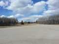
It was almost 4:00 pm, so I drove over to the geohash site. When I got out of the car there were hounds at the house where the geohash was and they started howling. There was no one else around, so I quickly took a couple of pictures and then left.
Photos

View to the Southwest
View to the North


Achievements
Guzzby earned the Land geohash achievement
|