Difference between revisions of "2014-04-30 49 -115"
imported>Guzzby (→Achievements) |
m (More specific location) |
||
| (5 intermediate revisions by 3 users not shown) | |||
| Line 19: | Line 19: | ||
== Location == | == Location == | ||
<!-- where you've surveyed the hash to be --> | <!-- where you've surveyed the hash to be --> | ||
| − | On crown land 30 meters | + | On crown land 30 meters North of Farstad Way. 20 Km Northeast of Kimberley, British Columbia Canada |
== Participants == | == Participants == | ||
| Line 45: | Line 45: | ||
Image:2014-04-30_49_-115_guzzby5.jpg | View of the hashpoint | Image:2014-04-30_49_-115_guzzby5.jpg | View of the hashpoint | ||
Image:2014-04-30_49_-115_guzzby6.jpg | View from the road | Image:2014-04-30_49_-115_guzzby6.jpg | View from the road | ||
| − | Image:2014-04-30_49_-115_guzzby7.jpg | Now that's a large | + | Image:2014-04-30_49_-115_guzzby7.jpg | Now that's a large geocache! |
Image:2014-04-30_49_-115_guzzby8.jpg | Big Horn sheep grazing at the gas station in Radium | Image:2014-04-30_49_-115_guzzby8.jpg | Big Horn sheep grazing at the gas station in Radium | ||
</gallery> | </gallery> | ||
| Line 54: | Line 54: | ||
{{Land geohash | latitude = 49 | longitude = -115 | date = 2014-04-30 | name = [[User:Guzzby|Guzzby]] }} | {{Land geohash | latitude = 49 | longitude = -115 | date = 2014-04-30 | name = [[User:Guzzby|Guzzby]] }} | ||
| + | {{Hash collision | latitude = 49 | longitude = -115 | date = 2014-04-30 | name = [[User:Guzzby|Guzzby]] | id = GC4CN5K | link = http://www.geocaching.com/geocache/GC4CN5K_b13-dont-for-get-your-h20 | distance = 620 meters | image = 2014-04-25_51_-115_guzzby7.jpg }} | ||
| − | |||
| − | |||
| − | |||
| − | |||
| − | |||
| − | |||
| − | |||
| − | |||
| − | |||
| − | |||
| − | |||
| − | |||
[[Category:Expeditions]] | [[Category:Expeditions]] | ||
| − | |||
[[Category:Expeditions with photos]] | [[Category:Expeditions with photos]] | ||
| − | |||
| − | |||
| − | |||
| − | |||
| − | |||
[[Category:Coordinates reached]] | [[Category:Coordinates reached]] | ||
| − | + | {{location|CA|BC|EK}} | |
| − | |||
| − | |||
| − | |||
| − | |||
| − | |||
| − | |||
| − | |||
| − | |||
| − | |||
| − | |||
| − | |||
| − | |||
| − | |||
| − | |||
| − | |||
| − | |||
| − | |||
Latest revision as of 00:07, 10 August 2020
| Wed 30 Apr 2014 in 49,-115: 49.9029067, -115.7529821 geohashing.info google osm bing/os kml crox |
Location
On crown land 30 meters North of Farstad Way. 20 Km Northeast of Kimberley, British Columbia Canada
Participants
Plans
When I saw this one pop up today, I thought it would be a good chance to get one of the distant geohashes that I need for my minesweeper achievement. This area has always been a favorite place to go for a drive too!. So I decided I would leave about 10:30 am and drive out there. I figured that I would stop in Invermere and have lunch. Then when I got to the hashpoint I was going to pick up two geocaches before coming home.
Expedition
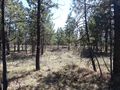
I left the house at 10:30 am. I got to Invermere about 1:00 pm, stopped for lunch and then continued on to Skookumchuk, where the hash point is. I got there about 2:00 pm, the woods at the hash point were fairly thin and it was an easy walk to ground zero. I took a couple of pictures and then walked over to the location of the "b13: dont for get your h20" geocache. From the log files I knew it was around 20 meters from ground zero and near a fence. I searched for about 20 minutes but couldn't find it. The cache owner works at the nearby plant and he saw me looking around and he came over and gave me a hint. Everything clicked, I couldn't believe I missed something so obviously out of place. The cache was very unique and is definitely one of my favorites. The cache owner also placed a second geocache ("b13: the game show") in the area about 200 yards away. It was an easy find, but it was also very unique and it was also one of the largest geocaches I have ever seen. Kudos to the cache owner know as "The Dude"
Photos
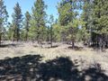
View to the north
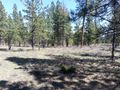
View to the east
View to the south
View to the west
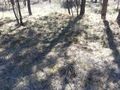
View of the hashpoint
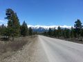
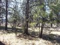
View from the road
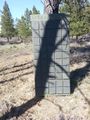
Now that's a large geocache!
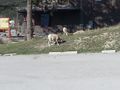
Big Horn sheep grazing at the gas station in Radium


Achievements
Guzzby earned the Land geohash achievement
|
Guzzby earned the Hash collision achievement
|