Difference between revisions of "2014-05-02 49 8"
imported>DODO (→Photos) |
|||
| (2 intermediate revisions by 2 users not shown) | |||
| Line 17: | Line 17: | ||
<!-- edit as necessary --> | <!-- edit as necessary --> | ||
__NOTOC__ | __NOTOC__ | ||
| + | [[2014-04-30_49_8|previous]] [[2014-05-21 49 8|next]] | ||
| + | |||
| + | |||
== Location == | == Location == | ||
<!-- where you've surveyed the hash to be --> | <!-- where you've surveyed the hash to be --> | ||
| Line 31: | Line 34: | ||
== Expedition == | == Expedition == | ||
<!-- how it all turned out. your narrative goes here. --> | <!-- how it all turned out. your narrative goes here. --> | ||
| − | After [[2014-04-30_49_8]] we had a party in the rowing club and so I left my bull there. I took the big car to get it from there and made just a little detour on my way back to the autobahn exit Kronau. I left the car there and used the bull for the last 2 KM. It violated my fuel policy a little, but I'm afraid the policy is a bit to harsh. Just after I parked the car I found a police control, but they didn't care for my bike, so no achievement. On my way I crossed a cement plant and found a lake before I turned into the | + | After [[2014-04-30_49_8]] we had a party in the rowing club and so I left my bull there. I took the big car to get it from there and made just a little detour on my way back to the autobahn exit Kronau. I left the car there and used the bull for the last 2 KM. It violated my fuel policy a little, but I'm afraid the policy is a bit to harsh. Just after I parked the car I found a police control, but they didn't care for my bike, so no achievement. On my way I crossed a cement plant and found a lake before I turned into the forest. I parked the bull where I found some lilies of the valley. From there it was just a 60 m walk. |
| − | The forest was very light and so the walk was easy and fast. Some hashdancing later I found several X on the ground. Ninja-hasher? I finished one of them to a complete hash-mark and left again. All in all a 30 KM detour with car and | + | The forest was very light and so the walk was easy and fast. Some hashdancing later I found several X on the ground. Ninja-hasher? I finished one of them to a complete hash-mark and left again. All in all a 30 KM detour with car and a 5 KM ride on my bull. |
== Tracklog == | == Tracklog == | ||
| Line 56: | Line 59: | ||
== Achievements == | == Achievements == | ||
{{#vardefine:ribbonwidth|800px}} | {{#vardefine:ribbonwidth|800px}} | ||
| − | + | {{land geohash | |
| + | | latitude = 49 | ||
| + | | longitude = 8 | ||
| + | | date = 2014-05-02 | ||
| + | | name = DODO | ||
| + | }} | ||
| − | + | {{Regional geohashing | |
| − | + | | name = [[User:DODO|DODO]] | |
| − | [[ | + | | region = Landkreis Karlsruhe |
| − | + | | count = 2 | |
| − | + | }} | |
| − | |||
| − | |||
| − | |||
| − | |||
| − | |||
| − | |||
[[Category:Expeditions]] | [[Category:Expeditions]] | ||
| − | |||
[[Category:Expeditions with photos]] | [[Category:Expeditions with photos]] | ||
| − | |||
| − | |||
| − | |||
| − | |||
| − | |||
[[Category:Coordinates reached]] | [[Category:Coordinates reached]] | ||
| − | + | {{location|DE|BW|KA}} | |
| − | |||
| − | |||
| − | |||
| − | |||
| − | |||
| − | |||
| − | |||
| − | |||
| − | |||
| − | |||
| − | |||
| − | |||
| − | |||
| − | |||
| − | |||
| − | |||
| − | |||
Latest revision as of 14:36, 1 May 2020
| Fri 2 May 2014 in 49,8: 49.2396901, 8.6084926 geohashing.info google osm bing/os kml crox |
Location
In a forest next to a lake near Kronau.
Participants
Plans
Expedition
After 2014-04-30_49_8 we had a party in the rowing club and so I left my bull there. I took the big car to get it from there and made just a little detour on my way back to the autobahn exit Kronau. I left the car there and used the bull for the last 2 KM. It violated my fuel policy a little, but I'm afraid the policy is a bit to harsh. Just after I parked the car I found a police control, but they didn't care for my bike, so no achievement. On my way I crossed a cement plant and found a lake before I turned into the forest. I parked the bull where I found some lilies of the valley. From there it was just a 60 m walk.
The forest was very light and so the walk was easy and fast. Some hashdancing later I found several X on the ground. Ninja-hasher? I finished one of them to a complete hash-mark and left again. All in all a 30 KM detour with car and a 5 KM ride on my bull.
Tracklog
Photos
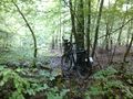
bull parking
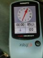
proof
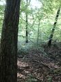
view from the hash
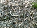
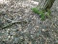
ninja hasher?
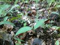
mark completed
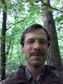
happy hasher
lilies of the valley
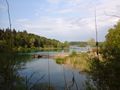
near lake
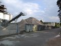
near cement plant
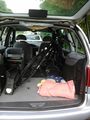
bull in big car


Achievements
DODO earned the Land geohash achievement
|
DODO earned the Regional geohashing achievement
|