Difference between revisions of "2014-05-03 47 5"
imported>JwB m (→Participants) |
m |
||
| (7 intermediate revisions by 2 users not shown) | |||
| Line 1: | Line 1: | ||
| − | + | [[Image:{{{image|2014-05-03 47 5 k.png}}}|thumb|left]] | |
| − | |||
| − | |||
| − | [[Image:{{{image| | ||
| − | |||
| − | |||
| − | |||
| − | |||
| − | |||
| − | |||
{{meetup graticule | {{meetup graticule | ||
| lat=47 | | lat=47 | ||
| Line 18: | Line 9: | ||
__NOTOC__ | __NOTOC__ | ||
== Location == | == Location == | ||
| − | + | The ruins of a WW1 fortress overlooking the Marne river near the intersection with the A31 highway | |
== Participants == | == Participants == | ||
| Line 24: | Line 15: | ||
== Plans == | == Plans == | ||
| − | + | Return back home from our vacation. Leave the highway to get breakfast croissants and bread neart an easily reachable hash. Then drive over there, collect proof, eat breakfast, run around with the kids, pee, and continue driving home. | |
== Expedition == | == Expedition == | ||
| − | |||
| − | + | Leaving the highway, finding a baker, and getting to the hill with the fortress was all smooth. Walking up to the main building was smooth as well. 300 meters to go... | |
| − | + | ||
| + | First try the straight way, around the east side. Fences and signs prohibiting entrance, but I could walk around these and stay on the allowed area. Walked around an abandoned caravan and some firewood, up to ~110 meters, when a steep trench went down (8 meters, but slippery from the rain, and straight walls with lots of overgrowth that is creeping in every crack between the stones. | ||
| + | |||
| + | Walked back, and saw a path going around the fortress by the west side, perhaps that would allow passage to the other side of the trench. The path wound round the fortress, and bridges from logs that were half rotten away allowed passage over the deepest trenches. There was a small chapel, half overgrown, and there were shelters for the men and the ammunition. | ||
| + | Path continued, and got more densely overgrown. Went up to 29 meters, and again a trench, this time steeper and more trees and obstacles. Remembered that wife+kids were still in the car, and that we had some 600 kms to travel back home. No real walking shoes, or proper gear, and if I fell into the trench, the home journey would be even more delayed. | ||
| + | |||
| + | So called it quits there. But the hill is nice, and great for a hike. | ||
== Photos == | == Photos == | ||
| − | |||
| − | |||
| − | |||
<gallery perrow="5"> | <gallery perrow="5"> | ||
| + | Image:2014-05-03 47 5 h.jpg | main building | ||
| + | Image:2014-05-03 47 5 k.png | trench with overgrowth | ||
</gallery> | </gallery> | ||
== Achievements == | == Achievements == | ||
{{#vardefine:ribbonwidth|800px}} | {{#vardefine:ribbonwidth|800px}} | ||
| − | |||
| + | {{Cliffs of Despair | ||
| + | | latitude = 47 | ||
| + | | longitude = 5 | ||
| + | | date = 2014-05-03 | ||
| + | | name = JwB | ||
| + | | terrain = trenches, straight down and slippery | ||
| + | | image = 2014-05-03 47 5 k.png | ||
| + | }} | ||
| − | |||
| − | |||
| − | |||
| − | |||
| − | |||
| − | |||
| − | |||
| − | |||
| − | |||
| − | |||
| − | |||
| − | |||
[[Category:Expeditions]] | [[Category:Expeditions]] | ||
| − | |||
[[Category:Expeditions with photos]] | [[Category:Expeditions with photos]] | ||
| − | |||
| − | |||
| − | |||
| − | |||
| − | |||
| − | |||
| − | |||
| − | |||
| − | |||
[[Category:Coordinates not reached]] | [[Category:Coordinates not reached]] | ||
| − | |||
| − | |||
[[Category:Not reached - Mother Nature]] | [[Category:Not reached - Mother Nature]] | ||
| − | + | {{location|FR|52}} | |
| − | |||
| − | |||
| − | |||
| − | |||
| − | |||
| − | |||
| − | |||
| − | |||
| − | |||
| − | |||
Latest revision as of 21:58, 14 March 2022

| Sat 3 May 2014 in 47,5: 47.9335309, 5.3084585 geohashing.info google osm bing/os kml crox |
Location
The ruins of a WW1 fortress overlooking the Marne river near the intersection with the A31 highway
Participants
Plans
Return back home from our vacation. Leave the highway to get breakfast croissants and bread neart an easily reachable hash. Then drive over there, collect proof, eat breakfast, run around with the kids, pee, and continue driving home.
Expedition
Leaving the highway, finding a baker, and getting to the hill with the fortress was all smooth. Walking up to the main building was smooth as well. 300 meters to go...
First try the straight way, around the east side. Fences and signs prohibiting entrance, but I could walk around these and stay on the allowed area. Walked around an abandoned caravan and some firewood, up to ~110 meters, when a steep trench went down (8 meters, but slippery from the rain, and straight walls with lots of overgrowth that is creeping in every crack between the stones.
Walked back, and saw a path going around the fortress by the west side, perhaps that would allow passage to the other side of the trench. The path wound round the fortress, and bridges from logs that were half rotten away allowed passage over the deepest trenches. There was a small chapel, half overgrown, and there were shelters for the men and the ammunition. Path continued, and got more densely overgrown. Went up to 29 meters, and again a trench, this time steeper and more trees and obstacles. Remembered that wife+kids were still in the car, and that we had some 600 kms to travel back home. No real walking shoes, or proper gear, and if I fell into the trench, the home journey would be even more delayed.
So called it quits there. But the hill is nice, and great for a hike.
Photos
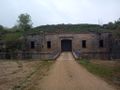
main building
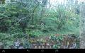
trench with overgrowth

Achievements
JwB earned the Cliffs of Despair consolation prize
|