Difference between revisions of "2014-05-16 47 -122"
imported>Thomcat ([live picture] North of point - trails match google and not plan. [http://www.openstreetmap.org/?lat=47.68626030&lon=-122.02113924&zoom=16&layers=B000FTF @47.6863,-122.0211]) |
imported>FippeBot m (Location) |
||
| (5 intermediate revisions by one other user not shown) | |||
| Line 20: | Line 20: | ||
Scouted first thing and it looked reasonable. A bit of legwork later on pulled up the name of the trail this hashpoint is near to - [http://your.kingcounty.gov/permits/info/UPD-RR/TrailMap-RRE.pdf Woodpecker Trail]. Based on that image, it looks like the hashpoint is close to a proposed trail marker... but then it also shows the trail continuing NW from there instead of angling back to the main road. Time to get a first-hand report! | Scouted first thing and it looked reasonable. A bit of legwork later on pulled up the name of the trail this hashpoint is near to - [http://your.kingcounty.gov/permits/info/UPD-RR/TrailMap-RRE.pdf Woodpecker Trail]. Based on that image, it looks like the hashpoint is close to a proposed trail marker... but then it also shows the trail continuing NW from there instead of angling back to the main road. Time to get a first-hand report! | ||
| + | Navigated to the area easily enough, though the streets and neighborhood are new enough that the car nav system thinks I am off-road. Found the crossing lane where the trail meets the road, check. No parking here, but I will only be snapping a few pictures. There is a trail on the other side leading the wrong direction and labeled "wetlands". Not on either the printed or google maps, so I bypass these and return to the car. | ||
| + | A little further down the road I find the East Branch trail which will lead to where I need to be. Another no parking sign at the trail head, but half a block away, no sign. No problem! | ||
| − | == | + | At this point I enter the trail system. Someone went to a lot of work (and expense) to create this trail system - I doubt much of it predated settlement in this area. That would be settlement in the last ten years. So, why was a lot of money spent here? |
| − | + | ||
| + | ... because it is a freaking swamp! The trail was wet in patches, winding near large puddles or small ponds (or possibly bogs). Present everywhere around me (and on me if I stopped) were mosquitoes. LOTS of mosquitoes. I passed horse droppings on the trail and saw tracks in mud, so I can see that walkers are not the only occupants. | ||
| + | |||
| + | Whilst being eaten alive I continued along the trail to the junction. I paused to snap a picture and upload using fairly low cell signal. This would get worse soon, and several pictures I took will have to be uploaded later on. In the space of my pause (breathing out the mosquitoes delicious carbon dioxide) I was swarmed. | ||
| + | |||
| + | This trail led eventually to the next junction, which was a handful of meters from the hashpoint. To the left was another trail, which I would return on - it was likely to lead to the road, which was not visible but not far away either. I snapped a picture of the hash poster attached to the fancy sign post while attempting to reduce my exhalation. I then trundled down the trail to reach the point. | ||
| + | |||
| + | *Here! -- [[User:Thomcat|Thomcat]] ([[User talk:Thomcat|talk]]) [http://www.openstreetmap.org/?lat=47.68455072&lon=-122.01949241&zoom=16&layers=B000FTF @47.6846,-122.0195] 14:54, 16 May 2014 (PDT) | ||
| + | |||
| + | The geohasher photo was also taken, but the upload stalled. Fine - time to bug out (literally). I headed down the left branch trail and quickly encountered... mud. Then a puddle the width of the trail. Then more mud. Not a major problem for horses, but it is for me. | ||
| + | |||
| + | Eventually I escaped to the road, and my picture finished upload. While walking down the road, I pondered this community. Redmond Ridge - ridge equals elevation, yet here is a wetland. Solution? Reduce it to manageable chunks and litter it with trails. "Lovely greenspace, perfect for walking dogs and riding horses." Hrmm... more like a mosquito breeding ground. I didn't see another human or large mammal on this trail, and wouldn't walk it myself without serious protection. | ||
| + | |||
| + | Anyone else want to move to West Nile? | ||
== Photos == | == Photos == | ||
| Line 32: | Line 47: | ||
Image:2014-05-16_47_-122_thomcat_1400276110265.jpg | North of point - trails match google and not plan. [http://www.openstreetmap.org/?lat=47.68626030&lon=-122.02113924&zoom=16&layers=B000FTF @47.6863,-122.0211] | Image:2014-05-16_47_-122_thomcat_1400276110265.jpg | North of point - trails match google and not plan. [http://www.openstreetmap.org/?lat=47.68626030&lon=-122.02113924&zoom=16&layers=B000FTF @47.6863,-122.0211] | ||
| + | Image:2014-05-16_47_-122_WetlandTrail.jpg | Wetland trail leading away | ||
| + | Image:2014-05-16_47_-122_UpdatedMap.jpg | Updated map | ||
| + | |||
| + | Image:2014-05-16_47_-122_thomcat_1400276585176.jpg | [http://www.openstreetmap.org/?lat=47.68441108&lon=-122.02572561&zoom=16&layers=B000FTF @47.6844,-122.0257] | ||
| + | |||
| + | Image:2014-05-16_47_-122_BreedingGround.jpg | Here breed mosquitoes | ||
| + | Image:2014-05-16_47_-122_Marker.jpg | Added XKCD to signpost | ||
| + | Image:2014-05-16_47_-122_Mosquito.jpg | Average size of mosquito | ||
| + | |||
| + | Image:2014-05-16_47_-122_thomcat_1400277323800.jpg | Upload finally completed [http://www.openstreetmap.org/?lat=47.68518338&lon=-122.01973956&zoom=16&layers=B000FTF @47.6852,-122.0197] | ||
</gallery> | </gallery> | ||
| + | |||
| + | |||
== Achievements == | == Achievements == | ||
| Line 39: | Line 66: | ||
| − | |||
| − | |||
| − | |||
[[Category:Expeditions]] | [[Category:Expeditions]] | ||
| − | |||
[[Category:Expeditions with photos]] | [[Category:Expeditions with photos]] | ||
| − | |||
| − | |||
| − | |||
| − | |||
| − | |||
[[Category:Coordinates reached]] | [[Category:Coordinates reached]] | ||
| − | + | {{location|US|WA|KN}} | |
| − | |||
| − | |||
| − | |||
| − | |||
| − | |||
| − | |||
| − | |||
| − | |||
| − | |||
| − | |||
| − | |||
| − | |||
| − | |||
| − | |||
| − | |||
| − | |||
| − | |||
Latest revision as of 06:32, 14 August 2019
| Fri 16 May 2014 in Seattle: 47.6845277, -122.0193904 geohashing.info google osm bing/os kml crox |
Location
Just off the Woodpecker Trail, in Redmond Ridge East.
Participants
Plans
Stop by after work, then take the toll bridge back to Seattle.
Expedition
Scouted first thing and it looked reasonable. A bit of legwork later on pulled up the name of the trail this hashpoint is near to - Woodpecker Trail. Based on that image, it looks like the hashpoint is close to a proposed trail marker... but then it also shows the trail continuing NW from there instead of angling back to the main road. Time to get a first-hand report!
Navigated to the area easily enough, though the streets and neighborhood are new enough that the car nav system thinks I am off-road. Found the crossing lane where the trail meets the road, check. No parking here, but I will only be snapping a few pictures. There is a trail on the other side leading the wrong direction and labeled "wetlands". Not on either the printed or google maps, so I bypass these and return to the car.
A little further down the road I find the East Branch trail which will lead to where I need to be. Another no parking sign at the trail head, but half a block away, no sign. No problem!
At this point I enter the trail system. Someone went to a lot of work (and expense) to create this trail system - I doubt much of it predated settlement in this area. That would be settlement in the last ten years. So, why was a lot of money spent here?
... because it is a freaking swamp! The trail was wet in patches, winding near large puddles or small ponds (or possibly bogs). Present everywhere around me (and on me if I stopped) were mosquitoes. LOTS of mosquitoes. I passed horse droppings on the trail and saw tracks in mud, so I can see that walkers are not the only occupants.
Whilst being eaten alive I continued along the trail to the junction. I paused to snap a picture and upload using fairly low cell signal. This would get worse soon, and several pictures I took will have to be uploaded later on. In the space of my pause (breathing out the mosquitoes delicious carbon dioxide) I was swarmed.
This trail led eventually to the next junction, which was a handful of meters from the hashpoint. To the left was another trail, which I would return on - it was likely to lead to the road, which was not visible but not far away either. I snapped a picture of the hash poster attached to the fancy sign post while attempting to reduce my exhalation. I then trundled down the trail to reach the point.
- Here! -- Thomcat (talk) @47.6846,-122.0195 14:54, 16 May 2014 (PDT)
The geohasher photo was also taken, but the upload stalled. Fine - time to bug out (literally). I headed down the left branch trail and quickly encountered... mud. Then a puddle the width of the trail. Then more mud. Not a major problem for horses, but it is for me.
Eventually I escaped to the road, and my picture finished upload. While walking down the road, I pondered this community. Redmond Ridge - ridge equals elevation, yet here is a wetland. Solution? Reduce it to manageable chunks and litter it with trails. "Lovely greenspace, perfect for walking dogs and riding horses." Hrmm... more like a mosquito breeding ground. I didn't see another human or large mammal on this trail, and wouldn't walk it myself without serious protection.
Anyone else want to move to West Nile?
Photos
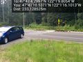
North of point - trails match google and not plan. @47.6863,-122.0211
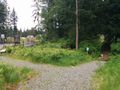
Wetland trail leading away
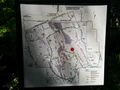
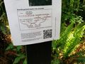
Updated map
Here breed mosquitoes
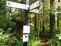
Added XKCD to signpost
Average size of mosquito

Upload finally completed @47.6852,-122.0197


